Blog Article
Nice Weather Map: U.P. Michigan Today, Oregon Coast Tomorrow
Wednesday's best air sits in Michigan's U.P. and a broad Nice band from Seattle to DC, while Thursday flips west to Oregon's coast and a 71-day CA streak rolls on.
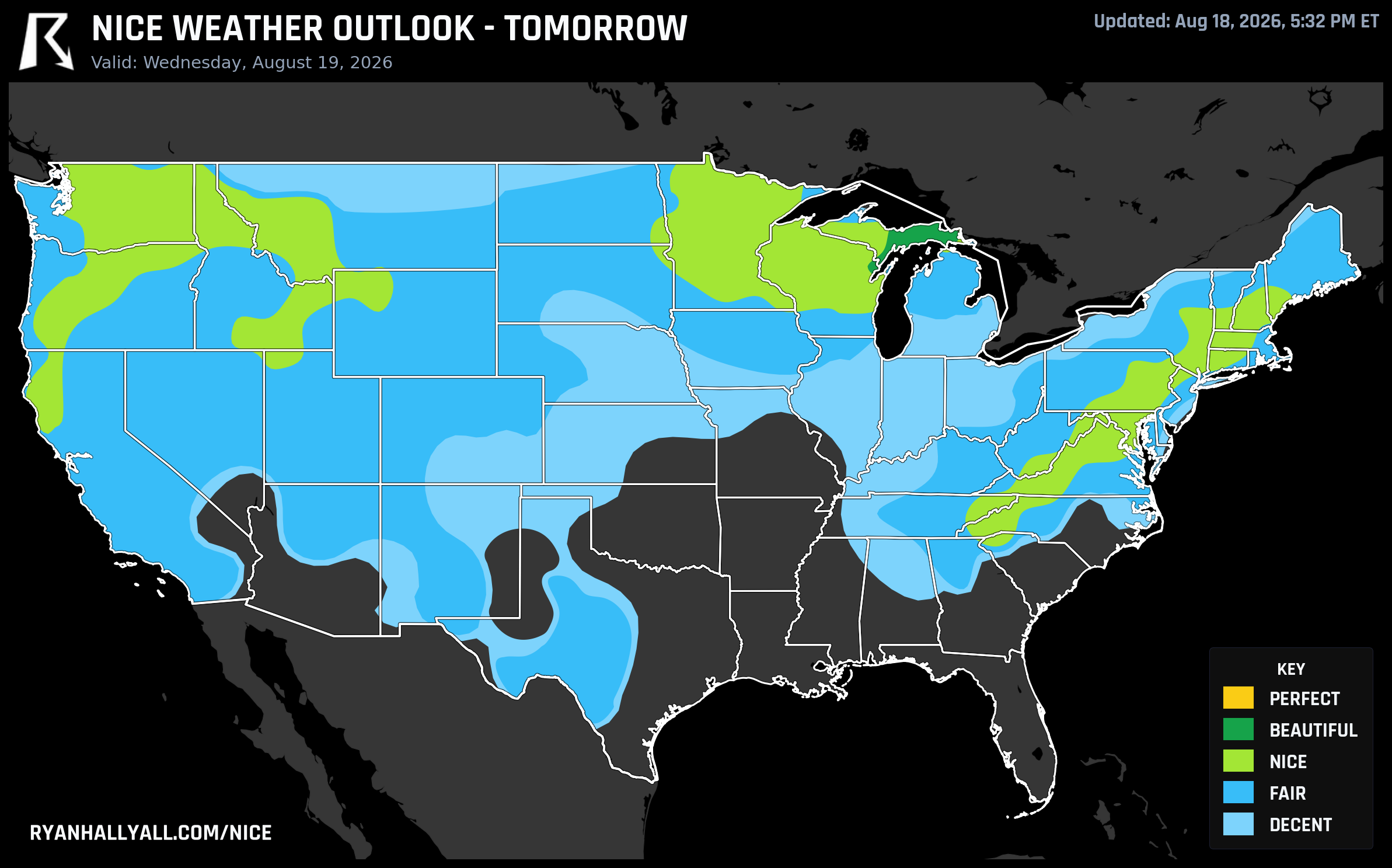
Michigan's U.P. Grabs Today's Best Air, the Oregon Coast Gets Tomorrow's, and Sacramento Just Keeps Rolling
Wednesday's map has two stories worth telling, and neither of them is about heat. The best air in the country today is tucked into the eastern Upper Peninsula, a broad comfortable band stretches from the Pacific Northwest to the Mid-Atlantic, and tomorrow the whole picture shifts west toward the Oregon coast. Tucked in the background is a quieter number: a run of California cities that haven't dipped below Nice since early June.
Today's top tier: eastern U.P. and northeast Wisconsin
If you're anywhere near Sault Ste. Marie, Marinette, Manistique, Newberry, or Menominee today, you've got the best weather in the country. A fresh, dry high pressure system settled in behind Tuesday's front and left highs near 73°F, dewpoints in the mid-50s, just 15% cloud cover, and winds light enough that boats and paddleboards will barely notice them. This zone scores 88.6 out of 100, which is Beautiful territory, and every single sub-score (dewpoint, precipitation, heat stress, temperature, sky, wind) already clears the bar for Perfect.
So why isn't it Perfect? Air quality. The zone's AQI runs around 43, and the Perfect tier requires 35 or below. It's a clean, safe number by any health standard, just not clean enough to clear that tighter gate. That's been the theme most of this week, comfortable air getting stopped short of the top by haze rather than heat, rain, or wind.
The broad Nice band: Seattle to DC
Away from that small Beautiful pocket, a wide Nice-tier stretch covers the northern Rockies, the Upper Midwest, and the Northeast, touching Seattle, Minneapolis, Worcester, Springfield, Allentown, New Haven, the Tri-Cities, Spokane, and Washington, DC. Highs run around 81°F with dewpoints near 51°F, genuinely comfortable air for patio lunches or a school pickup in short sleeves. Seattle and Minneapolis sit near the top of that group; Lewiston, Maine is the softest member, held back by 52% cloud cover and a gustier afternoon.
Again, it's AQI doing the capping. The zone average of 67, with some CAMS readings spiking past 130 in spots, keeps this band at Nice instead of Beautiful even though the sky and dewpoint numbers on their own would clear that gate.
One planning note for DC and the Mid-Atlantic: enjoy today, because the pattern doesn't hold. WPC's short-term discussion has a slight risk of excessive rainfall sliding east into the Mid-Atlantic coast by Thursday, right behind the cold front that's giving today's comfortable air its dry punch. If you've got outdoor plans in that corridor later this week, keep an eye on the sky.
Thursday flips the map to the Oregon coast
By Thursday, the best conditions relocate to a narrow strip of western Oregon and southwest Washington, specifically Florence, Seaside, Salem, and Olympia. Marine air keeps this corridor in the 70s right on the coast even as inland spots like Roseburg and Salem's warmer neighbors push into the low 90s. It's the day's only Beautiful zone, scoring 86.0, and it's basically maxed out on dewpoint, precipitation, wind, and sky. The one soft spot is inland heat trimming the temperature sub-score.
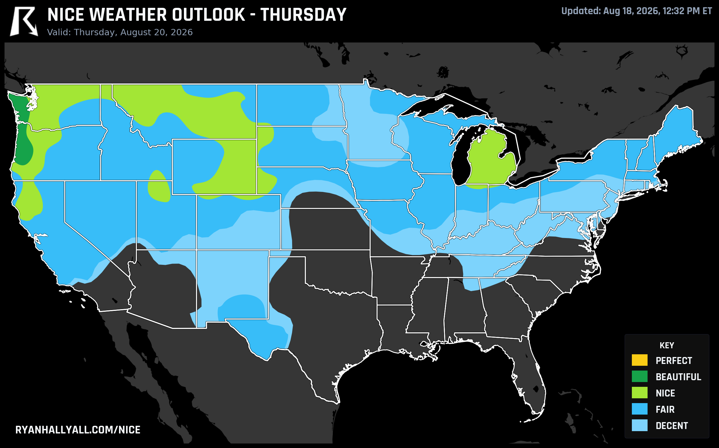
This is also where the week's quiet winner lives. Look at the Nice Weather outlook page weekly rankings and you'll find a cluster of small Douglas County, Oregon towns, Sutherlin, Oakland, Melrose, Drain, and Yoncalla, sitting at the very top with a full seven-day streak of Nice-or-better conditions and a Beautiful peak arriving Thursday. These aren't places that usually make headlines, but if you're road-tripping I-5 through southern Oregon this week, you've picked a genuinely good stretch to do it.
The other streak nobody's talking about
While today's map favors the Great Lakes and the Northeast, there's a separate, longer-running story sitting quietly in California's Central Valley and East Bay. Sacramento, Stockton, Oakland, Berkeley, Napa, Roseville, and more than a dozen nearby cities have now logged 71 straight days at Nice or better, a streak that traces back to early June. It's not a headline-grabbing Beautiful stretch, it's the marine-moderated Northern California summer just doing its steady, boring, reliable thing day after day. If you want dependable outdoor weather without checking the forecast every morning, that corridor has quietly earned it.
What to watch beyond this week
The broader pattern context is worth keeping in your back pocket. CPC's extended outlook flags a potentially major, long-duration heat event building over the southern Plains and Desert Southwest by the August 26-28 window, with that ridge expected to expand westward afterward. None of that touches today's nice zones, but it's the reminder that this comfortable stretch in the Great Lakes and Northeast, and the coastal Oregon Beautiful pocket tomorrow, are enjoying a pattern that's living on borrowed time in the bigger picture. UV today is modest across the nicest zones (low to mid single digits to around 7), so sun protection isn't a major concern, but the AQI story is worth remembering if you have respiratory sensitivities, since even Beautiful-tier air today is running in the 40s rather than the 30s.
For now, though: pack a light jacket for a cool U.P. morning, grab a coastal Oregon hike tomorrow if you can, and if you live anywhere near Sacramento, just keep doing what you're doing.