Blog Article
Maine Hits Perfect Friday as Great Lakes Enjoy Beautiful Air
Today's nicest air sits over South Bend and Kalamazoo, but Friday brings a true Perfect score to northern Maine while the weekend spreads Beautiful conditions west.
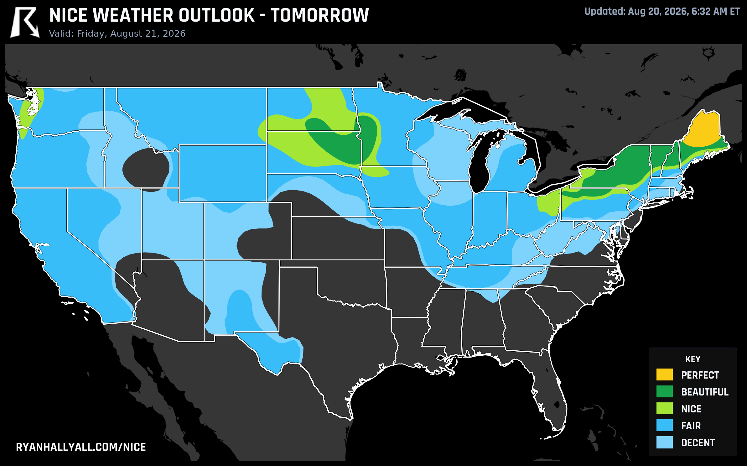
Maine Actually Gets to Perfect on Friday While the Great Lakes Settle for Beautiful
Most days on this map, the top tier stays just out of reach. Something always trims a point or two off the ceiling, whether it's a stray cloud, a slightly sticky dewpoint, or hazy air from a fire hundreds of miles away. Today isn't one of those days everywhere, but it is close in a couple of spots, and by Friday one corner of the country actually clears every bar the scale has to offer.
Today: South Bend and Kalamazoo get the good stuff
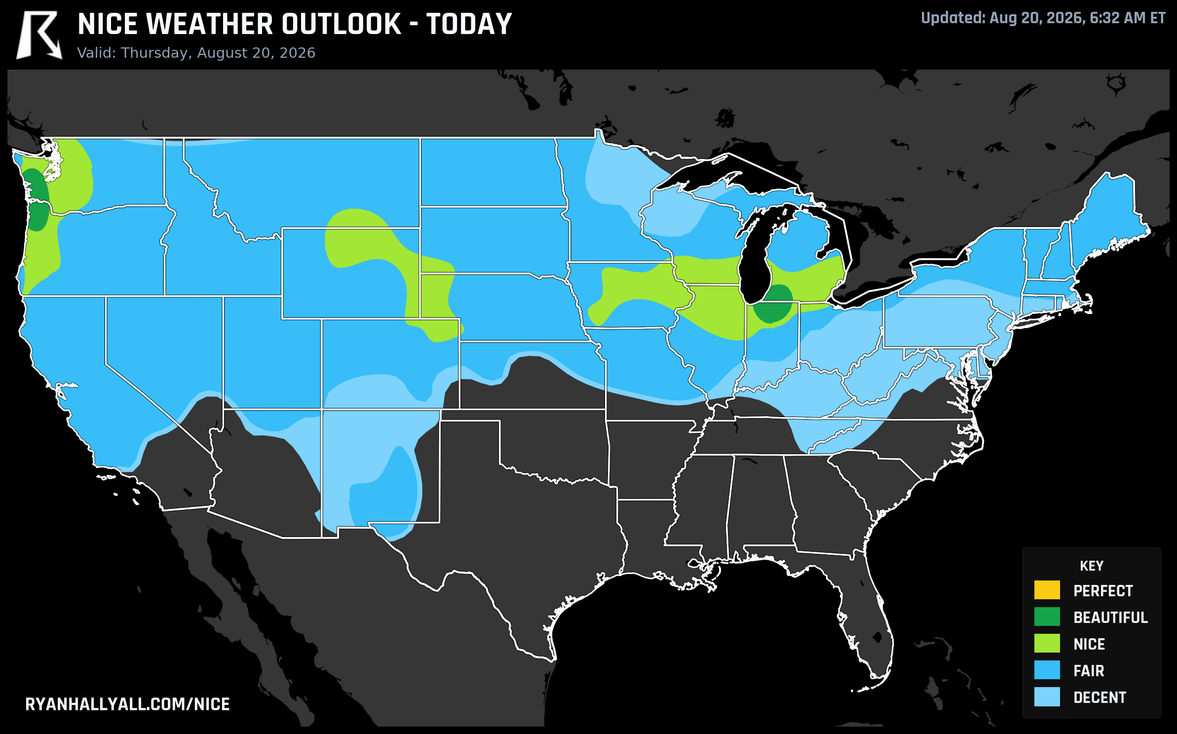
If you're anywhere near South Bend, Elkhart, Mishawaka, or Kalamazoo this afternoon, you've got the best conditions in the country, and it's a proper patio day. Highs land near 79 to 81°F, dewpoints sit in the upper 50s to low 60s, winds stay under 10 mph, and skies run just 7 percent cloud cover. The sub-scores back it up: wind at 99.8 and sky at 98.9 are about as clean as this metric ever gets. What keeps it at Beautiful instead of Perfect is almost nothing, a few degrees of dewpoint and a few degrees of temperature away from the strictest gate.
Hillsboro, Oregon rides along in the same tier at 79.3, but it's a good reminder that comfort isn't only about temperature and humidity. A touch of background wildfire smoke pushes its AQI to 73, still fine to be outside, but enough to trim the score in an otherwise flawless setup. Chicago, Seattle, and Milwaukee all land a notch below at Nice, held back mostly by a bit more cloud and breeze.
Friday: a handful of Maine towns clear every gate
Here's the rarer story. A dry Canadian high slides down into the Northeast on Friday, and across Aroostook and Piedmont counties in far northern Maine, it produces genuinely maxed-out numbers. Houlton, Millinocket, East Millinocket, Medway, and Patten all post perfect 100.0 scores. Highs run about 73 to 77°F, dewpoints sit near 51°F, winds barely move at 5 to 6 mph, cloud cover stays under 20 percent, and AQI holds in the low 30s. Precipitation and wind sub-scores hit a literal 100. There's nowhere left for this air to improve.
Meanwhile, the broader Great Lakes and Northeast, think Rochester, Syracuse, Fargo, Schenectady, Utica, Burlington, and Bangor, all land at a strong 92 and Beautiful, just one tier down. The gap isn't really about the weather itself. Temperature, dewpoint, wind, and sky sub-scores are all excellent across this zone. It's air quality doing the trimming: AQI running 41 to 50 in these cities, just above the strict 35-or-under threshold that Perfect demands. Shave off fifteen points of AQI and most of this belt would join Maine at the top.
One trade-off worth knowing about if you're headed into the woods up there: the same dry pattern that's producing this air also raises fire weather concern across central and eastern Oregon and Washington on Friday, with gusty winds ahead of an approaching system. Not a concern in Maine, but worth watching if your outdoor plans are farther west.
The weekend: Beautiful spreads out, but the calendar itself caps it
By Saturday, the best conditions shift to a wide stretch of the northern High Plains and interior West: Rochester, Minnesota, Grand Forks and West Fargo in North Dakota, Mankato, and a run of interior California and Oregon towns including Redding, Chico, Medford, and Davis. Scores reach 92 in several of these spots, and the sub-scores are close to flawless: precipitation and dewpoint both score in the high 90s, skies stay under 15 percent cloud cover, and PoP sits at just 1 percent.
Here's the catch. Saturday is Day 3 on the outlook, and forecasts three days out are capped at Beautiful regardless of how good the numbers look, simply because confidence that far ahead isn't strong enough to promise a true Perfect. The zone actually sits only about 5 points below that ceiling, so if this pattern holds, it wouldn't take much to get there on a shorter-range update.
If you're headed to Cleveland for the Bills-Browns preseason game Saturday, keep an eye on the sky. The Storm Prediction Center has a marginal severe risk stretched from the upper Ohio Valley into the lower Great Lakes that afternoon, mostly a concern for gusty storm clusters rather than anything widespread.
The bigger picture
All of this comfortable air owes itself to the same setup driving the week's rougher weather elsewhere. A cold front out of Canada is pushing into the Northeast even as a stubborn heat dome holds firm across the southern tier, and the collision between the two is fueling the slight risk of heavy rain and severe storms sliding from the Ohio Valley into the Mid-Atlantic coast today and Friday. The same amplifying ridge over the Plains that's kept Nebraska and Kansas under a severe storm watch this week is also the reason the central Plains and Midwest stay capped at Fair or worse through the weekend, even with decent temperatures, because cloud cover, convection, and in some spots real air quality problems keep tripping the safety gates.
So the short version: dry, clean, gentle air up north and out west, muggy instability and storm risk lodged in the middle and along the Mid-Atlantic coast, and a stretch of Southern heat that isn't going anywhere according to the extended outlook. UV runs in the moderate-to-high 6 to 7 range across most of the nice zones today and Friday, so sunscreen still matters even on the mildest afternoons.
For the full current picture and the days ahead, check the Nice Weather outlook page, and if you're near northern Maine on Friday, that's about as good as this scale gets.