Blog Article
Sacramento's 74-Day Streak and a Near-Perfect Dakota Weekend
Northern California's Central Valley hits a 74-day Nice streak while the Dakotas edge toward Perfect Saturday. See where the nicest air in the country is heading this weekend.
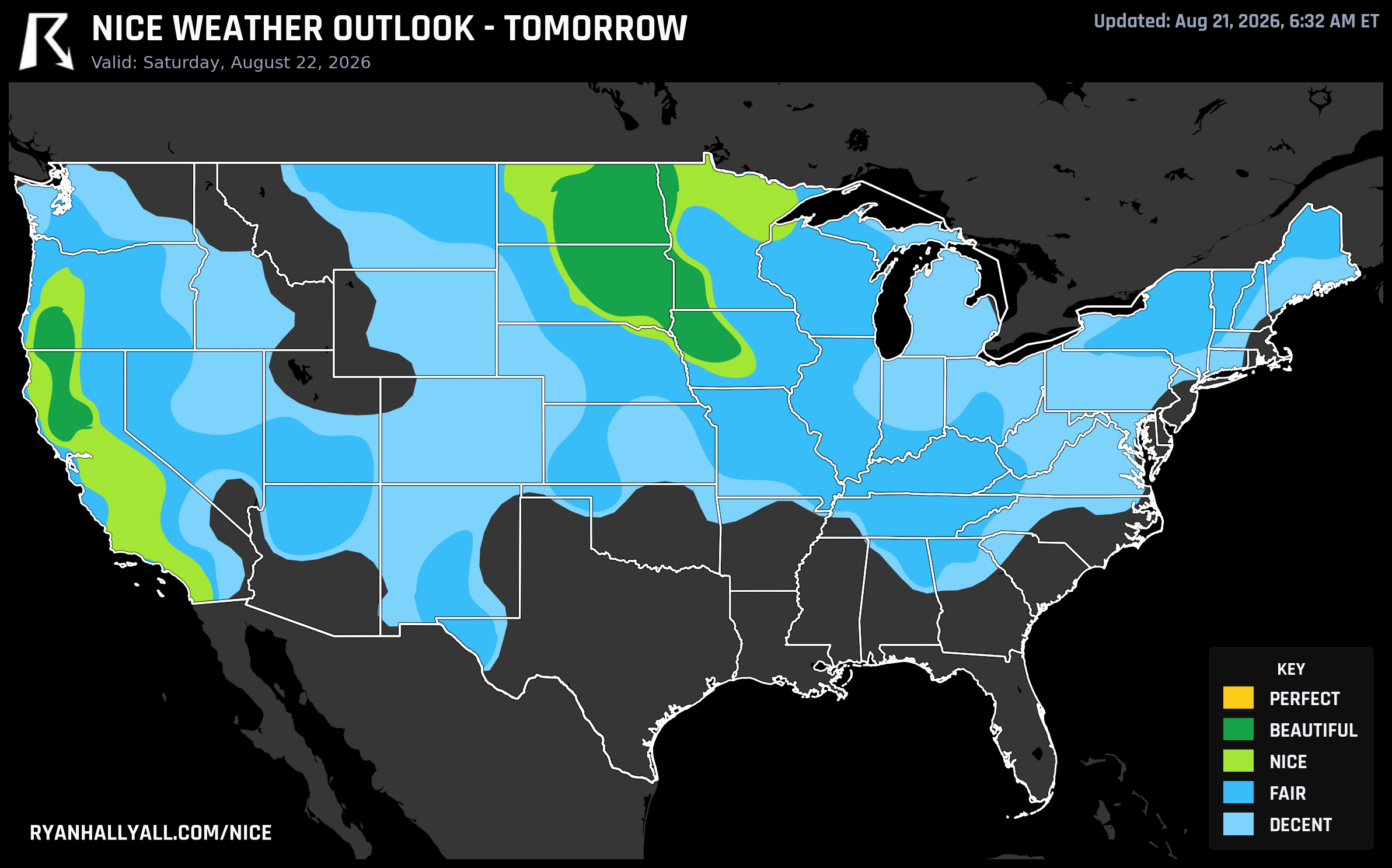
Sacramento's 74-Day Nice Streak Meets a Near-Perfect Saturday in the Dakotas
After the tornadoes, the 82 mph gusts in western Kentucky, and the flash flooding that soaked Ohio and the Mid-Atlantic on Thursday, it's worth pointing the map somewhere calmer. Two threads stand out today: a quietly remarkable streak running through California's Central Valley and East Bay, and a genuine near-miss at the top of the scale building over the Dakotas for Saturday.
Tonight: Pittsburgh Gets the Better End of the Deal
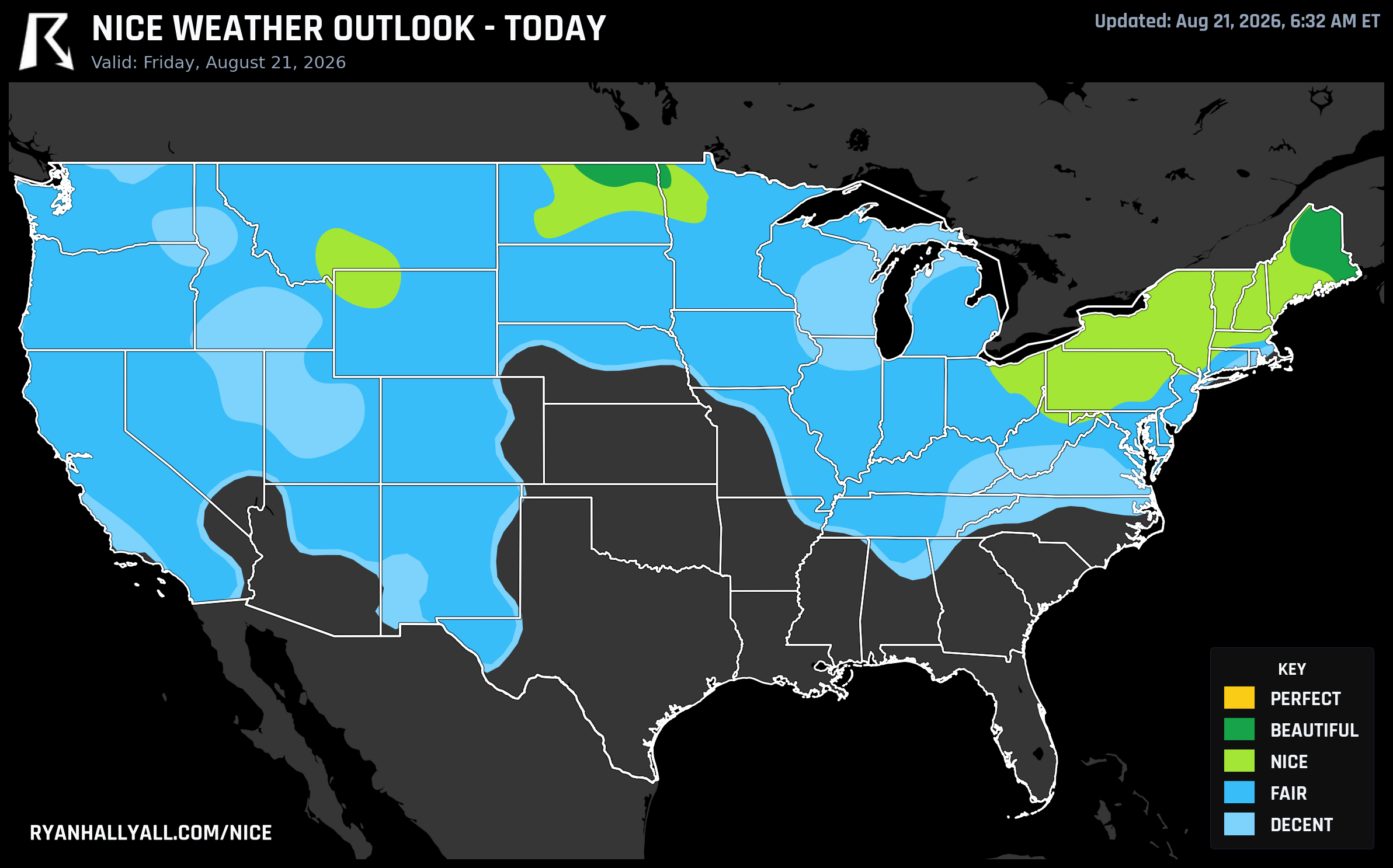
If you're headed to Acrisure Stadium for the Jets-Steelers preseason game tonight, you picked a good night for it. Pittsburgh sits inside today's Nice-tier zone stretching across the northern Great Lakes and Ohio Valley, with highs settling into the mid-70s after morning fog clears and wind staying light, around 6 to 9 mph. Cleveland, Buffalo, Rochester, Syracuse, Manchester, Erie, and Albany are all riding the same air mass, scoring in the 79 to 81 range today.
The actual best air in the country sits a bit north of all that, across northern Maine and North Dakota, where Presque Isle, Caribou, Houlton, Millinocket, and Devils Lake are running dew points near 50°F, less than 5 percent cloud cover, and almost zero rain chance. The only thing keeping that zone from cracking Perfect is bookkeeping: the effective air quality index runs around 46, and Perfect requires 35 or better. Every actual weather sub-score there, temperature, wind, sky, humidity, heat stress, already clears the bar. It's clean air, just not quite clean enough by the numbers.
The Streak Nobody's Talking About
Here's the quieter story. Sacramento, Oakland, Stockton, Berkeley, Napa, Alameda, Concord, Fairfield, Roseville, Citrus Heights, Manteca, Pleasanton, Rancho Cordova, and a run of other Central Valley and East Bay cities are currently sitting on a 74-day streak of Nice-or-better weather. That's essentially the entire span this streak tracking covers, back to June 9. Most of these cities touched actual Perfect once, on June 21, and haven't needed to since. Nice has just been the floor, day after day, through a summer that's been rough on a lot of the rest of the country.
It's not a fluke of scoring. The Delta breeze keeps evenings mild even when afternoon highs push into the 90s, humidity stays low, and the marine influence from the Bay does a lot of quiet work. Farther north, Willits and Brooktrails in Mendocino County are the week's single best-performing towns anywhere in the country, averaging 83.4 across all seven forecast days with a Perfect-tier 92.0 showing up on Sunday.
One honest caveat: comfortable numbers on this scale don't mean zero fire risk. Saturday's fire weather outlook flags a Critical designation for parts of northeast California, northwest Nevada, and south-central and southeast Oregon, where relative humidity drops into the teens and winds gust 20 to 25 mph. If you're in that corridor, including around Medford, check local air quality and burn restrictions even on an otherwise gorgeous day.
Saturday: The Dakotas Get Close
Saturday's best zone sits over the central High Plains, roughly the Dakotas and adjacent areas, where a Canadian ridge is pumping in dry, mild air. Sioux Falls, Bismarck, Sioux City, and Grand Forks all post a clean 92.0, landing in Beautiful territory. Chico, CA and Medford, OR sit right there too. The zone-wide score comes in at 89.7, just 2.3 points off Perfect, and once again it's the air quality gate doing the limiting, not the weather itself. Effective AQI runs around 44 against a 35 threshold, while temperature, wind, sky, dew point, and heat stress sub-scores all clear the Perfect bar on their own.
Sunday: The Torch Passes to the Upper Midwest
By Sunday, a post-frontal, drying air mass sets up the best conditions over the Upper Midwest and interior Pacific Northwest, with Madison, Rockford, Eugene, Bend, Medford, Appleton, and Waukesha all scoring 92.0. Chicago and Salem check in lower, around 72, a reminder that even inside a favorable zone, local wind and humidity can pull individual cities down. Sunday also happens to be the last day Beautiful is even possible under how this outlook is structured. Day 1 and Day 2 can reach Perfect, Day 3 tops out at Beautiful no matter the score, and Days 4 through 7 are capped at Nice regardless of how good the raw numbers look. It's a confidence discount for longer lead times, not a knock on the actual weather.
That rule shows up clearly later this week. Philadelphia, Seattle, Washington DC, and Portland all keep posting Nice-tier scores in the high 70s and low 80s through midweek, numbers that would be Beautiful on paper if not for the calendar cutoff.
What to Watch Elsewhere
None of this is happening in a vacuum. The Weather Prediction Center still has a Slight risk of excessive rainfall over Virginia and the Carolinas today, with a Slight severe risk for damaging wind gusts across the same corridor plus the Midwest. And looking into next week, the Climate Prediction Center is flagging a potentially major, long-duration heat event building across the Desert Southwest, Southern Rockies, and Central and Southern Plains starting around August 28. UV index across most of today's nice zones runs in the 6.5 to 7 range too, comfortable air temperature aside, so sunscreen still earns its keep on an all-day outdoor plan.
For the full picture, including tomorrow's map and the rest of the week, check the Nice Weather outlook page. The short version: the calm is real in a few specific places right now, it's just not evenly distributed, and the ceiling keeps getting nudged by AQI more than by the sky itself.