Blog Article
Sunday Brings a Rare Perfect-Tier Nice Weather Day to Iowa/Wisconsin
Dubuque, Clinton, and the Driftless region hit genuine Perfect-tier weather Sunday, the best day of the week, while tonight's NFL games sit under a Slight Risk.
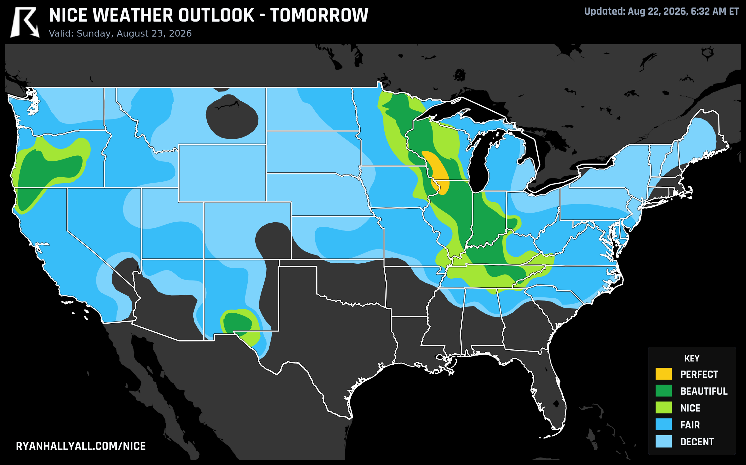
Sunday's the Ceiling: A True Perfect Pocket Lands in the Upper Mississippi Valley
Most days on the nice weather map top out at Beautiful and call it a win. Sunday actually gets there. A small corridor of the Upper Mississippi Valley is set to hit genuine Perfect-tier air, the highest category on the scale and the best score anywhere in this seven-day outlook. That's the headline. But there's also a more immediate story tonight, because two NFL preseason crowds are walking straight into a Slight Risk zone for severe storms while the rest of the country splits between a handful of Beautiful pockets and a lot of hazy, hot, or stormy in-between.
Sunday's the One to Circle
Dubuque and Clinton, Iowa, Freeport, Illinois, and Sparta and Reedsburg, Wisconsin, are set to score 95 or better on Sunday, which is about as clean as this outlook gets. Dubuque tops out near 76.6°F with a 51.4°F dewpoint and just 10.3 mph wind. Clinton runs a touch warmer at 77.6°F with a 53.8°F dewpoint, and Freeport, Sparta, and Reedsburg sit cooler still, in the low-to-mid 70s with dewpoints in the upper 40s to low 50s. Cloud cover in this pocket averages just 23%, rain chances sit at 0%, and both UV (around 6.5) and AQI (30 to 35) come in comfortably clean, which matters because those two gates are exactly what kept Saturday's warmest spots from reaching this tier. This is porch-coffee, farmers-market, full-day-outside weather with basically nothing working against it.
Step just outside that corridor and Sunday is still very good. Chicago, Indianapolis, Louisville, Cincinnati, Madison, and Knoxville all land in Beautiful territory, with highs generally in the high 70s to low 80s and dewpoints in the low 50s. It's a wide, comfortable band across the Midwest and Ohio Valley, just not quite as flawless as that Driftless-region core.
Tonight's Football Sits Under a Slight Risk
Back to today. If you're headed to Cleveland for Bills-Browns or Cincinnati for Bears-Bengals, know that both cities fall inside today's SPC Slight Risk zone for severe thunderstorms, part of a broader Ohio Valley band affecting roughly 13.6 million people with scattered damaging gusts the primary concern. The nice weather discussion flags this same region as capped well below its potential today specifically because of that storm threat, even though the base temperature and humidity look fine on paper.
Meanwhile, the day's actual Beautiful tier is running elsewhere. Grand Forks, North Dakota is sitting pretty at 74.9°F with a 53.6°F dewpoint, Burlington, Vermont checks in at 77.3°F with a 56.2°F dewpoint, and out west, Redding, Medford, and Stockton are all posting strong scores in the dry air behind recent fronts. El Paso and Las Cruces round out the list, running warmer and drier. Worth noting: this western group sits near the northern edge of a critical fire weather area today covering northeast California, the Great Basin, and Pacific Northwest interior, so dry sunny days don't come without a wildfire caveat this week, and El Paso's UV index near 7.2 is exactly what's keeping it out of the very top tier despite an otherwise excellent forecast.
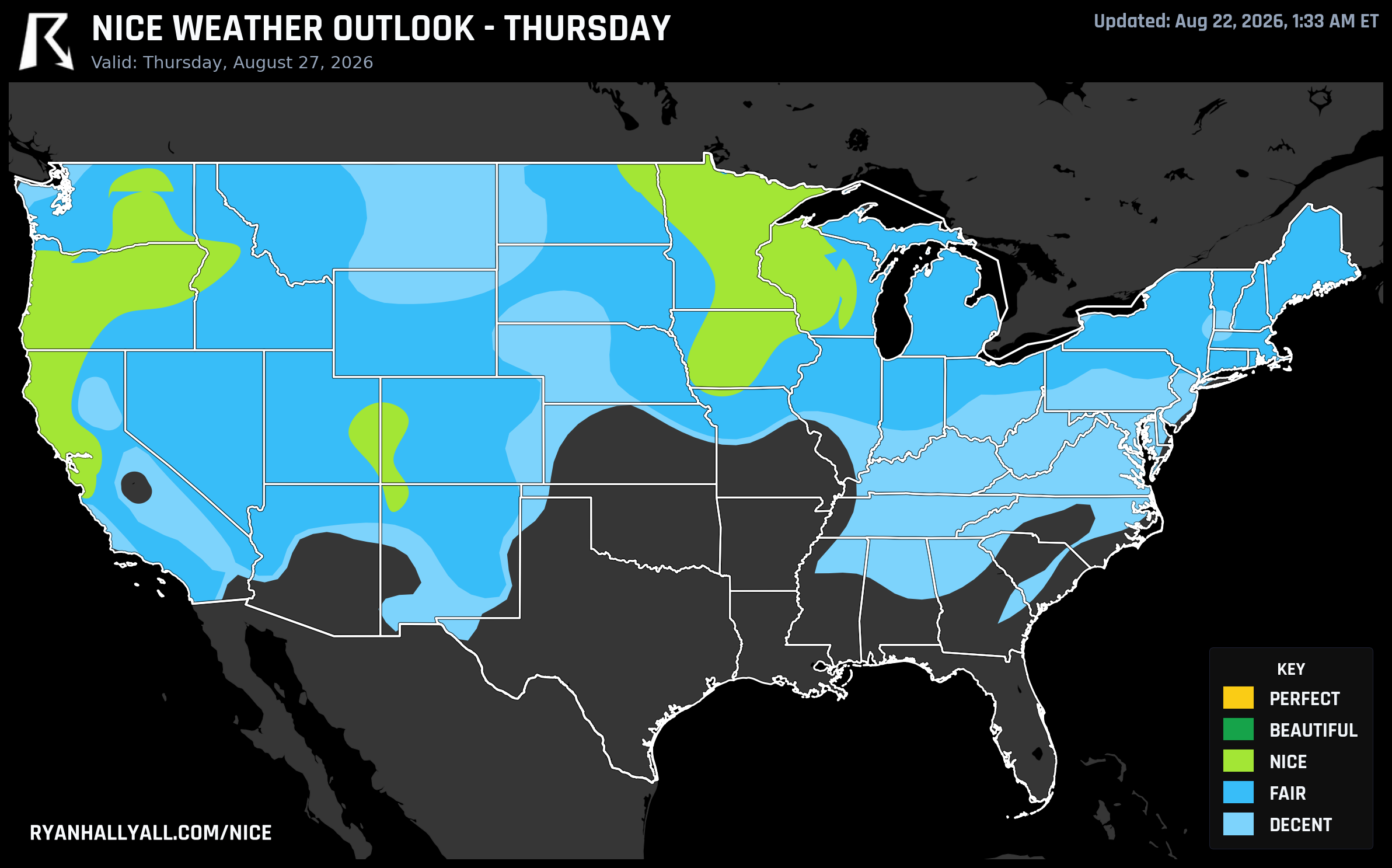
The Ceiling Comes Down, Then Moves West
Monday keeps the momentum in the Great Lakes and Ohio Valley, with Chicago, Columbus, Washington DC, Milwaukee, and Green Bay all reaching Beautiful behind cool high pressure and clean air. After that, the forecast-day rules cap every day from Tuesday through the following Friday at Nice, and the best air migrates: Tuesday favors the Northeast and San Jose, Wednesday shifts toward the Southwest and northern Plains, and by the weekend the top spots relocate to San Jose, Portland, Minneapolis, and the northern Rockies. That Thursday window lines up nicely with the Minnesota State Fair opening in Falcon Heights, where Minneapolis is projected to sit at a solid Nice score of 82. Meanwhile, CPC's extended outlook is blunt about the flip side of this pattern: a long-duration heat event is building across the Desert Southwest, southern Plains, and Lower Mississippi Valley into early September, so the comfortable stretch this week is largely a northern and western story.
A Quiet California Streak Keeps Rolling
One more thread worth a mention without belaboring it. Sacramento, Stockton, Shasta, Walnut Grove, and a long list of Central Valley and East Bay cities are now sitting on a 75-day streak without a single day below Nice, running back to early June. It's not flashy day to day, but stacked up it's one of the more remarkable runs on the map right now. The only asterisk is the same one that applies to most of interior California this week: keep an eye on air quality and fire weather advisories even on days that score well, since smoke can sneak in and change the picture fast.
For the fuller picture, including the day by day maps, the Nice Weather outlook page is the place to watch this Perfect pocket move through and see where the best air lands next.