Blog Article
Beautiful Weather Run: Ohio Valley to DC Through Tuesday
A dry, high pressure stretch from the Ohio Valley into the Mid-Atlantic peaks Tuesday in DC. See why it's Beautiful, not Perfect, and what's next.
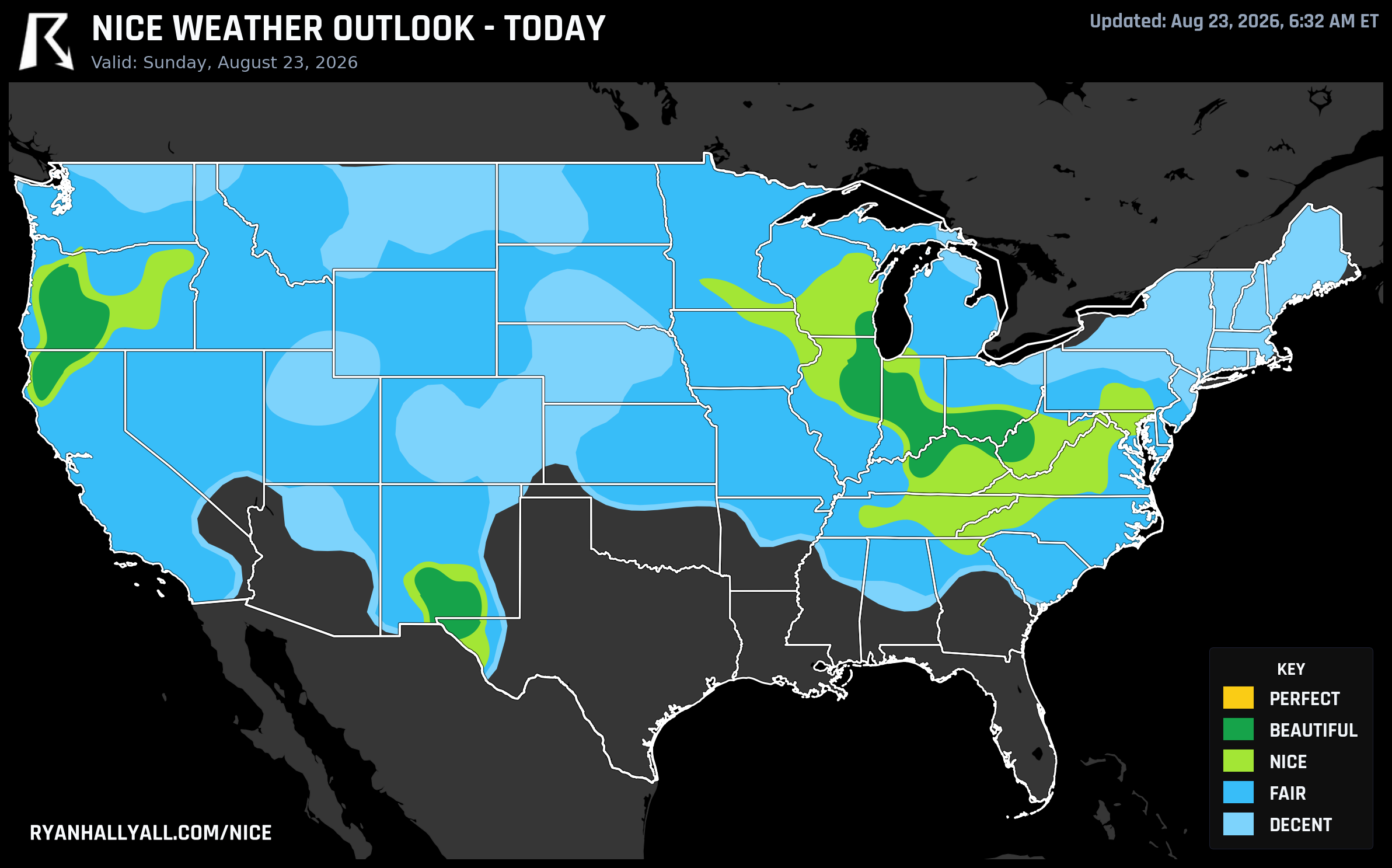
The Ohio Valley to DC Run: Three Days of Beautiful Weather That Keep Almost Touching Perfect
Sunday afternoon in Louisville looks about as good as August gets. Dry air, a 92.0 score, the best single-city reading anywhere in today's outlook. A couple hundred miles up I-65, Indianapolis and Chicago aren't far behind. And if you're headed to the Grand Prix of Washington, D.C. today, or catching the Rays and Orioles at Camden Yards this afternoon, you're standing in the same air mass, just on the leading edge of it.
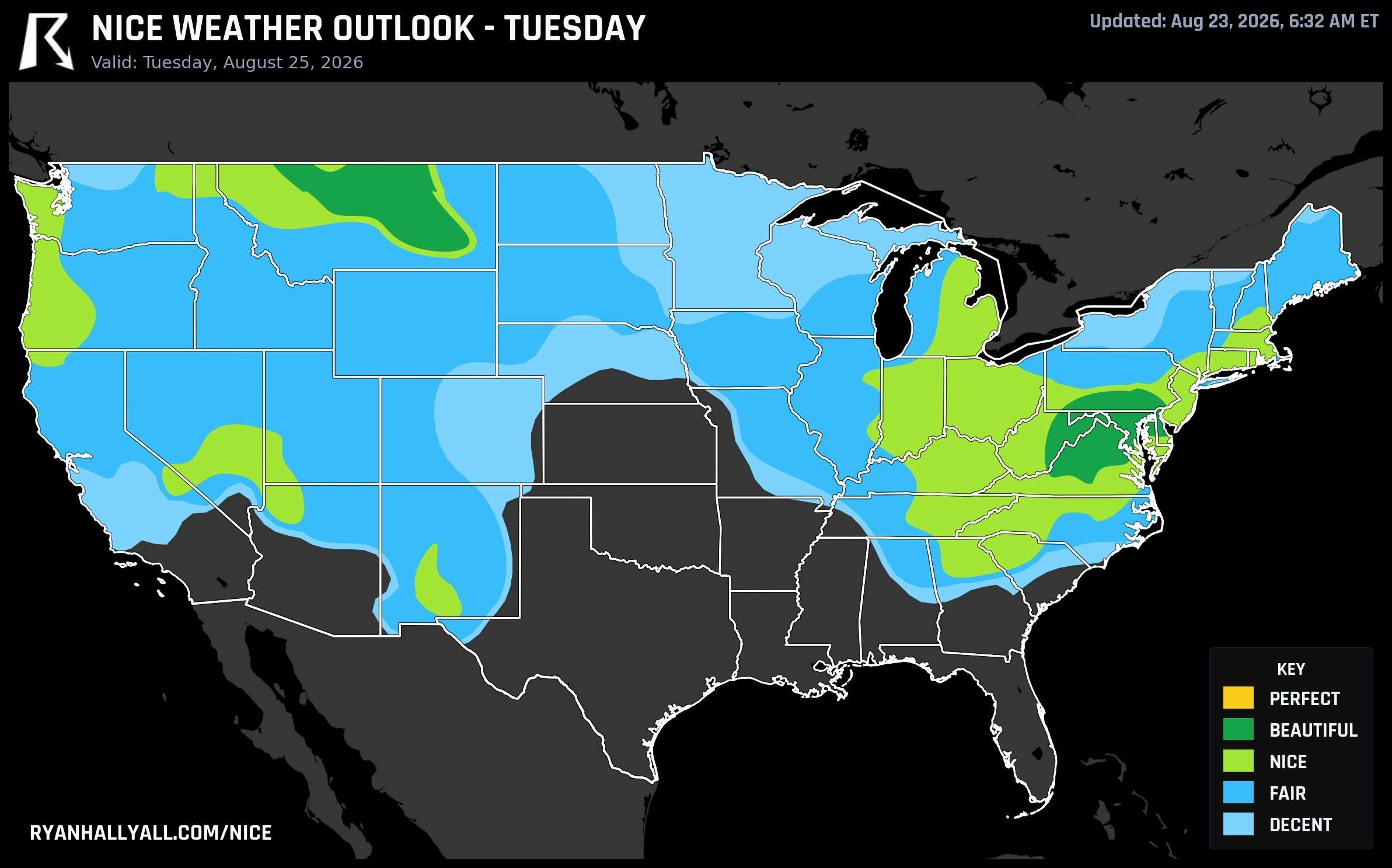
Here's the fun part. This corridor doesn't fade after today. It rolls east and actually gets better. DC scores a Nice-tier 82.0 today, climbs into Beautiful territory Monday, then on Tuesday hits 92.0, the single best score anywhere in the entire seven day outlook. If you've got flexibility on when to walk the National Mall, sit outside near Capitol Hill, or catch the Phillies in Philadelphia (who are similarly riding this same dry stretch), Tuesday is the day to build around.
Why It Won't Quite Hit Perfect
The forecast discussion for today's Beautiful zone is almost funny in how close it gets. Precipitation scores 99.1 out of 100. Sky cover scores 98.8. Dewpoints near 53°F push the humidity sub-score to 96.7. Every single comfort variable is knocking on Perfect's door. What actually holds it back is UV running around 7.1, just over the threshold, and an AQI near 44, nine points over the Perfect gate of 35. Some of that is ordinary late-summer haze. Some of it is smoke drifting in from western wildfire activity, the same fires turning parts of the American West's forests into shrubland this season. It's not enough to make the day unpleasant, but it's enough to cap the ceiling.
Tuesday's Mid-Atlantic zone tells a similar story. Heat stress scores 98.3, dewpoint scores 97.3, but Day 3 sits outside the forecast window that allows a Perfect label at all, so Beautiful is the honest ceiling regardless of how clean the numbers look. Either way, dress for it: 82 to 84°F, dewpoints near 50, breeze around 10 mph. That's about as comfortable as an outdoor lunch gets in late August.
The Quiet Standout Nobody's Talking About
While the Mid-Atlantic story is the one with events attached, the actual highest raw scores in this week's dataset belong to the Umpqua Valley in southern Oregon. Roseburg, Sutherlin, Oakland, and a string of small towns nearby are posting scores in the high 90s today, essentially brushing up against the top of the scale. It won't make headlines because there's no ballpark or motorsport event tied to it, but if you happen to be anywhere along I-5 near Roseburg this week, you're in the best air on the map, full stop.
Worth a mention too: Sacramento, Stockton, Oakland, and a wide swath of California's Central Valley and Bay Area are riding a 76-day streak at Nice-or-better, dating back to late June. That's not a fluke of the data, it's just how dry air keeps scoring well there even through warm afternoons. Just know the tradeoff going in, that stretch includes some genuinely hot, sun-baked days where the dryness alone is doing the heavy lifting on the score.
What's Not Part of the Nice Story
The rest of the map has its own weather going on, and none of it touches the corridors above. Southern New Mexico and far west Texas are running near 100°F with a real heat risk, part of the same Southwest ridge WPC has flagged as a multi-day, potentially record-setting heat event. The Storm Prediction Center has a Slight Risk of severe storms today across the northern Rockies and eastern Great Basin, and a Critical fire weather area is up across the inland Pacific Northwest with dry thunderstorms possible near Spokane and the Idaho Panhandle. None of that reaches into the Ohio Valley or Mid-Atlantic corridor, but if your plans involve Salt Lake City, Billings, or the Tri-Cities region this week, keep an eye on those separate hazards.
Looking Past Tuesday
By Wednesday the pattern shifts. A building Southwest ridge starts pulling the nicest air northward, away from the central Plains and into the northern High Plains and eventually the Pacific Northwest. Day 4 and 5 both cap at Nice rather than Beautiful, with Farmington, NM and later Omaha and Portland taking over as the week's best individual scores. By Day 7, Seattle, Portland, and Spokane become the strongest zone in the country, a full reversal from where we started this week. It's a lower confidence read that far out, but the northwest drift is consistent across all four days in the discussion, so it's worth watching rather than planning firmly around yet.
For the day by day breakdown and the latest maps as this pattern evolves, the Nice Weather outlook page is the place to track it.