Blog Article
Beautiful Weather Spreads Coast to Coast This Labor Day Weekend
Central New York hits Beautiful today, then the same dry air widens into a Great Lakes-to-Bay Area Beautiful arc by Sunday and the best Nice zone of the week on Labor Day.
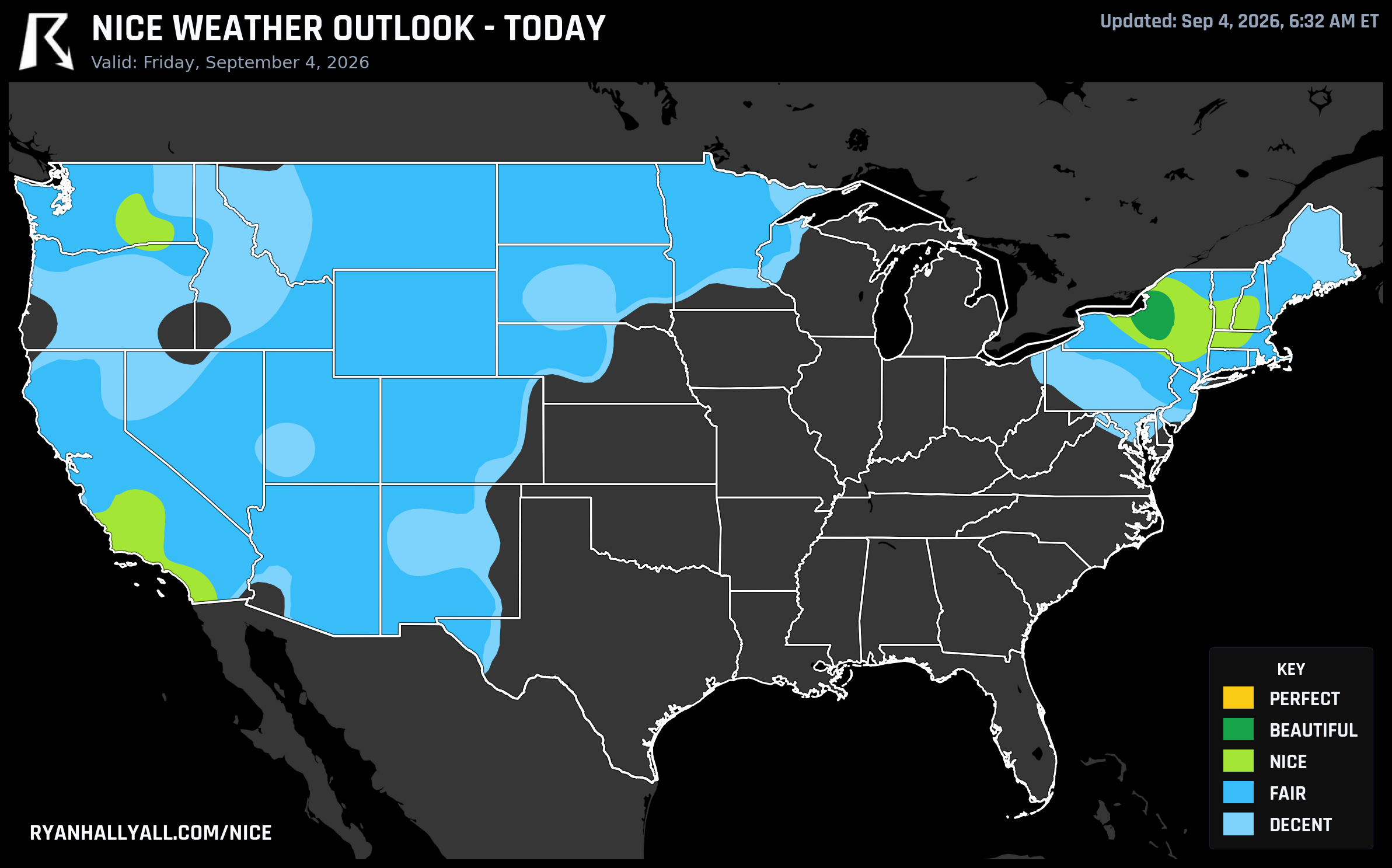
Central New York's Beautiful Friday Kicks Off a Coast-to-Coast Nice Labor Day Weekend
Today's map has one clear standout, and it's a small one geographically but a real one numerically. Central New York, the stretch running Syracuse to Utica to Watertown to Cortland to Oswego, is sitting at 92 out of 100 this afternoon, the only Beautiful score anywhere in the country today. Everywhere else worth mentioning is Nice or Fair. But the more interesting part of this story isn't today. It's what this same air mass does over the next 72 hours.
Today's Beautiful Pocket: Central New York
Syracuse, Utica, and their neighbors are riding highs near 72 degrees, dewpoints in the upper 50s, and winds a manageable 11 mph with gusts to 19. PoP is running just 5 percent, AQI is a clean 42, and the only real flaw in the outlook is some lingering morning fog and 30-plus percent cloud cover before things clear out. If you're at the Great New York State Fairgrounds area or just running errands in Oswego, this is about as good as early September gets. If you're closer to Lake George for tonight's Adirondack Independence Music Festival with moe. and more, you're not technically inside the top-scoring footprint, but you're breathing from the same dry, cool Canadian pool that's driving Syracuse's number, so expect a comfortable evening with a light jacket by the encore.
A broad Nice-to-Fair band stretches from there all the way to the Pacific Coast. Los Angeles (80.7), San Diego (81.6), Bakersfield (80.9), and Oxnard (81.4) are all Nice today, as is Tri-Cities, WA (82.0) and Rochester, NY (81.0). The catch in that western tier is mostly wind and warmth, not rain. Fresno is the softest link in that group at 71.3, held down by temperature more than anything else.
The Weekend Widens
Here's where it gets fun. Saturday, the Beautiful zone doesn't just hold, it recruits. Binghamton and Syracuse both post 92s, and Scranton (82) and Medford, OR (72) join the Beautiful tier as the same fresh air mass pushes across the interior Northeast and northern Great Lakes shoreline. Dewpoints in that zone average a crisp 56 degrees, winds are down to 9 mph, and PoP sits at 5 percent.
Then Sunday, the pattern goes from regional story to genuinely national one. A strengthening Canadian high scours humidity out of the Great Lakes, Ohio Valley, Northeast, and Mid-Atlantic at the same time a cooler coastal pattern is doing the identical job for California's Bay Area. San Jose and San Francisco both hit 92, Buffalo hits 92, Madison hits 92, Salinas and Rockford both hit 92, Detroit reaches 82, and Syracuse holds at 92 for a third straight day. That's a Beautiful arc running from the Pacific coast to the Atlantic coast on the same calendar day, driven by two separate but complementary high pressure setups. Highs in that zone average a comfortable 76 degrees with 15 percent cloud cover and just a 3 percent shower chance.
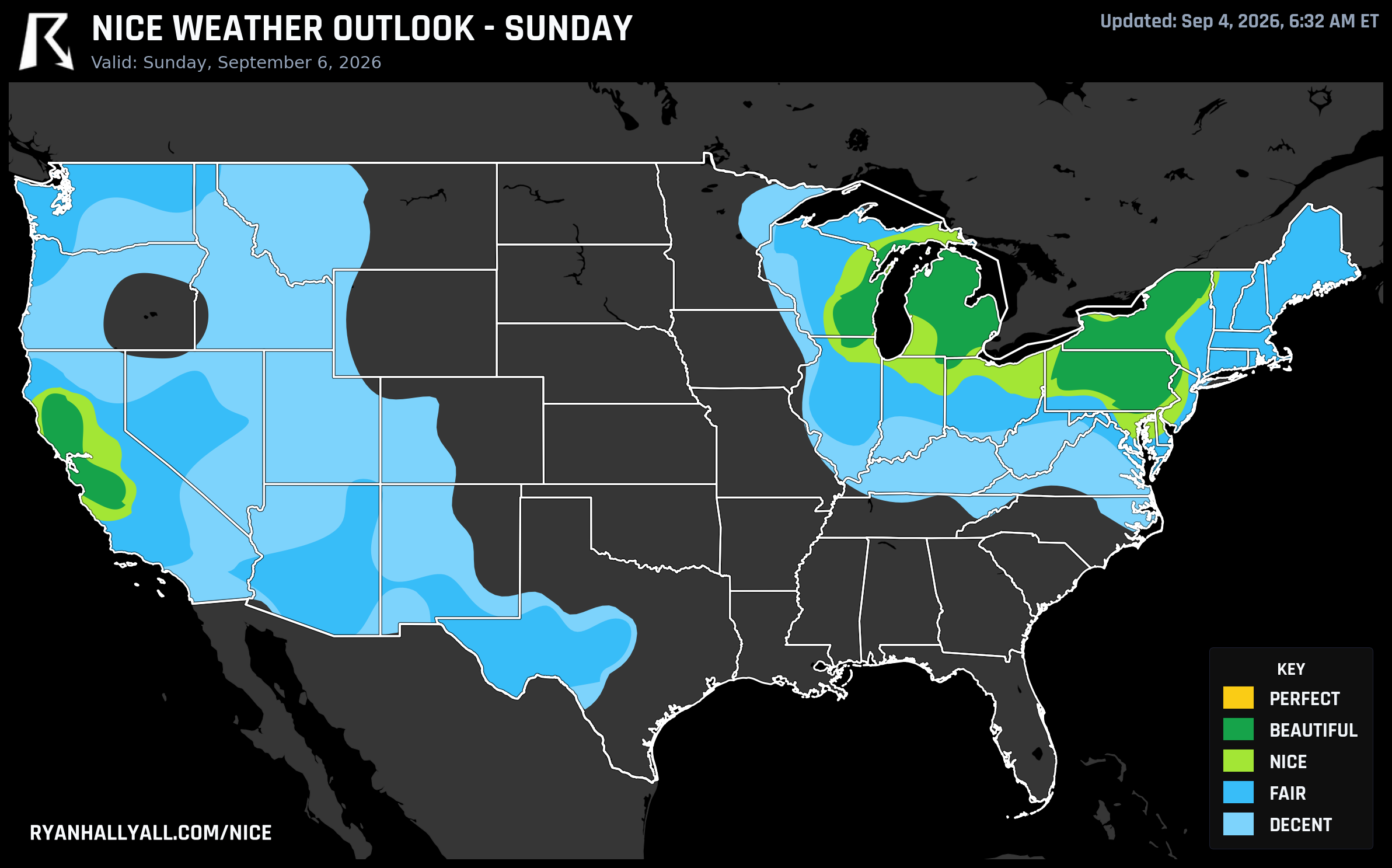
Labor Day: The Best Single Zone Score of the Whole Stretch
Monday is Labor Day, and it turns out to be the sneaky MVP of this outlook. The best zone that day, a broad swath running from the Ohio Valley into the Northeast and down into the mid-South, scores 79.8, which the forecast discussion flags as the single highest zone score of the entire four-day extended period. Philadelphia (81.6), Washington, DC (82.0), Boston (82.0), Nashville (81.5), and San Francisco (81.9) all land in Nice territory, with highs generally in the upper 70s and PoP near 3 percent. It's capped at Nice rather than Beautiful purely by the forecast-day rule that limits how high scores can go this far out, not because the underlying air is lacking. If you're grilling, hiking, or driving somewhere for the long weekend, Monday across that corridor is the safer bet of the whole outlook.
After that, the pattern gets messier fast. By Tuesday and Wednesday, the ridge axis slides west and the best dry air relocates to the Great Basin (Las Vegas, Salt Lake City, Pocatello), where desert heat becomes the new limiting factor even with essentially cloudless skies. By Thursday and Friday, model agreement drops and the only reliably nice pockets shrink to slivers of Montana and north-central Washington, including Yakima and Wenatchee.
The Catch
This stretch of good weather isn't happening in a vacuum. The same upper-level trough over southeastern Canada that's flushing out the humidity behind it is also the trigger for a real severe weather setup today across the southern Great Lakes and mid-to-upper Ohio Valley into the Mid-Atlantic, a Slight Risk corridor covering Columbus, Detroit, Washington, DC, and Virginia Beach with damaging wind gusts possible. That risk slides toward the central Appalachians and Carolinas on Saturday. So the nice air and the rough air are essentially riding the same weather system, just on opposite sides of the front. And well south of all this, the WPC extended discussion is blunt about a dangerous, long-duration heat wave settling over the central and southern Plains into the Mississippi Valley through the middle of next week, which is exactly why those regions stay stuck in Decent territory while the Northeast and Great Lakes get to enjoy the reward.
One more note if you're outdoors for extended stretches in the good zones: UV index runs 6 to 7 across most of this footprint, moderate-to-high for early September sun, so don't let the comfortable temperatures fool you into skipping sunscreen at the festival or the tailgate.
For the full breakdown of scores, city rankings, and the daily maps behind all of this, the Nice Weather outlook page has the complete picture day by day.