Blog Article
Nice Weather Tracker: Ridge Moves NW to Rockies to Great Lakes
A building high pressure system delivers Beautiful-tier weather to the Pacific Northwest today, the northern Rockies Wednesday, and Wisconsin by Thursday. Here's the full breakdown.
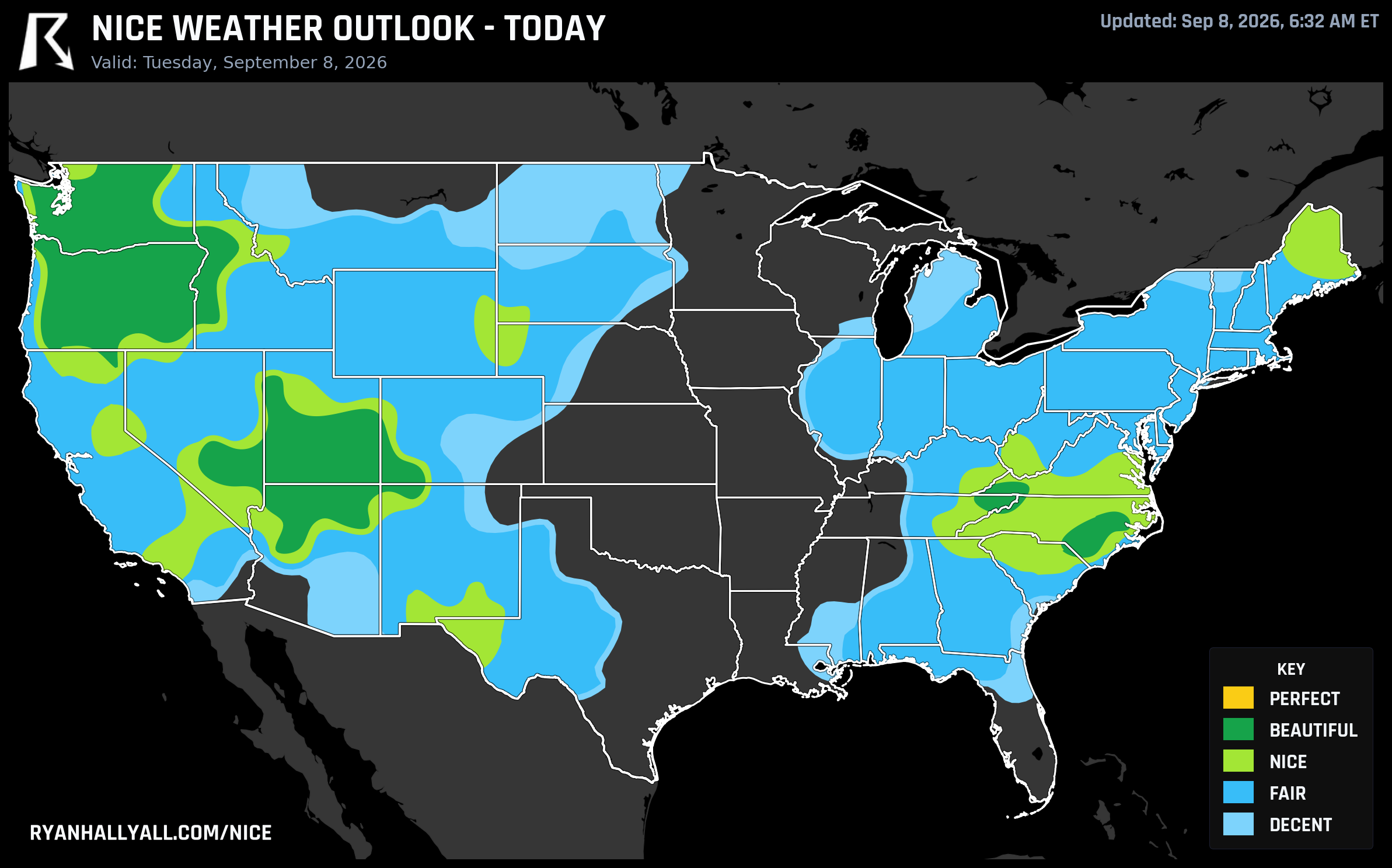
One Ridge, Three Encores: Nice Weather Rolls From the Pacific Northwest to the Rockies to the Great Lakes This Week
If you're at the Cumberland County Fair in Fayetteville, North Carolina today, or grabbing a patio table in Boise, or driving through the Tri-Cities with the windows down, you're standing in the same weather story. A dry, building high pressure system is sliding across the country this week, and it keeps handing out Beautiful-tier days to whoever is standing under it that day. Today it's the interior Pacific Northwest, the Great Basin, and the Carolina Piedmont. By Wednesday it's the northern Rockies. By Thursday it's Wisconsin and the Ohio Valley. Same ridge, different zip code, three encores.
Today: Interior Northwest, Great Basin, Carolina Piedmont
Today's best air sits in a wide, oddly-shaped band that includes Seattle, Portland, Salem, Eugene, Bend, Yakima, and the Tri-Cities in the Northwest; St. George out in Utah's Great Basin; and Fayetteville and Greenville over on the Carolina Piedmont. That zone is scoring 89 out of 100, just three points shy of Perfect, riding on light wind, dry air, and mostly clear skies. Highs run a comfortable 77 to 80 degrees across most of it, with Fayetteville warmer near 87 and Tri-Cities and St. George drier and slightly cooler.
Fayetteville's timing could not be better. The Cumberland County Fair is running there today, and the forecast is about as good as fairground weather gets this time of year, mid-80s, low humidity, and a mostly clear sky. If you're headed out, sunscreen still matters. UV runs around 6 to 7 across this whole band, and the one thing keeping several of these cities out of Perfect territory isn't wind, sky, or air quality, it's temperature sitting just a hair above the comfort threshold.
This is a good day to check the Nice Weather outlook page before you commit to plans, because the map is not uniform. The Midwest and Mid-Atlantic are stuck in Fair territory today, partly because of a real air quality problem, CAMS readings spiking near 106 in spots, and partly because Iowa and eastern Nebraska are sitting under a Slight Risk of severe thunderstorms and damaging gusts this afternoon and evening. That's not a nice weather day for that corridor, regardless of how warm and sunny it looks on paper.
Wednesday: The Ridge Moves to the Northern Rockies
By Wednesday, the best air relocates to Missoula, Anaconda, and Ontario, plus Grangeville and McCall over in Idaho. That zone scores 87, still Beautiful, driven by essentially textbook conditions: 0% rain chance, calm heat stress, and sky cover down around 18%. The catch is temperature and dewpoint run a little cool rather than ideal, highs near 73, dewpoints near 41. It's gorgeous, just not warm enough to nudge into Perfect.
The Pacific Northwest doesn't disappear Wednesday, it just steps down a notch to Nice, with Portland, Boise, Spokane, and Salem all still very pleasant in the upper 70s to low 80s. Worth noting for football fans: the Patriots visit the Seahawks in Seattle Wednesday evening, and while Seattle isn't the day's top performer anymore, conditions there stay comfortable for an outdoor kickoff.
One small caveat for the Rockies stretch: southeastern Montana and northern/eastern Wyoming carry an elevated fire weather concern Tuesday into Wednesday, gusty west winds and low relative humidity ahead of a cold front. It doesn't affect the nice-weather comfort scoring, but it's worth knowing if you're near that corridor.
Thursday: The Ridge's Best Performance, Over Wisconsin
The tour peaks Thursday. Behind this week's departing frontal system, high pressure builds in over the central Great Lakes and Ohio Valley, and Green Bay, Eau Claire, Oshkosh, La Crosse, and Wausau all land in a zone scoring 90.5, the closest any region gets to Perfect all week. Precipitation and heat stress both score essentially maxed out, dewpoints sit in the low 50s, cloud cover averages just 10%, and winds stay under 8 mph. Highs land near 76, about as close to ideal September comfort as this outlook gets.
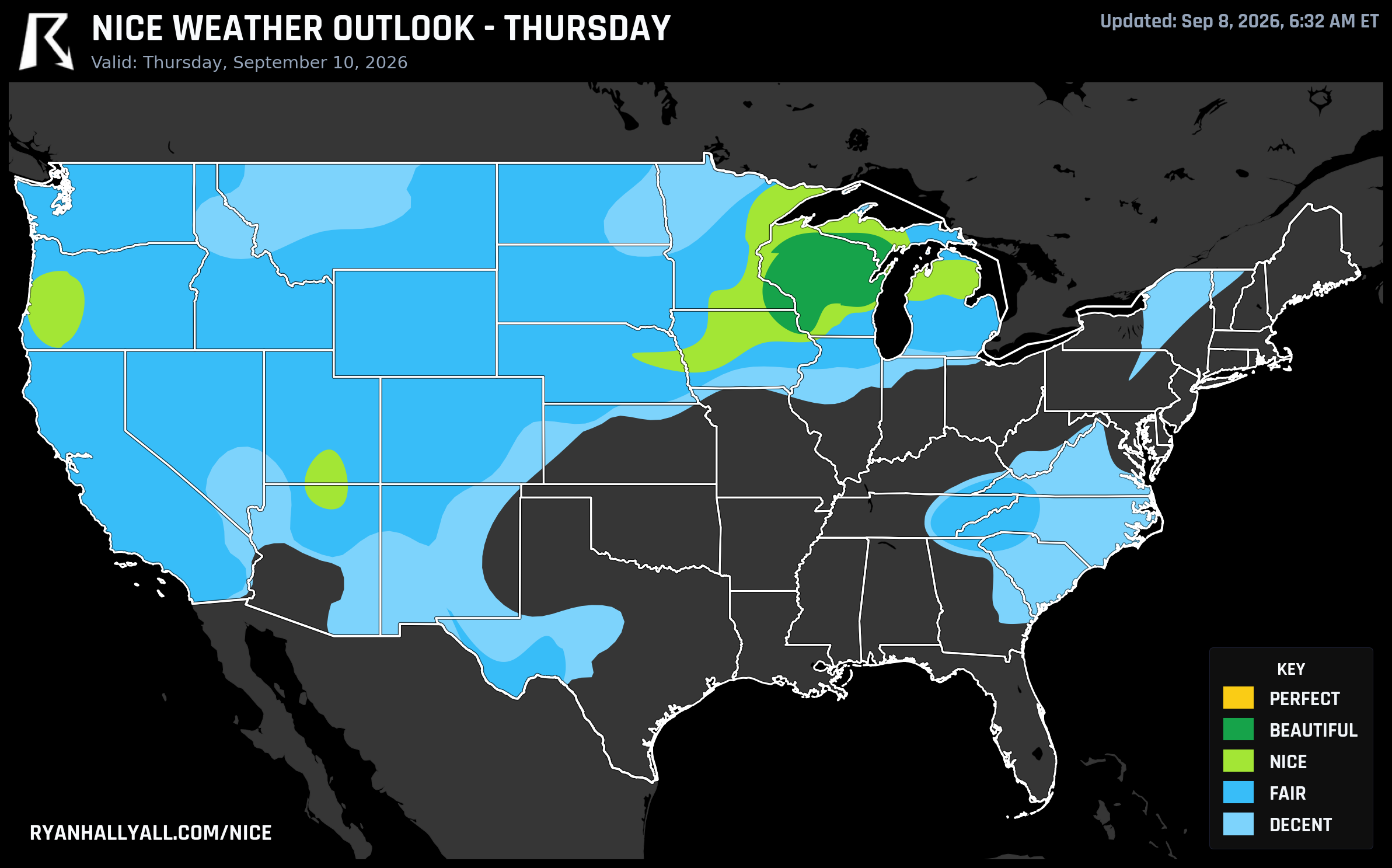
The WPC's short-term discussion explains why: strong to severe storms currently pushing through the Midwest today clear out by Thursday, and the drier air mass building in behind that front is exactly what turns southeastern Minnesota and Wisconsin into this week's showpiece. Rochester, Minnesota, and a few Wisconsin towns run slightly warmer or cloudier and land closer to 82, still a fine day, just not quite the peak.
What Happens After Thursday
Looking into the weekend, the extended discussion is honest that the ceiling drops. Days 4 through 7 cap out at Nice rather than Beautiful across the country, as a slow eastward shift in the upper-level pattern moves the best real estate from the Northeast on Friday and Saturday out to California and the Pacific coast by Sunday and Monday. None of that is bad weather, it's just a step down from this week's run of standouts, and confidence is understandably lower the further out you look. Meanwhile the Central Plains keep dealing with recurring showers, gusty winds, and periodic severe storms that pin that corridor at Decent or Fair most days, a pattern that lines up with the broader outlook's mention of a lingering heat wave and rapid onset drought risk building across the southern Plains.
So take advantage of this particular stretch while it's rolling through. Whether you're catching the fair in Fayetteville today, a scenic drive through the Bitterroot Valley Wednesday, or a walk through downtown Green Bay Thursday, the ridge is doing the same trick three times in a row. Just don't expect it to stick around past that.