Blog Article
Nice Weather Today: Western WA Beautiful, Bay Area's 90-Day Streak
Western Washington and the Carolinas post the best air today, Tucson and Spokane get their turn Friday, and the East Bay quietly hits a 90-day nice weather streak.
The Bay Area's Quiet 90-Day Streak, and a Pacific Northwest Encore Before Arizona's Turn Friday
While a good chunk of the country deals with flash flood warnings, marginal severe risk, and the kind of humid haze that makes September feel like August, two very different corners of the map are quietly having an excellent week. One of them is loud about it today. The other has been this good, or better, for three straight months and barely said a word.
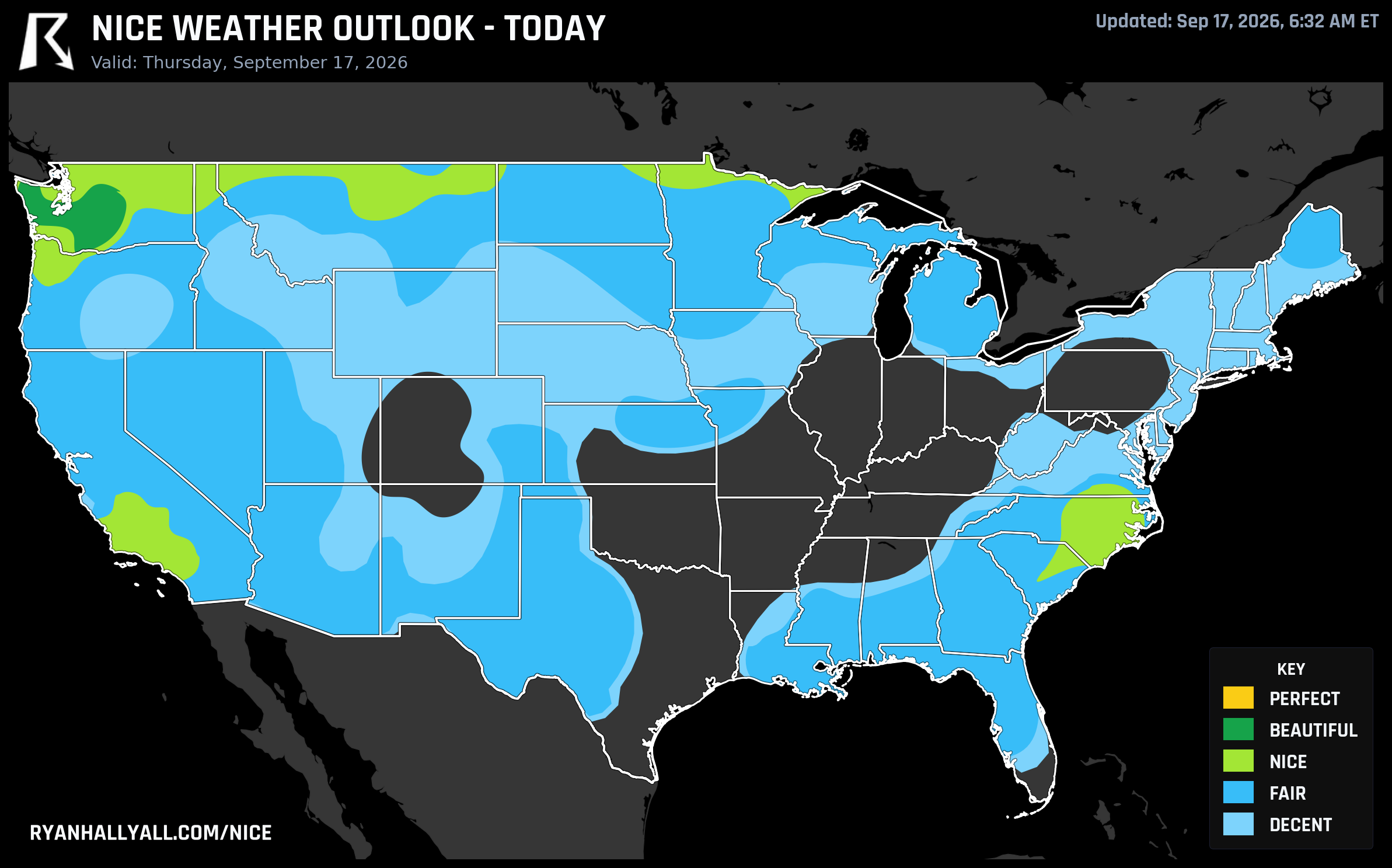
Today's best air: western Washington, again
High pressure has scoured the sky over western Washington, and it's producing the nicest numbers on the board today. Tacoma, Yakima, and Wenatchee are all sitting in Beautiful territory, with Wenatchee's dewpoint down near 43°F and cloud cover across the zone averaging just 5 percent. Highs run a comfortable 71°F on average, overnight lows dip into the mid 50s, and AirNow readings as low as 17 to 35 confirm the air is genuinely clean, not just clear. If you're doing a patio breakfast in Tacoma or a trailhead start in the Wenatchee foothills, this is about as good as September gets, though the discussion notes the zone is missing Perfect by a hair, mainly because the temperature sub-score falls just short of that top gate.
There's a second bright spot worth knowing about if you're near the Carolinas: Raleigh and Fayetteville land in the Nice tier today, and the broader Southeast, including Asheville, is dry enough to make outdoor plans easy. That matters today specifically because the Biltmore Championship is underway in Asheville, and golfers get a low-storm, manageable-humidity day to work with rather than the soggy pattern that's been soaking the eastern half of the country most of this month.
{{NICE_WEATHER_IMAGE_DAY_N}}
Friday's handoff: Tucson and Spokane share the spotlight
By Friday, the ridge pattern shifts the best air east into the Intermountain West. Tucson and Sierra Vista climb to Beautiful, riding dry post-monsoon air behind this week's flooding rains, while Spokane holds its own Beautiful reading too. It's a genuine two-region day: desert clarity in southern Arizona paired with inland Pacific Northwest clarity nearly 1,200 miles away. The catch in the desert is UV. Tucson and Catalina Foothills are both pushing an index near 7.6 to 7.7, which is enough to knock the zone out of an even higher category and enough that sunscreen and shade breaks aren't optional if you're hiking midday. Washing-out afternoon showers from earlier in the week should be gone by Friday, but anyone near recently flooded washes in southeastern Arizona should still give the terrain a look before heading out.
{{NICE_WEATHER_IMAGE_DAY_N}}
The real story: a 90-day streak nobody's been talking about
Here's the part that doesn't show up in a single day's map. According to our streak tracking, cities across the East Bay, Hayward, Concord, Berkeley, Richmond, San Leandro, Napa, Pleasanton, Union City, and more, have now logged 90 consecutive days at Nice or better. That streak runs back to mid-June and hasn't broken once. A few of those cities touched Beautiful as recently as August 29, and most saw it back on June 21. Ninety days is a full summer's worth of marine-layer mornings burning off into comfortable, dry afternoons, without a single day dropping into Fair or worse. That's the kind of consistency that rarely gets a headline because nothing dramatic happens, it just keeps being good, day after day.
It's not the only sustained run on the board. Spokane, Spokane Valley, and the tiny farm town of Green Bluff, Washington lead our weekly rankings outright, with a mean score of 84.4 to 84.5 across all seven days and at least Nice conditions every single day this week. Corvallis and Albany, Oregon aren't far behind, backed by the Willamette Valley's dry late-summer stretch, good news if you're timing a wine country weekend.
What to watch elsewhere
None of this is happening in a vacuum. WPC has a Slight Risk of excessive rainfall stacked up from the north-central Plains into the Midwest today and tomorrow, tied to a disturbance dragging tropical-origin moisture out of the Southwest. That's the same broad pattern keeping Chicago, Kansas City, and the Ohio Valley locked in Fair-to-Decent territory, mostly on cloud cover and shower chances rather than heat. The Southern Plains and Great Basin also carry elevated fire weather concern today, with RH values dropping into the 15 to 25 percent range and sustained winds adding to the risk. None of that touches the nice zones described above, but it's worth knowing why the rest of the map looks the way it does.
If you want the day-by-day national picture as this pattern evolves, the Nice Weather outlook page tracks it live, and it's worth a look again this weekend once the Arizona-to-Spokane handoff plays out and the next stretch of the forecast starts to take shape.
For now: western Washington and the Carolinas today, southern Arizona and the inland Northwest tomorrow, and somewhere in the East Bay, a 90-day streak that just keeps rolling along without asking for credit. Check the Nice Weather outlook page before you lock in weekend plans, especially if you're anywhere near that eastern rain risk.