Blog Article
Why North Dakota, Not Boise, Gets Monday's Perfect Weather
Boise and Santa Fe hit Beautiful today but can't clear air quality and UV gates. Tomorrow, five small North Dakota towns reach a true Perfect day instead.
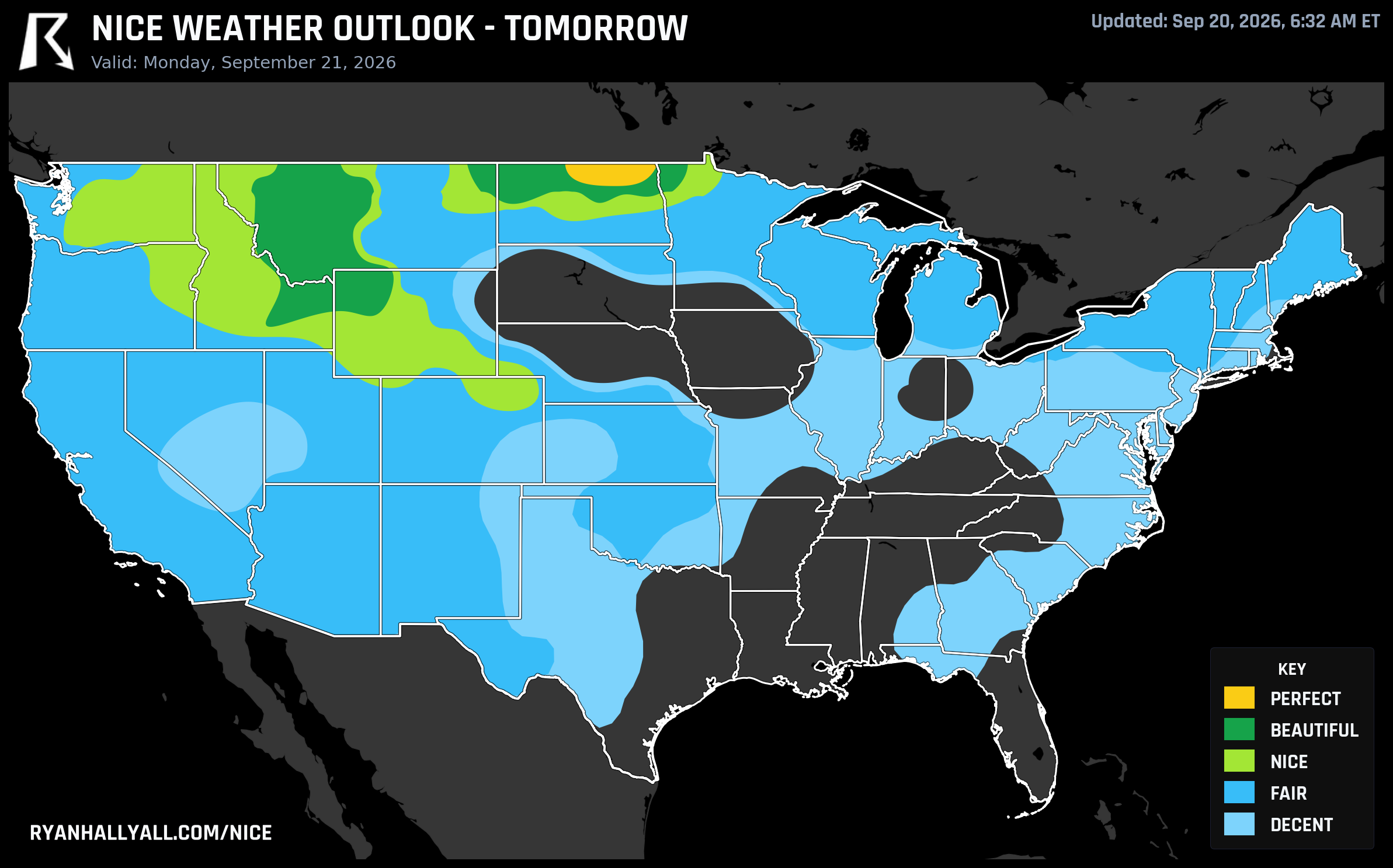
Rugby, North Dakota Is About to Have the Nicest Weather in the Country
Here's a fun contradiction buried in today's data. The best-looking weather map of the day belongs to the desert Southwest and the northern Rockies, big, well-known cities with wide-open sky and dry air. And yet none of them can climb past Beautiful today. Meanwhile, tomorrow, the actual ceiling of the scale gets reached by five towns most people couldn't find on a map: Rugby, Bottineau, Belcourt, Langdon, and Park River, North Dakota. That's the kind of thing this outlook exists to notice.
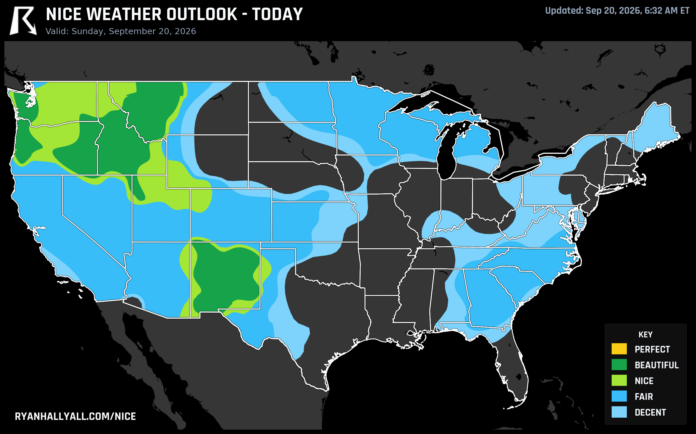
Today: Boise and Santa Fe Do Everything Right, Except Two Things
Sunday's headline zone runs from New Mexico and west Texas up through Idaho, Montana, Oregon, and Washington. Boise, Santa Fe, Las Cruces, Eugene, and Hillsboro are all sitting at 92.0, the strongest scores on the board, and the underlying numbers back it up: highs in the low-to-mid 70s, dewpoints in the mid-40s, winds under 10 mph, and just 13% cloud cover. Every individual sub-score in this zone clears 92 out of 100. On raw comfort, this is as good as it gets.
So why does the zone-wide category land on Beautiful instead of the top tier? Two numbers that have nothing to do with temperature or wind. The zone's average air quality index sits at 44, just above the stricter threshold the top category requires, and Santa Fe's UV index reads 7.2, a hair past the cutoff for that same tier. It's a good reminder that a locally perfect afternoon can still get capped by air quality or sun exposure that most people never think to check. If you're outside for hours in Santa Fe, Boise, or Albuquerque today, the sunscreen and eye protection matter more than the forecast might suggest, and folks in El Paso and Seattle specifically are dealing with a rougher air quality reading than the rest of the zone.
Tomorrow: A Tiny Corner of North Dakota Clears Every Gate
Monday flips the script entirely. High pressure builds into the northern Plains behind a departing system, and in a narrow band across north-central North Dakota, Rugby, Bottineau, Belcourt, Langdon, and Park River, the air actually does clear every threshold at once. Highs land near 68.5°F, lows dip to about 42.7°F, winds average a barely-there 7 mph, and the air quality index sits in the low 30s with a UV reading of just 5.0. Nothing here is extreme in either direction. That's the whole point. This zone scores 92.9, the top of the outlook, with no next tier to chase.
Ring out from there and the quality steps down in an orderly way. Missoula, Idaho Falls, Grand Forks, Minot, and Livingston post Beautiful conditions (89.0), just three points off the ceiling, held back mainly by highs running a couple degrees warmer and dewpoints a touch less crisp. A broader Nice-tier footprint covers Tri-Cities, Fort Collins, Great Falls, and the wider high plains, and a Fair tier stretches across the central Plains and Midwest, dragged down almost entirely by cloud cover tied to lingering moisture, not temperature or wind.
It's worth sitting with the contrast for a second. Today's best zone has ideal temperature and wind but gets nicked by haze and sun intensity. Tomorrow's best zone has nothing flashy about it at all, just quiet, clean, cool air over rural North Dakota, and that's exactly why it's the one that actually reaches the top of the scale.
Where the Good Air Heads Next
By Tuesday, the best conditions relocate again, this time to the northern Great Lakes and Upper Mississippi Valley. Minneapolis, Marquette, Brainerd, Ashland, and Cadott all land in Beautiful territory with highs near 64°F, dewpoints in the low 40s, and essentially zero rain chance. It's proper fall weather rather than warmth, so bring a jacket for the morning. Clear, calm nights in that setup also favor frost in sheltered spots, and Lake Superior stays rough enough that swimming or small-boat plans should wait. Upper Michigan towns like Sault Ste. Marie, Cheboygan, and Munising ride this same airmass through much of the coming week, quietly stacking up a solid run of Fair-to-Beautiful days even though none of them will make a top-ten headline.
Farther out, Days 4 through 7 stay narrower and messier. A ridge over the central US keeps the southern Plains warm and humid, while a slow-moving system off the East Coast keeps cloud cover elevated across the Midwest and Ohio Valley. Nice pockets persist, first over the northern Rockies and Upper Midwest, then sliding toward the High Plains and Appalachian corridor by the weekend, but nothing in that stretch approaches what North Dakota gets on Monday. Confidence on those later days is reasonable but not high, since the exact placement of that eastern system is still being sorted out.
The Fine Print Worth Knowing
None of this happens in isolation. The same Sunday pattern that's giving the Rockies their dry, sunny stretch is also feeding a slight risk of severe thunderstorms across Oklahoma and into eastern Colorado and western Kansas, plus flash flood concerns lingering in the Midwest and Ohio Valley from repeated rounds of heavy rain. If your travel plans touch either of those areas, that's the more useful forecast to be watching. For everyone else eyeing Boise, Santa Fe, or a Monday drive through the Dakotas, the air is about as easy to be outside in as it gets this week. For the full picture city by city, the Nice Weather outlook page tracks how these zones shift day to day, including which small towns like Rugby end up outscoring places ten times their size.