Blog Article
Beautiful Today, True Perfect Tomorrow: Nice Weather Outlook
Billings and Missoula hit Beautiful today, but the outlook's real Perfect ceiling gets cleared tomorrow in a cluster of small towns near the Minnesota-Canada border.
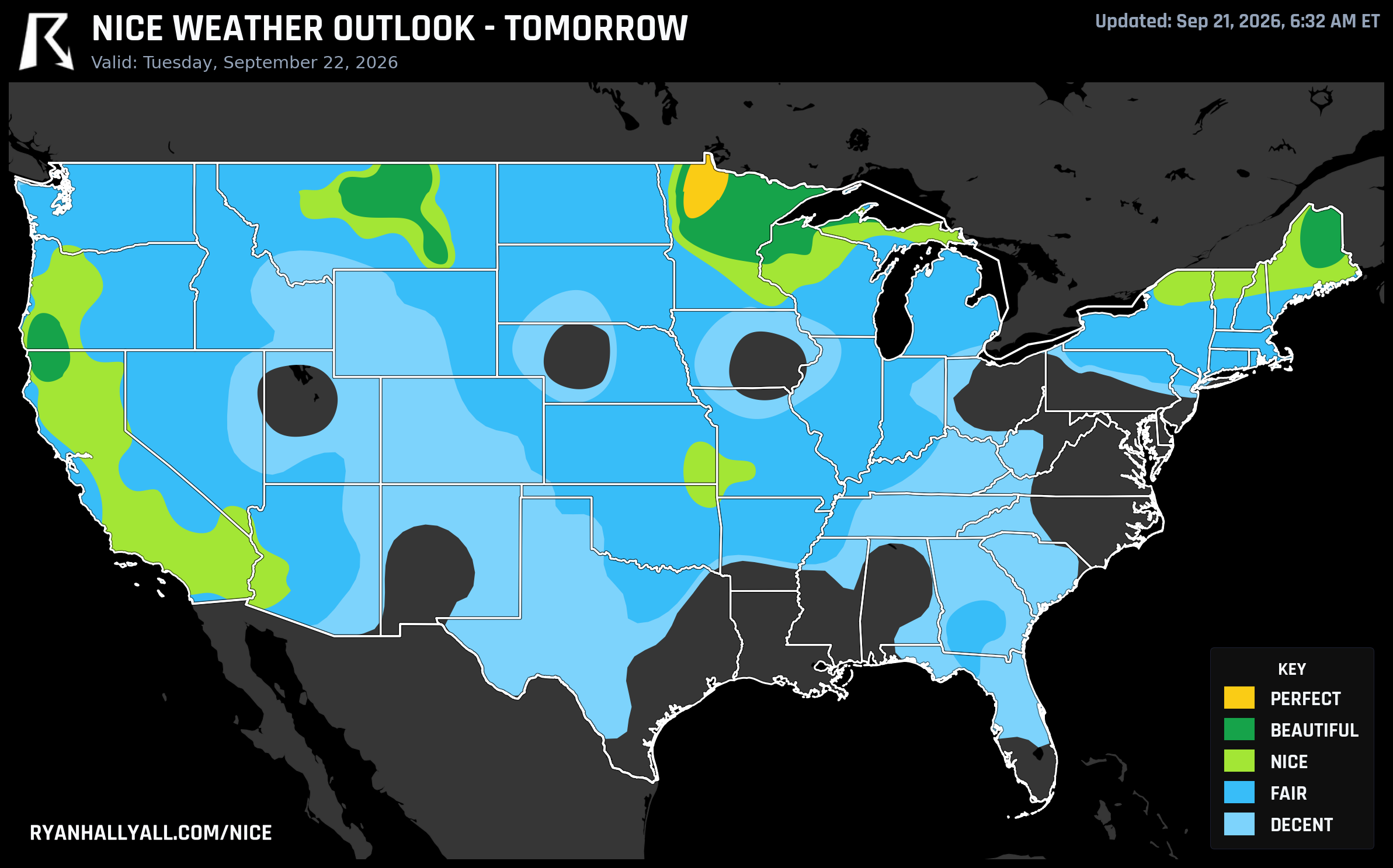
Montana Hits Beautiful Today, But the Scale's True Ceiling Waits by the Canadian Border Tomorrow
Here's the pattern worth watching this week: the nicest-looking weather on the map and the actual best weather on the map keep landing in different places. Today it's Big Sky Country doing everything right and still coming up just short. Tomorrow, the outlook's hardest tier finally gets cleared, and it happens in towns most people have never had a reason to visit.
Today: Beautiful Everywhere From the High Plains to the Northern Rockies
Monday's headline zone stretches from the central High Plains into the Northern Rockies and Inland Northwest. Billings, Missoula, Idaho Falls, Pocatello, Butte, and Las Cruces are all sitting at a score of 92.0 and a Beautiful rating, with Great Falls, Minot, and Bozeman right behind them in the low 80s. El Paso rounds out the group with warmer numbers but the same dry, settled air.
The setup is a building ridge scouring out clouds and moisture behind a departing upper low, which is why the sky is doing almost all the work: cloud cover across this zone averages just 15 percent, winds are light at 9 mph, and rain chances are essentially nil. Highs run a comfortable upper 60s to low 70s.
So why isn't this Perfect? Two reasons, and neither is dramatic. Temperature and dewpoint sub-scores both land just under the 92 threshold Perfect requires, Minot's high of 66°F and Billings' 68°F are pleasant but a touch cool for the top tier. And separately, the average air quality index of 43 sits above Perfect's strict ceiling of 35. A few degrees warmer without adding humidity, plus slightly cleaner air, would be the whole difference. Even a couple of far northern North Dakota towns, Walhalla, Pembina, and Cavalier, posted scores north of 98 today and still landed at Beautiful rather than Perfect for the same gate reasons. This system cares about clearing every box, not just piling up points.
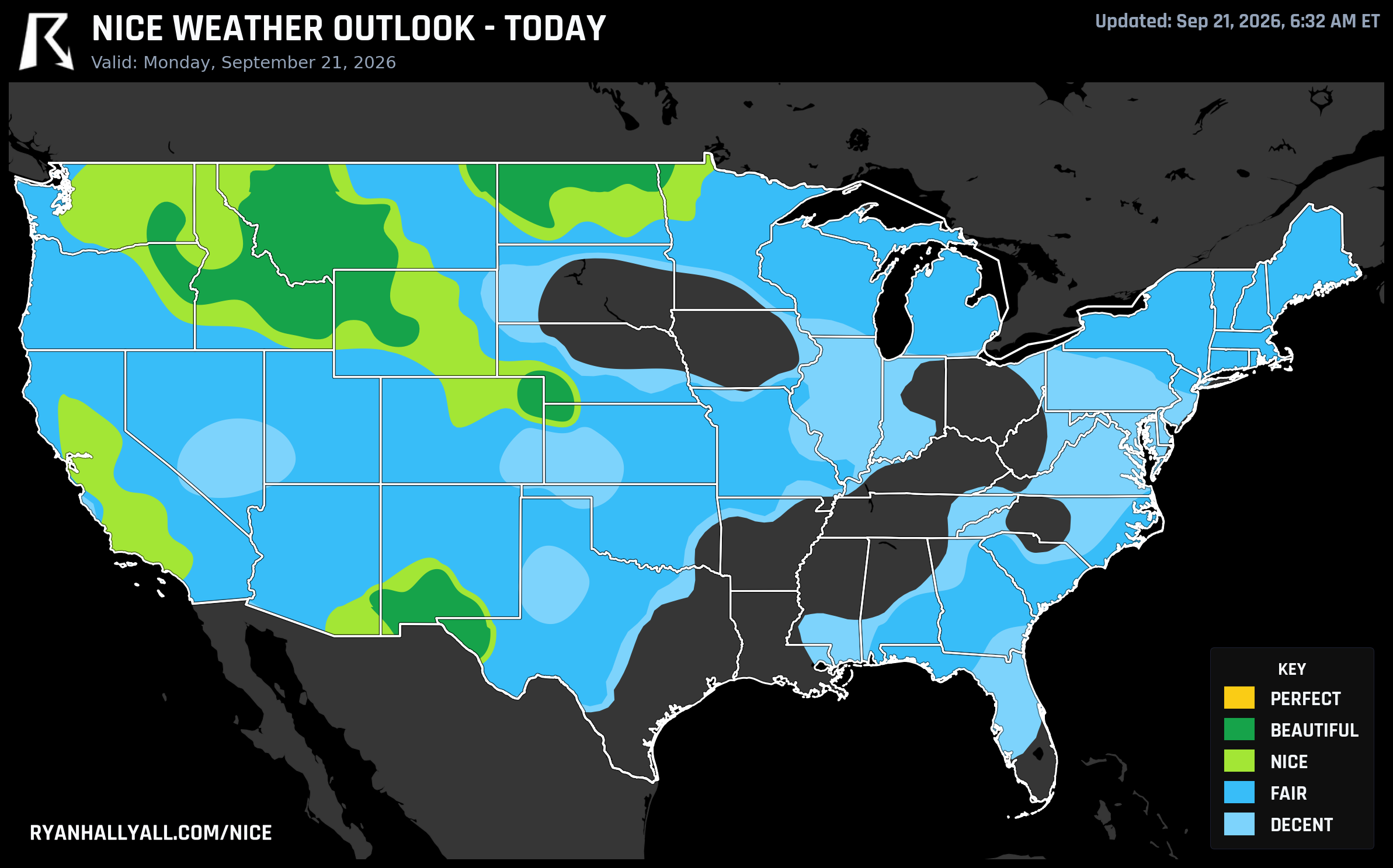
One caveat if you're farther west: Los Angeles, San Francisco, Seattle, and Denver are pleasant on temperature and wind today but capped at Nice because of smoke and haze drifting in from the coast, with air quality readings spiking as high as 140 CAMS AQI in spots. Nothing dangerous for most people, but worth knowing before a long outdoor day.
Tomorrow: The Real Ceiling Shows Up in Far Northern Minnesota
Tuesday is where this week's pattern actually peaks. A building ridge and a departing surface high settle over the northern Plains and Upper Midwest, and one small pocket clears every single gate the outlook has: Baudette, Bemidji, Roseau, Fosston, Ponemah, Blackduck, Red Lake, Redby, Little Rock, Naytahwaush, and Bagley, all tucked into the Red River Valley and Red Lake area of far northwest Minnesota. Scores there run from the mid-90s up to 99.0, temperature, dewpoint, sky, wind, precipitation, and heat stress sub-scores all clear 92, and the air quality index sits at a clean 34. That's Perfect, the actual top of the scale, not the near-miss version.
Expect highs only in the low 60s with lows near 40, so patchy frost is possible at daybreak, dress in layers for the first outdoor hour and you'll be fine by midday. Cloud cover averages just 7 percent, rain chances are 0 percent, and winds stay light. It's about as clean a fall day as this outlook produces, cool enough to need a jacket at sunrise and calm enough to enjoy every hour after that.
Just south and around that pocket, a broader Beautiful band covers the northern Plains, Upper Midwest, northern Rockies, and northern New England, Medford, Oregon; St. Cloud, Minnesota; Presque Isle, Maine; and Lewistown, Montana all score in the low 90s with highs near 67°F. A wider Nice band reaches Los Angeles, Portland, Sacramento, Minneapolis, Bakersfield, Riverside, Stockton, and Henderson, though Los Angeles again gets held back slightly by UV near 7 and lingering haze.
It's a neat bit of continuity, too. The last two days running, the outlook's true top tier has belonged to tiny towns strung along the Canadian border, first in North Dakota, now sliding east into Minnesota's Red Lake country. If you're chasing the single nicest afternoon in the country this week, that's where it is, even if you'd never have guessed it from a map of famous places.
A Regional Note for Golf Fans in Arkansas
Midweek, the same building ridge pushes the good weather south and east. By Wednesday, Fort Smith and Fayetteville, Arkansas are both sitting at Beautiful, Fort Smith scoring a full 92.0 with highs near 90°F but dry, calm air keeping it comfortable. That's good timing for anyone tracking the Walmart NW Arkansas Championship pres. by P&G, which arrives in the region this week, dry skies and light wind are exactly what you want trackside or at the tee box.
The Longer View: California and the Central Valley Keep Their Streak Going
Zoom out to the whole week and a familiar name tops the list: Sault Ste. Marie, Michigan posts the best 7-day average score in the country, peaking near 92 on Tuesday. Right behind it, a run of Central Coast California towns, Santa Maria, Nipomo, Guadalupe, and San Luis Obispo among them, hit Nice or better on all seven days, anchored by that same Tuesday ridge.
Further inland, it's less a streak of good luck than a whole season's worth. Fairfield, Vacaville, Napa, Sacramento, Stockton, Elk Grove, Roseville, Vallejo, and a dozen other Sacramento Valley and Bay Area cities are riding 90-day streaks of Nice-or-better weather, essentially the entire measured summer. If you want a place where the odds have simply favored good weather since June, that corridor is it. You can track how these streaks and daily scores evolve on the Nice Weather outlook page.
What to Watch Elsewhere
None of this is happening in a vacuum. The central Appalachians and Mid-Atlantic are under a Moderate excessive rainfall risk into Tuesday night, with soil already saturated from recent storms, not a place for outdoor plans this week. A slight severe thunderstorm risk also lingers over the Southeast into the southern Appalachians today and tomorrow. And out in New Mexico and West Texas, a slight risk of excessive rainfall reflects an active Southwest monsoon that will start showing up in El Paso's numbers again by midweek, a reminder that even a normally reliable desert city can have a soggy stretch.
Looking toward the weekend, the outlook's daily rules cap every zone at Nice through Days 4 through 7 regardless of raw score, and the best pockets bounce around, California cities cluster near the top most days, with Buffalo, Salt Lake City, Charlotte, Milwaukee, and Atlanta taking turns in the mix. Confidence drops the farther out you look, but the broad shape holds: warm, mostly dry, and cloud cover doing more damage to the scores than heat ever does. Keep an eye on the Nice Weather outlook page as those daily pockets shift.
For now, though, the story is simple. Montana and the High Plains earned a genuinely lovely Monday. Northwest Minnesota gets the one this scale was built to reward.