Blog Article
Nice Weather Outlook: Perfect Day Hits Wisconsin's Northwoods Sept 23
Sacramento's 90-day nice weather streak peaks today, but Wednesday is the only day this week that reaches Perfect, in Wisconsin's Northwoods and Michigan's UP.
Sacramento's 90-Day Streak Peaks as Wisconsin's Northwoods Claim the Week's Only Perfect Day
Somewhere on a patio in Sacramento this morning, somebody is eating breakfast in air that has been consistently good since late June. That's not a figure of speech. Sacramento, Stockton, Elk Grove, Roseville, Vallejo, Napa, Davis, Woodland, Folsom, Lodi, Tracy, Manteca, Carmichael, Rancho Cordova, and a long list of their Central Valley and Bay Area neighbors are all riding a 90-day streak of Fair-or-better weather, and today several of them cap it off by touching Beautiful again. That's the kind of streak you don't notice until someone points at the data and says, huh, that's been going on since before the Fourth of July.
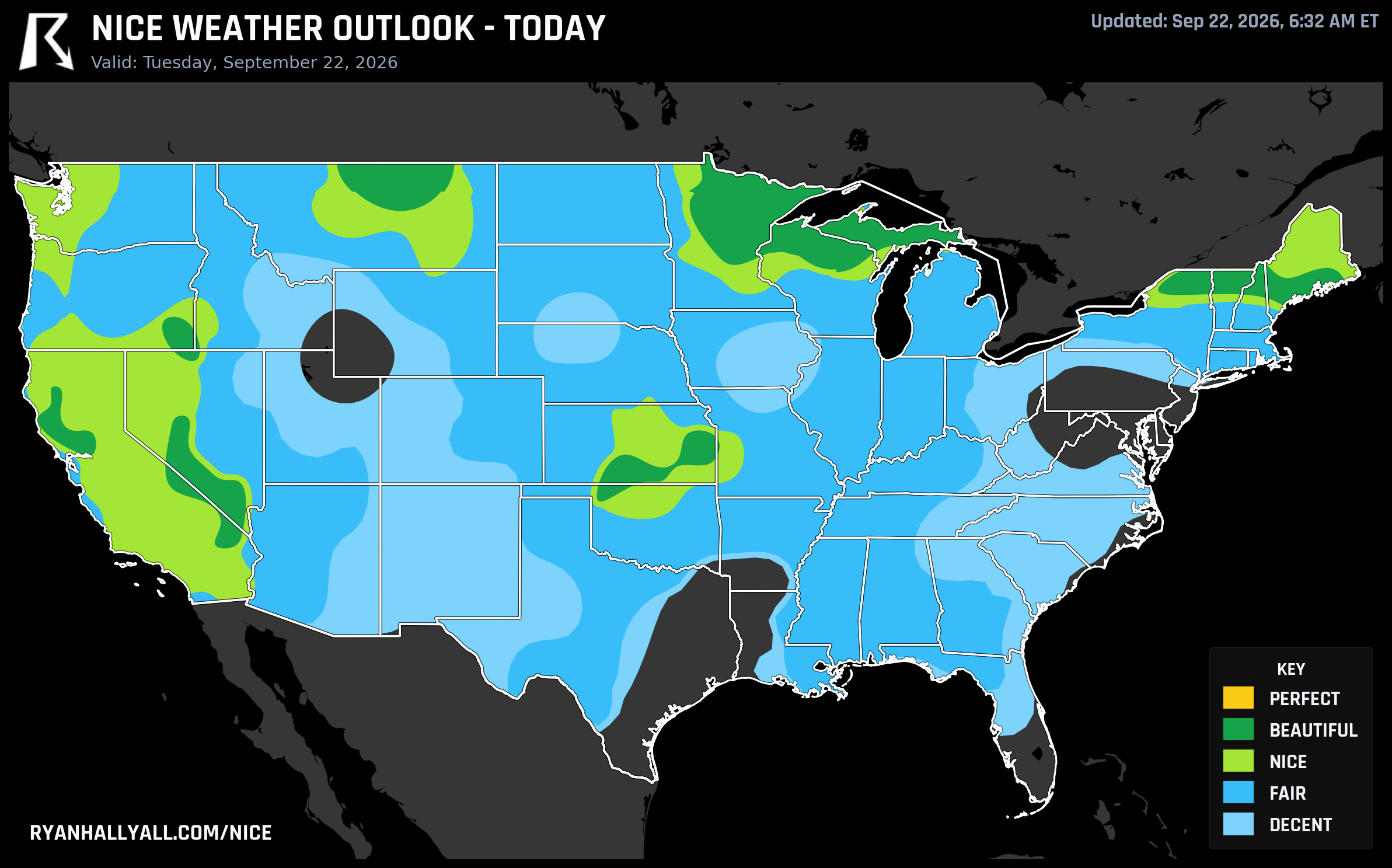
Today: A Beautiful Corridor, and the Valley's Quiet Win
Tuesday's best weather sits under a Canadian high pushing into the northern Plains, Upper Midwest, and interior Great Basin. Las Vegas, Sacramento, Wichita, Lawrence, Napa, St. Cloud, Burlington, Pahrump, Lewiston, and Bangor all land in Beautiful territory, with scores from the low 70s up to a clean 92. The zone's numbers explain why: highs near 69 degrees, dewpoints around 47, just 17 percent cloud cover, and rain chances near 1 percent. Winds stay light, around 9 mph with gusts to 16.
According to the discussion out of the Y'all Squad Weather House, this zone gets within about two and a half points of the outlook's top gate today but doesn't quite clear it, mostly because highs in spots like St. Cloud and Burlington run a touch cool for peak comfort. Sacramento doesn't have that problem. With a high near 87 and low humidity, it's warm enough to sit outside all afternoon and still cool enough at night to sleep with a window cracked, which is exactly the recipe that's kept its streak alive for three straight months.
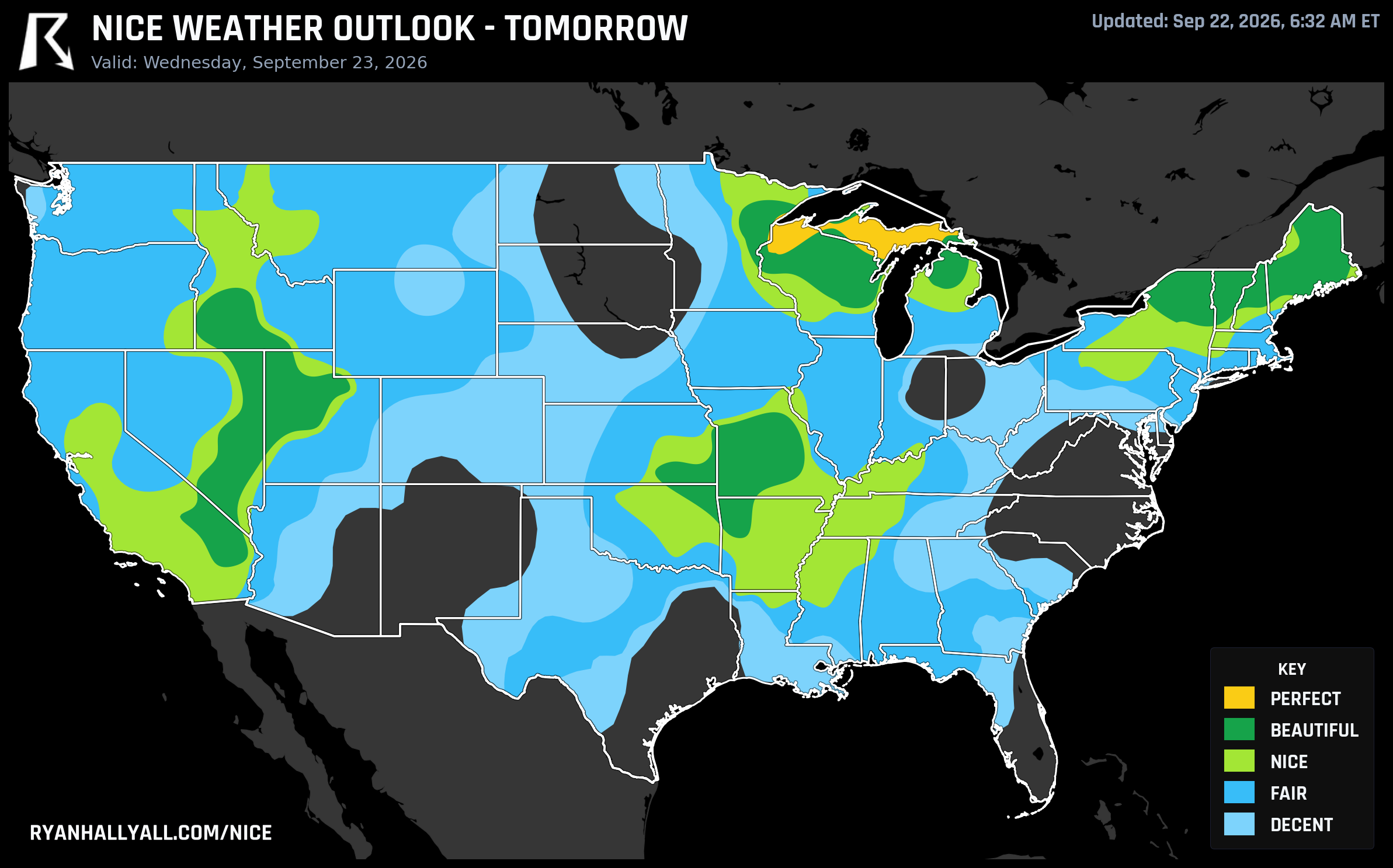
Wednesday Is the Only Day That Actually Touches Perfect
Here's the detail worth circling on your calendar. Out of the entire seven-day outlook, only one day and one small stretch of the country actually clears the scale's top category, Perfect. It happens Wednesday, September 23, across northern Wisconsin and Michigan's Upper Peninsula, in towns like Superior, Marquette, Ironwood, Newberry, and Clam Falls.
The numbers there are close to as clean as this system allows. Highs run 62 to 66 degrees under just 3 percent cloud cover, with a 0 percent rain chance, dewpoints near 47, and an AQI in the mid-30s with zero modeled smoke. Individual city scores push into the high 90s and even the upper 99s in a handful of towns. It's crisp, dry, quiet fall air, the kind where a hike feels effortless and a lake still holds enough afternoon warmth to fool you into thinking about a swim, right up until you touch the water and remember it's September in Lake Superior country.
The rest of Wednesday's map is strong too, just not quite that strong. Kansas City, Boise, Salt Lake City, Spring Valley, Springfield, Columbia, Green Bay, Fort Smith, Fayetteville, and Oshkosh all land at Beautiful. Interestingly, that broader zone's underlying scores are close enough to Perfect on paper that it's tempting to think it's just a numbers gap. It isn't. The zone's regional AQI runs around 40, and the top gate requires 35 or better. A perfectly good score still can't buy its way past a hard air quality gate, which is a useful reminder that the categories aren't just about temperature and sunshine.
Why This Setup Works, and Where It Doesn't
The engine behind both days is the same broad Canadian high sliding across the northern tier of the country, drying out the air and knocking cloud cover down into the teens and single digits in the best spots. That's the same reason Sacramento's streak has held up so long: a persistent dry pattern that keeps rain and humidity out of the picture for weeks at a stretch.
But it's worth knowing what that high isn't fixing. WPC has a Moderate Risk of excessive rainfall posted for southern and central New Mexico and far West Texas through midweek, with tropical moisture and a stalled upper trough raising real flash flood concerns in burn scar terrain. The Southeast carries a Marginal severe thunderstorm risk today as a front pushes south. And down along the Gulf Coast, heat and humidity keep spots like Houston capped at Decent no matter how clear the sky looks, since apparent temperatures near 100 degrees simply overwhelm the comfort math. A little smoke is also worth flagging in the otherwise clean Beautiful zone today, with about 1 percent of it carrying surface smoke readings above 25 micrograms per cubic meter, and Seattle picking up light haze of its own.
Thursday Holds the Line, Then the Ceiling Drops
Thursday keeps the good stuff going as the same Canadian high shifts toward the Northeast and Mid-Atlantic. Buffalo, Rochester, Syracuse, Albany, Portland (Maine), Utica, Nashville, St. Louis, Clarksville, and Bowling Green all reach Beautiful, with highs near 69 and dewpoints near 48. Day 3 is capped at Beautiful by the outlook's own confidence rules, so even a flawless number can't push higher there, but a flawless number is still a flawless number.
From Friday through the weekend and into early next week, the ceiling drops to Nice as forecast confidence fades with distance. That corridor keeps rotating: San Diego, San Jose, Sacramento, Charlotte, Nashville, and Louisville lead Friday; Washington, Jacksonville, Columbus, Las Vegas, and Raleigh take over Saturday; Los Angeles, San Diego, San Jose, Charlotte, and Raleigh carry it into Sunday; and by Monday, Los Angeles, Chicago, Philadelphia, San Diego, San Jose, Jacksonville, San Francisco, Charlotte, Washington, and Milwaukee all sit at Nice. Dallas, gearing up for the State Fair of Texas opening that Friday, sits right at the edge of that Nice-to-Fair line, decent fair weather but worth watching afternoon cloud cover and a few percentage points of rain chance.
The bigger caution for the weekend is the coast. WPC's extended discussion has an upper low stalling near the Mid-Atlantic and Northeast, supporting a meandering coastal storm with strong onshore winds, coastal flooding, high surf, and rip currents into the weekend. That's a real concern for anyone headed to Oceans Calling in Ocean City, Maryland on the 25th. Even if the temperature reads fine, exposed beaches and boardwalks are not the place to be if that low behaves the way the models expect.
The Bottom Line
If you want the single best day and place this week, it's Wednesday in the Wisconsin Northwoods and Michigan's Upper Peninsula, hands down. If you want dependable, low-drama comfort with a bit more warmth, today's Beautiful corridor from Las Vegas to St. Cloud, plus Sacramento's ongoing streak, is the safer bet. And if your plans involve a beach on the Atlantic coast this weekend, keep an eye on the surf report right along with the forecast. For the daily rundown of where the country's best air actually is, the Nice Weather outlook page tracks all of this in one place, updated as the pattern shifts.