Blog Article
Ohio Valley to Carolinas: A 3-Day Beautiful Weather Streak
Columbus, Lexington, Greensboro, and Fayetteville are stacking three straight Beautiful weather days. Here's why AQI, not the forecast, is the only thing holding them back.
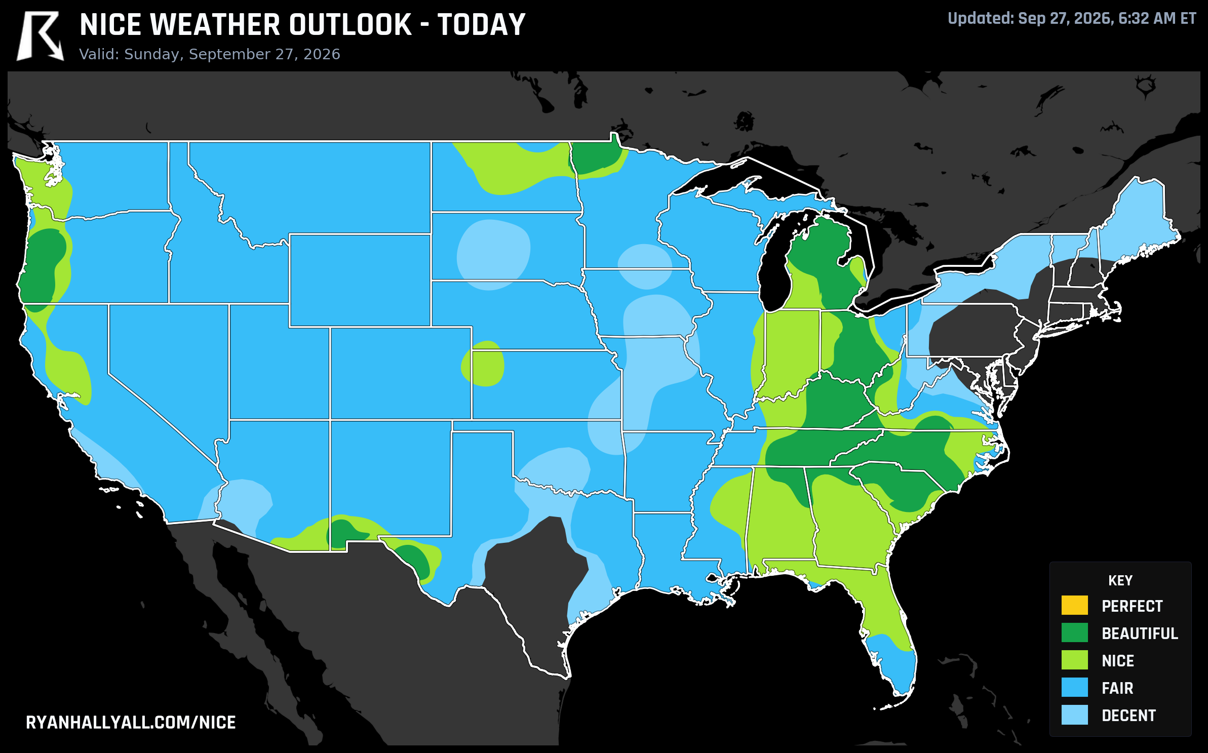
Columbus to the Carolinas Just Ran Off Three Straight Beautiful Days
While a nor'easter keeps grinding at the coast and the Southwest braces for a soggier mid-week, there's a quieter story sitting in plain sight over the Ohio Valley and the Carolinas: the same handful of cities have been sitting at Beautiful, our second-highest category, for three days running. Columbus, Lexington, Greensboro, Fayetteville, and a few neighbors keep posting a 92.0 score day after day, and the numbers behind that streak are almost comically clean.
What's actually happening
High pressure has settled in over the Ohio Valley and mid-South, and it's just sitting there, refusing to budge through Tuesday. That means light winds, minimal cloud cover, and dewpoints in the 50s instead of the swampy 60s and 70s you'd expect from late September in the South. Sunday's Beautiful zone averaged a 75.6°F high, a 49.9°F dewpoint, just 9 percent cloud cover, and winds barely above 9 mph. Monday looked almost identical, and Tuesday's version of the same air mass pushed highs into the low 80s in spots like Lexington while keeping the sky just as clear.
Here's the part that's genuinely interesting if you like the mechanics of this stuff: on all three days, the composite numbers in this zone actually clear the bar for Perfect. Temperature, dewpoint, precipitation, wind, and sky sub-scores are all sitting in the mid-90s to high-90s out of 100. The single thing standing between this corridor and the top category is background air quality, running in the mid-40s to low-50s AQI, just above the strict ceiling required for Perfect. It's not smoke, it's not haze from any specific fire, it's just the kind of quiet particulate load that settles into a stagnant high pressure system. If you're outside all day, it's not something you'll notice. If you're sensitive to air quality, it's worth knowing the ceiling is there.
The run of near-92 scores has been remarkably consistent by city too. Columbus, Lexington, Greensboro, Fayetteville, and Meads, Kentucky, have each posted a 92.0 on all three days so far. Nashville, Cincinnati, and Charlotte have been right there with them. Billings, Montana joined the party on Tuesday as the ridge stretched an outpost of the same calm, dry air into the northern Rockies.
The one caveat worth knowing
That same dry high pressure that's producing gorgeous afternoons is also drying out the ground. Relative humidity has been dipping into the 20s and low 30s across Alabama and Kentucky during peak afternoon hours, which is enough for local fire-weather concerns even without any wind to speak of. If you're grilling, having a campfire, or flicking a cigarette out a car window anywhere in that stretch, it's worth being a little more careful than usual. UV has also been running a moderate 5.5 to 6.0, so a midday walk without sunscreen will still catch up with you even though the air feels cool and dry.
Everyone else's week
This corridor is the exception, not the rule, right now. A nor'easter has been parked off the Mid-Atlantic since the weekend, dragging coastal flooding and lingering rain into the I-95 corridor through Monday, which is bad timing for anyone at Sunday's All Things Go festival grounds in Columbia, Maryland. Farther west, moisture tied to what's left of Hurricane Polo is setting up a much bigger story mid-week: WPC has Moderate risk excessive rainfall flags across the Southwest and Southern Rockies Monday and Tuesday, spreading into the southern High Plains by Wednesday. That's a real flooding threat, not a nice-weather footnote, and it's the headline elsewhere on the site today.
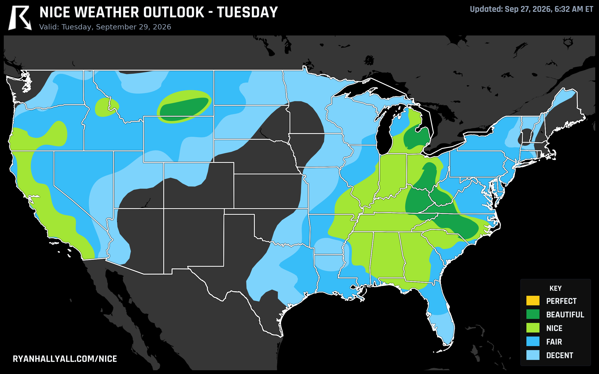
What changes by midweek
According to the extended discussion covering Days 4 through 7, the whole pattern shifts. The ridge of high pressure that's been anchoring this Ohio Valley/Carolinas run slides west into the Intermountain West and northern Rockies, and every zone in the country gets capped at Nice instead of Beautiful for the rest of the outlook period, no matter how clean the sky and precipitation numbers get. A slow-moving frontal boundary takes over the Midwest and East starting Wednesday, spreading clouds, isolated showers, and some gusty wind through the weekend. The next round of really pleasant weather migrates toward Los Angeles, San Diego, Phoenix, and the interior Southwest by Wednesday and Thursday, though those days come with lower confidence than what's already locked in for the Ohio Valley through Tuesday.
If you've got outdoor plans in Columbus, Lexington, Nashville, Charlotte, Greensboro, or Fayetteville before Wednesday, this is about as good as September gets there. Patio dinners, ballgames, trail runs, whatever's on the list, Tuesday is your last clean shot before the pattern turns over. For the day-by-day breakdown and city-level scores, the full Nice Weather outlook page tracks all seven days as the picture updates.