Blog Article
Catskills Peak Today, San Diego Wins the Whole Week
Today's nice weather data shows Catskills and Hudson Valley towns hitting the week's highest scores, while San Diego posts a perfect 7-for-7 Nice-weather week nationwide.
The Catskills Just Had Their Best Weather Day of the Week, and San Diego Never Had a Bad One
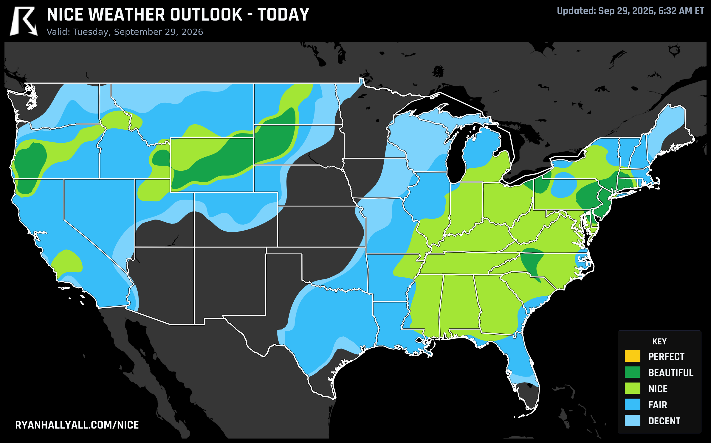
Some days in this dataset are close calls. Today is not one of those days. Out of every city we track, more than ten thousand of them are logging their single best score of the entire week today, September 29. The next closest day, a week from now, doesn't come close. When the data lines up that lopsided, it's worth asking where all that good weather actually landed, and the answer is oddly specific: a corridor of small towns tucked into the Catskills, the Hudson Highlands, and the northwest corner of Connecticut.
Where the Week Peaked
Rock Hill, New York, posted a 98.3 today, the single highest score in the country. Right behind it: Otisville (97.9), Ellenville (97.7), Wurtsboro (97.7), Woodridge (97.7), Port Jervis (97.6), Sparrow Bush (97.4), Napanoch (97.3), and Wawarsing (97.2), all clustered in Sullivan and Ulster counties. A little further east, Litchfield County, Connecticut chips in with New Preston (97.1), Woodbury (96.7), and Kent (96.7). Malvern, Pennsylvania and Eden, New York both crack 96.6-97.1 too. This is not a coincidence of geography. It's a weakening coastal low finally clearing New England, with building high pressure scrubbing out the humidity behind it.
WPC's short-term discussion says the Nor'easter parked over Cape Cod is losing steam and sliding out over the Atlantic through Wednesday, and that departure is exactly what's opening the door for this stretch of clear, dry, cool air. Today's regional AFD summary backs it up: the best-performing zone, spanning the interior Northeast, Great Lakes, and pockets of the interior Northwest, runs highs near 71°F, lows near 50°F, and dewpoints hovering around 50°F. That's about as close to ideal patio-breakfast, leaf-walk, farmers-market weather as this scoring system produces, even if the numbers stop just short of clearing the gates for our top Perfect tier.
Big cities are cashing in too, just with slightly less drama. Philadelphia leads the major-metro pack at 92.0, tied with Winston-Salem, Bridgeport, Allentown, and Erie, all sitting in the Beautiful category. Philadelphia's specifics look almost engineered for a nice day: 72.6°F high, 62.1°F dewpoint, only 31 percent cloud cover, and an AQI of 43. Manhattan and Charlotte trail just a touch behind at 82.0 and 81.9. If you're anywhere in this belt today, this is the day to actually use the outdoor plans you've been putting off.
The one place skipping the memo is the Southeast, where a strengthening ridge is pushing highs into the upper 80s and low 90s, warm enough that the comfort math doesn't work even with manageable humidity. And a little further west, San Antonio's 73.6°F dewpoint is driving its heat index to 98.2°F, a reminder that not every warm afternoon in the data is a pleasant one.
The Quiet Winner: San Diego's Perfect Week
While the Northeast is having its one loud, spectacular day, San Diego is doing something less flashy but arguably more useful: it's the only major metro area posting Nice-or-better conditions on all seven days of this outlook. The weekly rankings put San Diego at the top of the list with a 79.7 mean score across the week, and it's not alone. Poway, Encinitas, La Mesa, El Cajon, Santee, Escondido, and more than a dozen other San Diego County communities all land in the top 25 with nearly identical numbers. Their best single day arrives on Day 6 (October 4) at 82.0, but the real story is that none of the other six days dip out of Nice territory either. If you're trying to plan an outdoor event two or three weeks out and don't want to gamble, San Diego's the safer bet over any single dramatic peak.
Tomorrow's Handoff: East to West
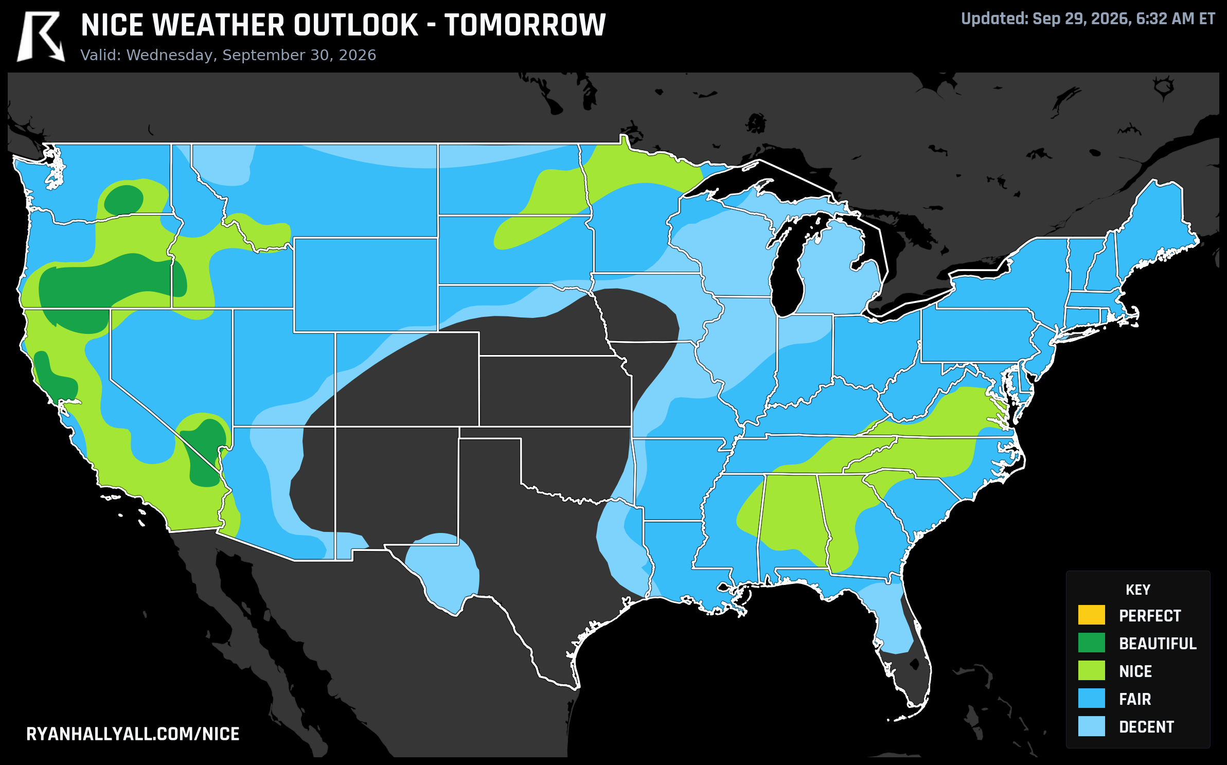
By Wednesday, the best air shifts to the Intermountain West. Las Vegas, Tri-Cities, Medford, Davis, and Pahrump all reach Beautiful-tier scores of 92.0 as a departing trough gives way to building ridging and drying air. Dewpoints there drop into the mid-40s, and skies clear to around 11 percent cloud cover, which is about as dry and clean as this pattern gets. The catch: this is the same ridge that's tightening offshore wind gradients across Santa Barbara, Ventura, and the mountains and foothills around Los Angeles, where gusts of 35 to 45 mph and relative humidity in the 15 to 25 percent range are keeping fire weather elevated even on an otherwise pleasant stretch. Worth knowing if your nice-weather plans in Southern California involve anything near the hills.
What to Watch Past That
The extended data through Day 7 stays capped at Nice, mostly because of how the forecast-day ceiling rules work this far out, not because the air mass itself is lacking. Wind becomes the main limiter by Thursday and Friday as the ridge tightens, and by Day 7 a small re-expansion of severe gust coverage in the Fair zone hints the pattern is loosening up again. Farther south, WPC's excessive rainfall outlook keeps a Moderate Risk parked over the Southwest and southern Plains for the next several days as tropical moisture from Hurricane Polo's remnants continues to stream north, a genuinely different story from the dry, comfortable stretch up in the Rockies and High Plains. And if you're the type who plans two weeks out, CPC's hazard outlook flags a slight risk of much-below-normal temperatures and a possible first frost across the Northeast, southern Great Lakes, and Ohio and Middle Mississippi Valleys around October 6-7, still far enough out to hold loosely, but a sign that this mild run won't last forever.
For the day-by-day maps and city-level detail behind all of this, the Nice Weather outlook page has the full breakdown, including where your own town stacks up this week.