Blog Article
Perfect-Tier Weather Hits Iowa Today, Buffalo and Albany Tomorrow
A rare Perfect-tier air mass sits over Iowa today and the Northeast/Great Lakes tomorrow, with a breezier Balloon Fiesta opener and a Beautiful-tier Sunday across the Plains.
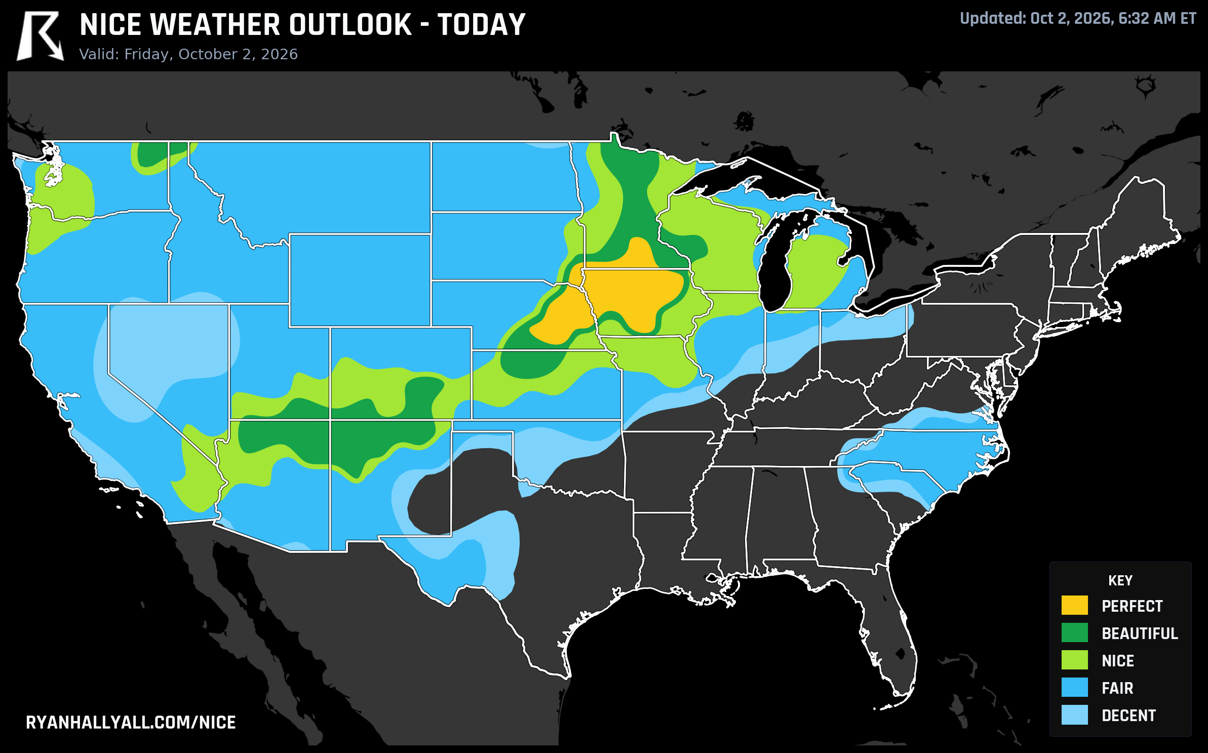
Iowa Gets the Real Perfect Score Today, Buffalo and Albany Inherit It Tomorrow
The outlook only lets the top category, Perfect, appear on two days this week. Today is one of them, and tomorrow is the other. That's worth pausing on, because most days the "best weather in the country" headline is really just the nicest version of a middling pattern. This week it's the genuine top of the scale, and it's visiting two very different parts of the country back to back.
Today: Eastern Nebraska and Iowa Own the Ceiling
A dry, post-frontal high is parked over the central Plains and Upper Midwest, and it's producing honest-to-goodness Perfect scores in Omaha, Des Moines, Sioux Falls, Sioux City, Waterloo, Grand Island, and Mankato. Des Moines is sitting at 98.9, Waterloo at 99.1, Sioux Falls at 98.3. The numbers behind that are almost absurdly clean: highs near 60 to 63 degrees, dewpoints around 48, cloud cover at 8 percent, winds a light 8 mph, and an AQI of 34. Nothing in that list is a compromise. It's a patio-breakfast, long-walk, no-jacket-needed-by-noon kind of day across the Iowa/Nebraska/South Dakota corridor.
Ring out from that core and the ceiling eases into Beautiful territory across a much broader stretch of the High Plains and interior West, including Minneapolis, Rochester, Lincoln, Saint Paul, Pueblo, and Colville. Those spots are still excellent, just a shade warmer or breezier, with Pueblo and Gallup both reading a trace of surface smoke that nudges their air quality just past the Perfect-tier cutoff.
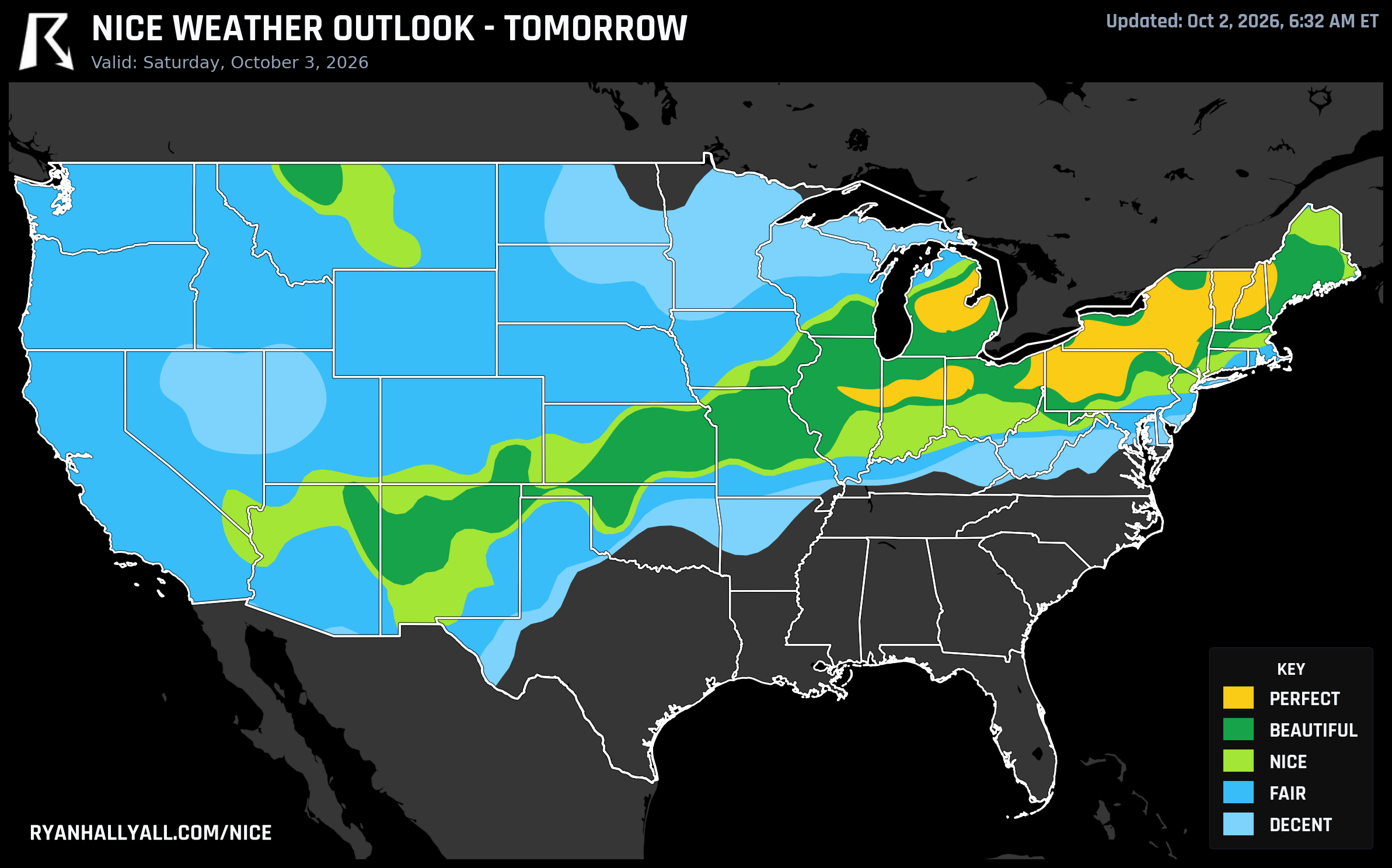
Tomorrow: The Same Air Mass Resurfaces Over the Northeast and Great Lakes
Saturday, the Perfect tier reappears, but it's picked up and moved almost a thousand miles east. Buffalo, Albany, Fort Wayne, Erie, Flint, Lansing, Grand Rapids, Syracuse, Champaign, and Bloomington all land in that top category behind a clearing high pressure system sliding through the Mid-Atlantic and Great Lakes. Buffalo comes in at 98.7, Albany at 98.5, Fort Wayne at 99.4. Highs run near 59 to 63 degrees, dewpoints in the mid-40s, cloud cover around 5 percent, and AQI a clean 32. If you've got leaf-peeping, a farmers market run, or a long bike ride planned anywhere from western New York through the Ohio Valley tomorrow, this is the day.
One honest caveat: lows dip into the mid-40s with some sheltered valleys and higher elevations flirting with frost, so an early start means a real jacket, not just a light layer.
A Word of Caution for Balloon Fiesta
Saturday is also opening day for the Albuquerque International Balloon Fiesta, and Albuquerque's weather that day is good, not great. It sits in the tier below Perfect and Beautiful, pulled down mainly by wind, with afternoon gusts near 24 mph in the model data. That number reflects the warmer part of the day rather than sunrise, when mass ascensions actually happen and winds are typically calmer. Still, it's a sign the atmosphere there is more unsettled than bone calm, and it's worth a last check of the morning wind forecast before heading to the launch field.
Sunday Eases Back to Beautiful, But Spreads It Wider
By Sunday, the forecast-day cap itself drops, so Beautiful becomes the best anyone can do, no matter how clean the numbers look. That tier still covers a wide, genuinely pleasant stripe from the Texas and Oklahoma Panhandles up through Lubbock, Rockford, Davenport, Iowa City, Dubuque, South Bend, Grand Forks, and Fargo. Highs run from the upper 60s in Fargo to the upper 70s in Lubbock, dewpoints stay in the low 50s, and skies are mostly clear. The South Bend/Mishawaka/Granger pocket along the Indiana-Michigan line deserves a mention here too. It's one of the most consistent spots in the whole seven-day outlook, clearing the bar for solidly pleasant weather every single day this week with its best score landing Friday.
The Weekend Reset: Nice Is the New Ceiling
Starting Monday, a slow-moving frontal system dragging deep Gulf moisture keeps wind and shower chances up across the central and eastern US, and the outlook's own day-based rules cap the entire October 5 through 8 window at the Nice tier nationwide. Los Angeles, Chicago, Dallas, Columbus, Washington, and Philadelphia all take turns near the top of that list, but none of them get to climb higher even on their best day, since the forecast ceiling itself won't allow it. The limiting factor shifts from gusty wind early in that stretch to warmer afternoons and hazier skies by midweek as a building ridge takes over the pattern, per the latest CPC guidance.
That ridge matters for one more reason. California's Central Valley towns, Manteca, Lodi, Stockton, Sacramento, Elk Grove, and Roseville among them, are riding a 90-day streak of comfortable weather in the outlook's tracker, one of the longest active runs in the country. The Weather Prediction Center is flagging a long-duration, late-season heat wave building across central and southern California into the Great Basin this weekend, so that streak is worth watching rather than taking for granted over the next week or two.
For the rest of the Plains and Midwest riding this week's Perfect and Beautiful air, the pattern is about as low-maintenance as fall weather gets: dry high pressure, light wind, clean air, and temperatures that actually want you outside. Check the full breakdown and the day-by-day maps on the Nice Weather outlook page before you lock in weekend plans, especially if you're anywhere near the Gulf Coast or Southeast, where a separate, wetter pattern is settling in and getting its own coverage elsewhere on the site.