Blog Article
Perfect Weather Hits Ohio and the Great Lakes Today
Warren, Ohio and the Mahoning Valley top the national nice weather rankings as a dry high brings a rare Perfect score to the Great Lakes and Ohio Valley today.
Warren, Ohio Just Posted the Best Weather Week in the Country
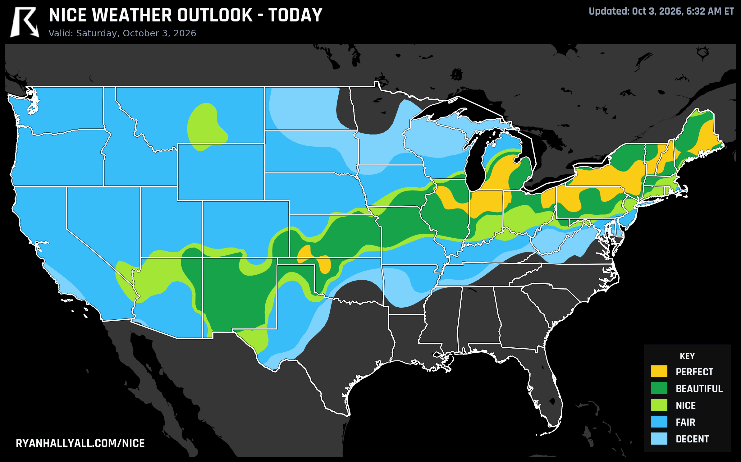
You'd expect the best seven-day stretch in the whole nice weather outlook to belong to some postcard mountain town or a beach with cold-enough-for-no-jellyfish water. Instead it belongs to Warren, Ohio, and its neighbors Champion Heights, Leavittsburg, Lordstown, Newton Falls, and South Canal, a cluster of towns in the Mahoning Valley that are sitting at the top of the national weekly rankings with a mean score of 85.9 across all seven days. Akron isn't far behind at number seven. The reason is simple: today is one of only two days this week the outlook's top category, Perfect, is even allowed to appear, and this patch of northeast Ohio is sitting almost dead center in it.
Today's Ceiling Is Perfect, and the Great Lakes Own It
A robust 1025 to 1030 millibar surface high is parked over the Great Lakes and Ohio Valley this morning, and it is producing genuinely flawless numbers. Cleveland, Peoria, Albany, Liberal, and Houlton all score in the Perfect range today, with highs near 63°F, dewpoints around 48°F, just 3 percent cloud cover, and only a 1 percent chance of rain. Winds are light at 9 mph, UV sits at a modest 5, and the air is clean with an AQI near 33. That's about as close to a weather cheat code as the scale allows, and it's the reason the Warren-area towns, which sat under this same dome, can post a 99-plus score today and ride that into the best weekly average in the country.
Further from that Great Lakes and Ohio Valley core, the day erodes gradually rather than falling off a cliff. Chicago, Buffalo, and Syracuse still land in Beautiful territory, with the Beautiful zone's one real limiter being air quality creeping just over the Perfect threshold rather than anything about temperature or wind. Push out to El Paso or Las Vegas and you're in Nice conditions, held back by UV and warmth rather than rain. It's a patio-breakfast, trailhead, yard-work kind of day almost everywhere between the Rockies and the Atlantic, just with a noticeably sharper top tier right over Ohio, Indiana, and western New York.
If you want to see how today's pattern maps out city by city, the Nice Weather outlook page has the full breakdown.
A Smaller, Western Perfect Pocket Takes Over Tomorrow
Today's broad Great Lakes Perfect zone doesn't hold its shape. By Sunday, the only patch of the country still touching the top category shrinks down to a narrow stripe of eastern Nebraska and southeastern South Dakota, Sioux City, Fremont, Norfolk, Mitchell, and Yankton, where the lightest winds of the whole outlook (under 9 mph) and a clean 33 AQI combine for a 96.1 score. Meanwhile Chicago, Cleveland, Indianapolis, Lubbock, Amarillo, and Sioux Falls all shift into Beautiful, a touch breezier and a touch warmer, but still a very good day to be outside.
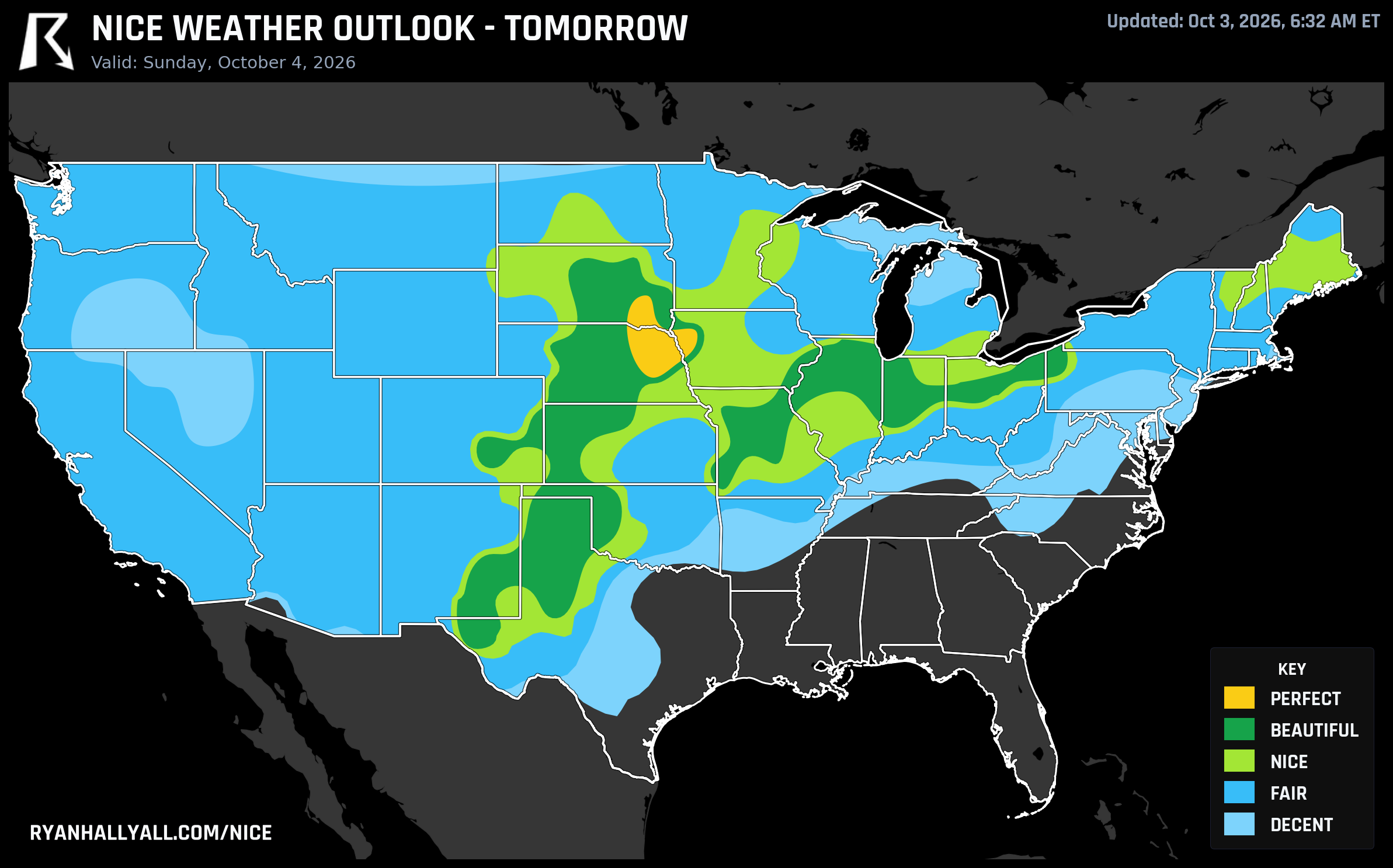
That Perfect-to-Beautiful handoff matters because the outlook's forecast-day rules only allow the Perfect category on Days 1 and 2. From Day 3 onward, Beautiful becomes the practical ceiling no matter how clean the numbers look, and Chicago, Oklahoma City, Milwaukee, Albuquerque, and Kansas City take over as the best available destinations Monday, with highs in the low 70s, dewpoints near 50°F, and essentially zero rain.
One More Hook: Albuquerque's Balloons Get a Decent Launch Window
The Albuquerque International Balloon Fiesta kicks off today, and the timing works out reasonably well. Albuquerque sits in Beautiful territory in today's Southwest rankings, with light winds and dry air, exactly what you want for mass balloon ascensions. It's not the ceiling-busting Perfect score Ohio is enjoying, but it's a comfortable, low-wind morning for anyone watching hundreds of balloons lift off.
The Nationwide Caveats Worth Knowing
This is a genuinely good-weather week for a wide swath of the country, but it's not good everywhere. The Weather Prediction Center has a continuing excessive rainfall threat along the central Gulf Coast and southern Texas coast through the weekend, lifting into the Southeast and Carolinas by Sunday, so if your nice-weather plans are anywhere near New Orleans, the Florida Panhandle, or the lower Texas coast, keep an eye on flash flood guidance rather than this outlook. On the opposite end, an anomalous October heat wave is building across central and southern California and spreading toward the Great Basin, with elevated fire weather and gusty offshore winds flagged for San Diego's foothills. That's also worth flagging against the Central Valley's eye-popping 90-day Nice streak in places like Sacramento, Stockton, and Manteca. Those streaks are real through today, but a building heat wave is exactly the kind of pattern that tends to end them.
For the rest of the country between those two trouble spots, from the Great Lakes down through the central Plains, this is as clean a stretch of fall weather as the outlook gets, crisp mornings, dry sunny afternoons, and air you can actually enjoy breathing.