Blog Article
Perfect Weather Window: Only Two Days Before the Ceiling Drops
Today and tomorrow are the only two Perfect-tier days this week. See where the best fall air is sitting and how the pattern shifts before it fades.
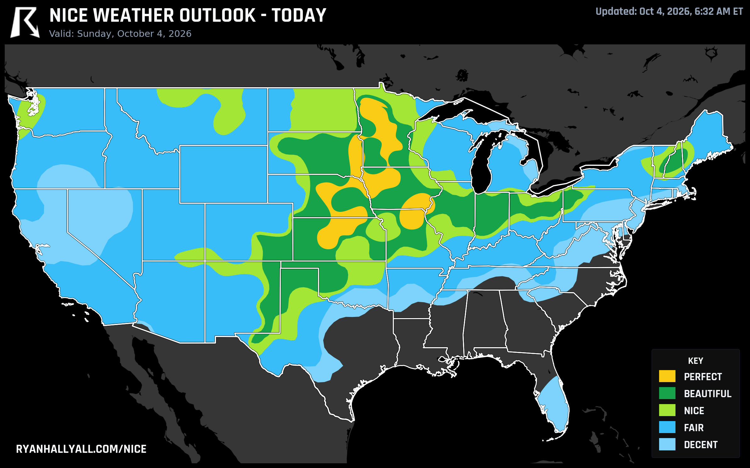
The Perfect Window Is Only Two Days Wide, and It's Sliding East
Here's something worth knowing before you plan your Sunday: this outlook only lets a day reach its top category, Perfect, on Days 1 and 2. That's not a fluke of the weather, it's a built-in forecast-day rule, and it means today and tomorrow are genuinely the best shot at top-shelf air for the next week. After that, no matter how clean the sky or how light the wind gets, the scale caps out lower. So if you've got flexibility this weekend, this is the window.
Today: Salina to Sioux Falls, a Compact Bullseye
Sunday's Perfect air sits in a tight corridor roughly 38 to 48 degrees north, 91 to 100 degrees west, running from Sioux Falls and Bloomington, Minnesota, south through Iowa City, Salina, and Kearney. A dry post-frontal high has scoured the sky down to about 1 percent cloud cover and pushed dewpoints into the high 40s. Salina, Kansas is the standout, a high near 73 degrees with a dewpoint near 54, light wind, and a score of 98.3. Sioux Falls and Iowa City are right behind it, both in the mid 90s on the composite score.
Just outside that core, a wide Beautiful band covers Indianapolis, Columbus, Omaha, Fargo, and Amarillo. The weather itself is nearly identical to the Perfect zone, it's air quality that's holding these spots back a notch, with AQI running around 39 against a 35 threshold. Indianapolis is the clearest example: its ground-level AQI reading of 61 overrides a cleaner model forecast and knocks the city down near Nice territory even though its temperature and wind numbers are textbook fall weather.
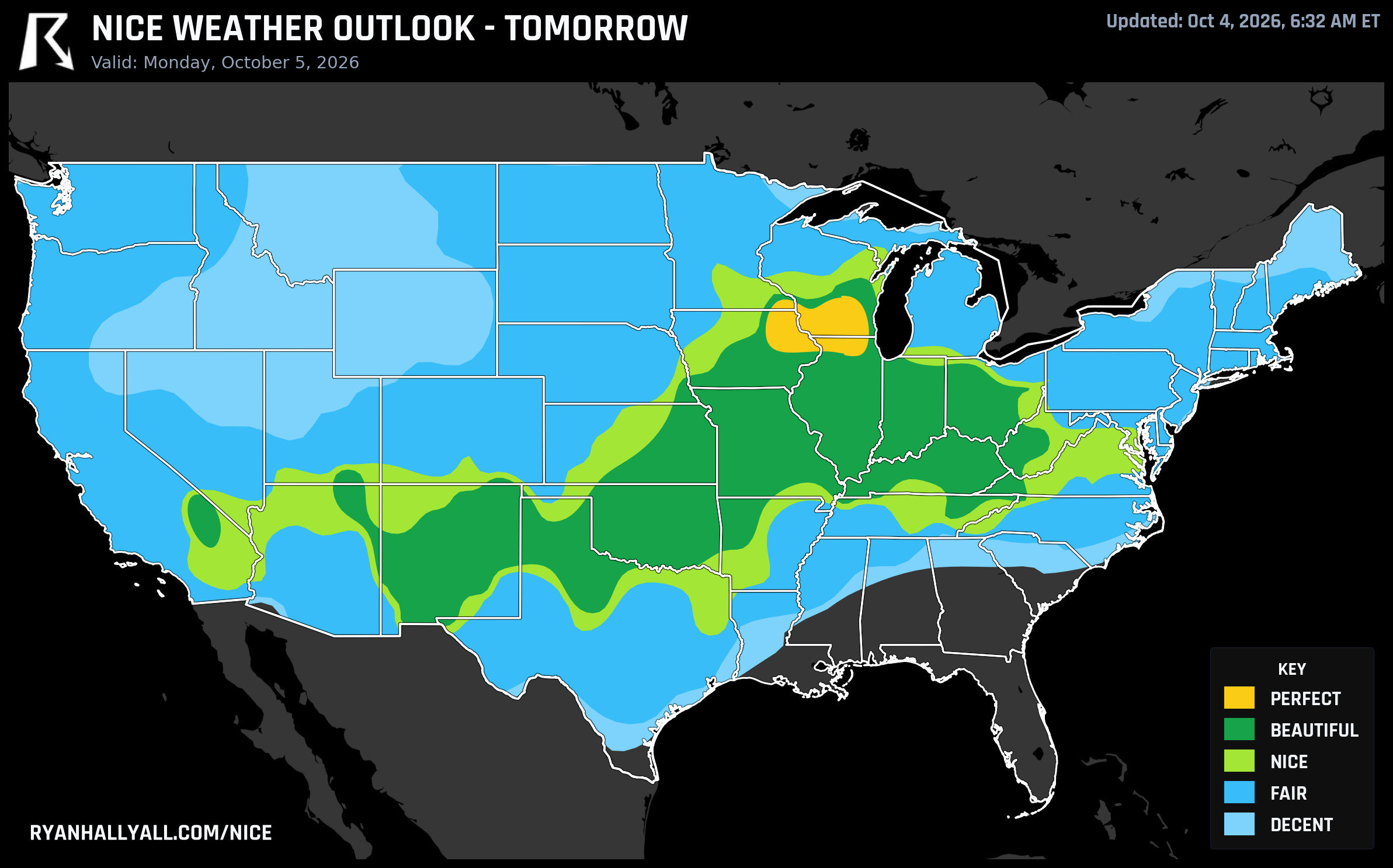
Tomorrow: The Same High Slides Into Wisconsin
Monday's version of this story moves north and east. The fresh, dry high pressure that scoured out today's Plains air settles over southern Wisconsin, northeast Iowa, and northern Illinois, and it's an even cleaner setup, Madison, Rockford, Dubuque, Cedar Rapids, and Waterloo all post scores in the high 90s to 99.2. Highs run 61 to 65 degrees, dewpoints sit in the mid 40s, and wind barely clears 7 mph. It's about as clean a composite as this outlook ever produces, a near-flawless crisp fall day for a farmers market, a long bike ride, or just sitting outside with coffee longer than you planned to.
Chicago, Oklahoma City, El Paso, and the Tennessee Valley sit a tier below at Beautiful, held back mainly by slightly warmer afternoons in the low 70s rather than anything wrong with the air itself.
Tuesday: Still Gorgeous, Just a Different Label
By Tuesday the forecast-day rule drops the ceiling to Beautiful, but the footprint actually widens. A strengthening high builds a corridor from Philadelphia and the Mid-Atlantic through Indianapolis and Dallas out to El Paso and Portland, Oregon. Highs run around 73 with dewpoints near 49, wind under 10 mph, and essentially zero rain chance. It isn't a worse day than Sunday or Monday in any way you'd feel standing outside, it just can't be labeled Perfect this far into the outlook. Los Angeles, Brooklyn, San Antonio, and Seattle land in Nice, still comfortable, though a localized air quality spike (CAMS readings as high as 92 in parts of that footprint) is the specific thing keeping them from climbing a tier.
Days 4 Through 7: The Pattern Gets Stuck, Then Breaks
After Tuesday, things settle into a holding pattern. A stalled front over the Gulf and a quasi-stationary ridge over the East keep Nice-tier pockets shifting between Philadelphia, Dallas, Seattle, Atlanta, Albuquerque, and Chicago through Thursday, but temperature becomes the binding limiter almost everywhere, with highs in the upper 70s and rising cloud cover eroding scores across the broader Midwest and South. Gulf Coast humidity creeps in too. Houston and Jacksonville both dip into the 50s on the composite by midweek as that stalled boundary keeps dewpoints and rain chances elevated, consistent with the heavier rainfall risk WPC has flagged for the Gulf Coast and Southeast through this period.
By Day 7, Saturday, the pattern finally breaks, but not in a good way for comfort. Cloud cover jumps toward 60 to 64 percent across a wide swath, and wind gusts push into the low 20s as an eastbound trough approaches. The sky sub-score collapses to around 40, the sharpest single-day drop of the week. Confidence is lower out here, as WPC itself has flagged a notable change in western U.S. guidance, so treat Days 6 and 7 as a general trend rather than a locked forecast.
A Few Things Worth Flagging
Out west, this has nothing to do with the heat wave WPC is tracking across California and the Great Basin, a long-duration, unseasonably warm stretch building through the period. It's a separate story from the Plains and Midwest pattern driving this week's Perfect and Beautiful air. Interestingly, some of the longest live weather streaks in the country right now are sitting in that same hot, dry territory, places like Weldon and the Indian Wells Valley in California and the Twin Falls area of Idaho have run 30-plus days at Nice or better, a reminder that dry air and calm wind can carry a score a long way even when afternoons run warm.
If you're headed to Austin City Limits this weekend, know that the nicest air in the country isn't over Texas. The closest comparison point, San Antonio, is running in the Nice tier with afternoon heat index readings pushing past 100 in spots, so hydration and shade breaks matter more there than umbrella duty.
And if you want to track how any of this shifts day to day, the full map and city-by-city breakdown lives on the Nice Weather outlook page, updated as the pattern evolves.
Bottom line: if you want the best air this outlook can produce, Sunday and Monday are it. Everything after is still good, in some cases genuinely lovely, but the ceiling comes down a notch and the pattern gets a little stickier as the week goes on.