Blog Article
Best Weather Days This Week: Beautiful Tier Today and Tomorrow
A Beautiful-tier weather band spans the Mid-Atlantic to the southern Plains today and shifts to the Southeast tomorrow, the two best days before the pattern flips west by the weekend.
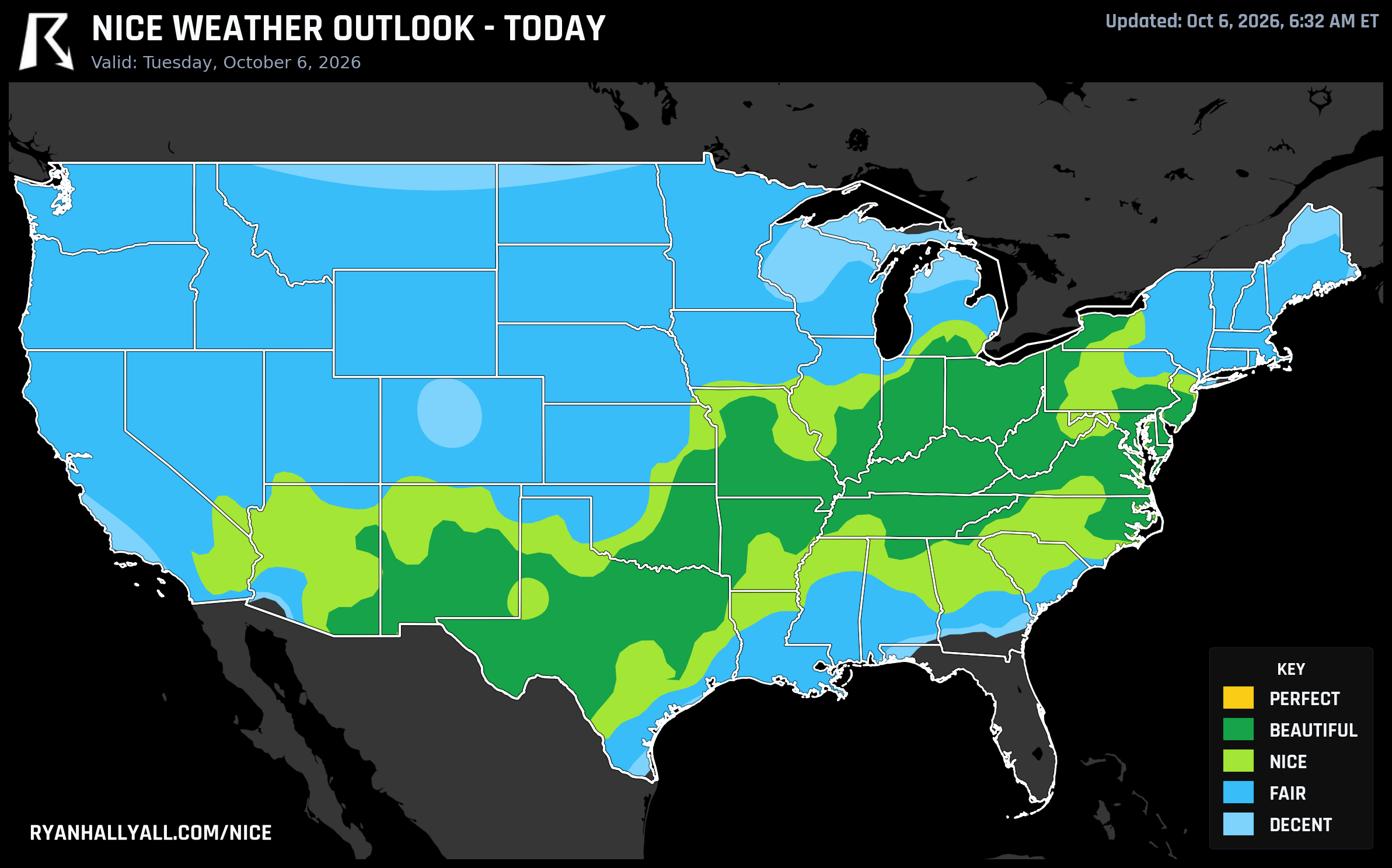
Grab It While It's Beautiful: Today and Tomorrow Are the Best This Week Gets Before the Map Flips West
If you've got a patio breakfast, a long walk, or a school pickup you've been dreading because of heat or bugs, today and tomorrow are your window. A big chunk of the country from the Mid-Atlantic down through the Ohio Valley and into the southern Plains is sitting in Beautiful territory, and it's not sticking around all week.
Today: A Beautiful Band From Philly to El Paso
High pressure is doing exactly what high pressure does best. Philadelphia and Washington, DC are sitting at a score of 92, Nashville and Albuquerque are right there too, and the whole Ohio Valley through the southern Plains corridor is clear, dry, and comfortable. Highs in the Beautiful zone average around 75 degrees with dewpoints near 50, winds barely above 8 mph, and skies basically cloudless at 2 percent cover.
The only thing keeping this from reaching Perfect is air quality. Dallas and El Paso are both running an effective AQI near 60, with some pixels spiking into the 100s, and that's enough to hold the whole zone back even though temperature, wind, sky, and precipitation all individually clear the Perfect bar. It's a reminder that these categories aren't vibes, they're gated by the weakest link.
Worth a shoutout while we're here: a long stretch of Northern California towns, Green Valley, Roseville, Vallejo, Fairfield, Napa, and a dozen others in that Sacramento-Bay Area corridor, are riding 90-day live streaks of Nice-or-better weather. That's three months of consistently pleasant air while the rest of the country has been dealing with flash floods and frost advisories. Quietly one of the best runs on the board.
Tomorrow: The Beautiful Zone Shifts Southeast
Wednesday keeps the high-pressure setup but relocates the best air. Dallas and El Paso hold onto Beautiful, and the zone expands hard into the Southeast and Mid-Atlantic: Virginia Beach, Raleigh, Greensboro, Fayetteville, Augusta, Columbia, Athens, and Wilmington are all scoring 92. Dewpoints run in the mid-50s, rain chances sit near 1 percent, and winds stay light. This is as close as the week gets to Perfect, missing by just 2 points on temperature alone, since afternoon highs near 80 are comfortable but a touch warm for the top tier.
If you've got outdoor plans anywhere from north Texas through the Carolinas and Georgia, Wednesday is the pick.
Thursday Onward: The Ceiling Drops
Starting Thursday, the forecast-day rule caps the whole country at Nice, regardless of how good the underlying numbers get. The best corridor shifts to an interior belt running from Albuquerque through Kansas City, Chicago, and Pittsburgh, with Austin in the mix too, but it's held back less by rain or clouds and more by temperature averaging across a wide latitude band, cool mornings up north blending with warm afternoons down south in the same zone score.
Thursday and Friday (Day 4 and Day 5) keep a warm, dry interior swath going from Philadelphia through Dallas and the Desert Southwest, but gusty winds become the story as a dry frontal boundary moves through, and by Friday a developing Gulf system (the one meteorologists have been watching as Invest 92AL) starts pushing fetch inland, with gusts above 35 mph covering nearly a quarter of the broader comfort zone. Houston sits at the bottom of the city list both days as Gulf moisture and cloud build ahead of that system.
The Weekend Flip: Best Weather Moves to the Coast
Here's the real shift to watch. A trough digging out of British Columbia into the Pacific Northwest and Northern Rockies completely rearranges the map by Saturday and Sunday. The nicest weather in the country relocates entirely to the West Coast, San Jose, San Francisco, Seattle, Fresno, and a long list of Oregon and Washington cities all land in the 80s for score, while the central and eastern US degrades on expanding cloud cover and rising rain chances.
That timing matters if you're tracking the Chicago Marathon on Sunday, October 11. Chicago sits in the Nice tier that day, but with cloud cover averaging 40 percent and wind near 14 mph gusting higher, expect a breezier, grayer race morning than the sun-soaked stretch we're in right now. Not bad weather, just a notable step down from today's clarity.
The Caveats Worth Knowing
While the interior US enjoys this stretch, Florida and the northern Gulf Coast stay locked in a soggy pattern, WPC has marginal excessive rainfall risk posted there through Thursday as a stalled front keeps wringing out tropical moisture. And in the Beautiful zones out west, AQI is the one thing to watch, not rain or wind. Dallas and El Paso both sit right at the edge of air quality thresholds today, so if you're sensitive to particulates, it's worth a quick check before a long outdoor session.
For the day-by-day breakdown and city-level scores, the Nice Weather outlook page has the full picture, including where that West Coast flip lands by the weekend.
Bottom line: if your outdoor plans are flexible, move them to today or tomorrow. The rest of the week is still fine in most places, but this two-day stretch from the Mid-Atlantic to the southern Plains and Southeast is the best air the whole forecast period has to offer.