Blog Article
West Coast Wine Country Has the Best Weather in the Country
From Seattle's clear skies to California wine country's 90-day Nice streak, the West Coast dominates this week's Nice Weather Outlook while a storm hits the Plains and Midwest.
From Seattle to Sonoma, the West Coast Is Having the Best Week in the Country
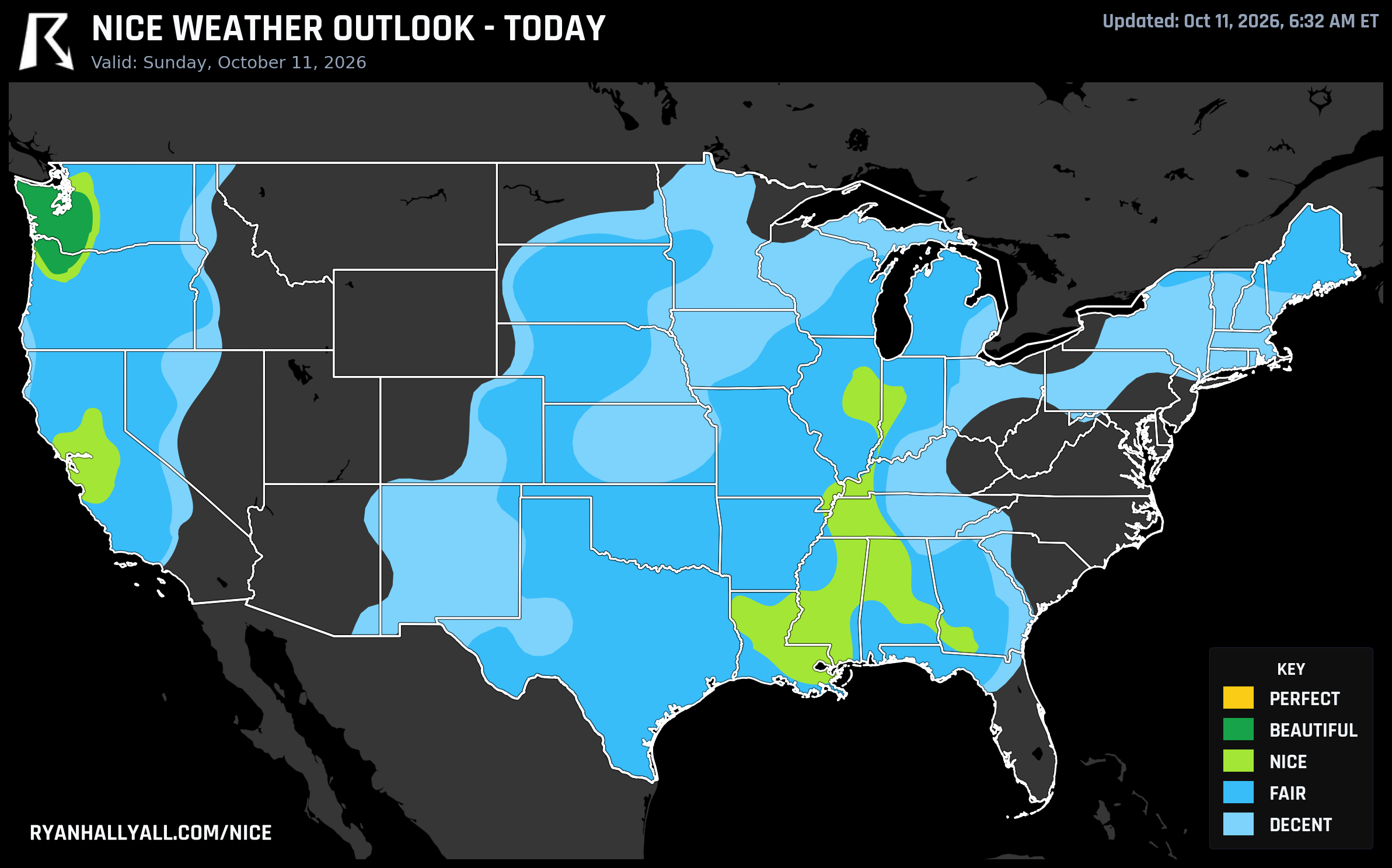
While the headlines keep chasing Hurricane Simon and Tropical Storm Rachel's leftovers, the quieter story this week is the whole West Coast settling into a run of genuinely good outdoor weather. Today, Sunday October 11, is arguably the best single day of that run, and it stretches from Puget Sound down through California's wine country and into the Sacramento Delta.
Today: Seattle's cool and clear, the Central Valley is warm and clean
Western Washington and northwest Oregon are sitting at the top of the national board today, rated Beautiful, the best showing anywhere in the country. Seattle tops out near 57.8 degrees, Portland near 62.7, Tumwater around 56.3, all under mostly clear skies (sky cover scoring 98.6 out of 100, essentially 0 to 17 percent cloud) and light wind. Dewpoints in the low 40s keep the air crisp rather than damp. The catch is right there in the numbers: it's a cool-for-comfort kind of beautiful, not a warm one, and clear skies plus calm air mean frost is likely in sheltered valleys overnight. If you've got tender plants in the Willamette Valley or south Puget Sound, bring them in tonight.
Down in California, it's harvest season in more ways than one. Sacramento, Fairfield, Vacaville, Suisun, Dixon, Rio Vista, and Pittsburg are all posting a 92 today, officially Nice, with San Jose and San Francisco close behind in the 81s. That's the Sacramento Delta and Central Valley running about as clean as it gets this time of year. One caveat worth flagging if you're out there: the Storm Prediction Center's fire weather desk has an elevated fire risk posted for the northern Sacramento Valley today, where gusty post-frontal north winds of 15 to 25 mph, with gusts to 30 or 40, are combining with downslope drying. The air quality readings are good everywhere in this corridor right now, so this is strictly a wind-and-dryness concern, not a smoke one, but it's worth knowing if you're planning anything with an open flame.
The 90-day streak behind all of this
None of this is a fluke. Oakland, Berkeley, Concord, Vallejo, Richmond, Hayward, Antioch, San Leandro, Livermore, Alameda, Walnut Creek, Pleasanton, Dublin, Danville, Martinez, and a dozen more East Bay cities are riding a 90-day streak of Nice-or-better weather, a streak that stretches back to mid-July and hasn't broken yet. That's basically the entire second half of summer and all of the harvest season without a bad-weather day in the mix.
That streak lines up with something clear in this week's full leaderboard, too. The strongest week-over-week scores in the country aren't concentrated in big cities, they're scattered across actual wine country: Boonville out in Mendocino's Anderson Valley, Windsor, Sebastopol, Guerneville, Occidental, Graton, Monte Rio, and Bodega Bay in Sonoma's Russian River country, Roseburg North and Eugene up in Oregon's Willamette Valley, plus Cambria on the Central Coast and the Delta towns already mentioned above. Different pockets of that list peak on different days this week. The Delta and Central Valley towns are having their best day today. Boonville's best day is tomorrow, Monday, when it should hit a score near 91.7. The Sonoma coastal towns, interestingly, catch their best day later in the week, on Friday, as the pattern shifts around them. If you're planning a tasting-room weekend or a Russian River float anywhere between now and next weekend, you've got options almost every day.
The middle of the country has a rougher week ahead
The national Nice Weather discussion is blunt about what's driving this: a ridge over the High Plains and Intermountain West is keeping that zone dry and mild through midweek, while a progressive trough drags increasing wind and shower coverage across the Plains, Midwest, and Northeast, bottoming out Thursday into Friday before a cold frontal passage flips the pattern again. Gulf Coast and Southeast humidity is the other persistent drag all week, with Houston, Jacksonville, and Montgomery repeatedly getting capped by dewpoints in the 60s and 70s and heat indices pushing into the 90s. The WPC's extended outlook actually calls for record heat across the Southern Plains, Mid-South, and Southeast into Thursday before things moderate, which is a strange thing to read in mid-October but tracks with what the Nice Weather data is showing for that corridor all week.
Tuesday (Day 3) is the one day the Nice tier actually migrates east for a bit, with Charlotte, Washington DC, Raleigh, Virginia Beach, and Fayetteville joining San Jose, San Francisco, Fresno, Sacramento, and Stockton at the top of the list, a brief window of comfortable air working in ahead of the next system. By Wednesday and Thursday the ridge retreats back to the West, and Western cities carry almost the entire board on their own, with Phoenix, El Paso, Tucson, Las Vegas, Boise, and a run of Southern California cities all scoring Nice, joined by an unexpected guest: Boston, which sneaks into the top 10 on Thursday with a 72.
Thursday into Friday (Day 6) is described as the low point of the stretch for the storm-affected corridor, with severe-gust coverage jumping sharply across parts of the Midwest. The West Coast mostly shrugs this off, with Los Angeles, San Diego, Portland, Las Vegas, Atlanta, Riverside, Montgomery, and Eugene holding Nice-tier scores while the center of the map struggles.
Saturday brings the best scores of the stretch
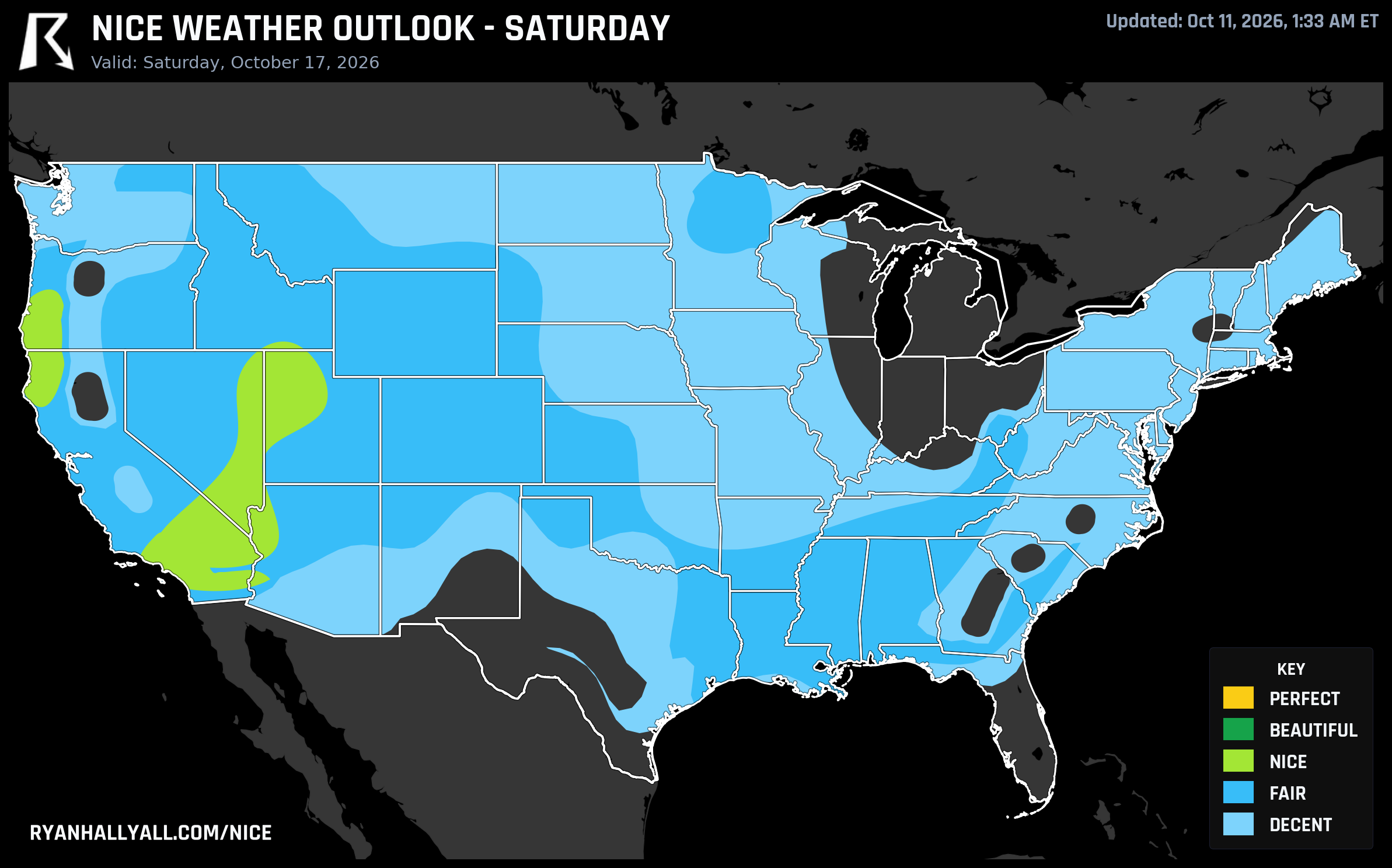
By Saturday (Day 7), a post-frontal ridge rebuilds over the Rockies and Intermountain West, and the Nice Weather Outlook discussion calls this the best scoring setup of the whole seven-day period. Los Angeles, Las Vegas, Riverside, Oxnard, Salt Lake City, Eugene, and Escondido all land at 82, officially Nice, under dry air and light wind. It's a few days out, so hold that with the usual grain of salt that comes with extended forecasts, but the signal has been consistent across the whole dataset: this is a ridge-driven pattern, and ridges over the Intermountain West this time of year tend to deliver.
One more thing worth watching if your plans run through Nevada, Utah, or Arizona in the next day or two: WPC has a Moderate risk of excessive rainfall posted today across the Great Basin and Southwest as Post-Tropical Cyclone Rachel's remnant moisture streams north, with a Slight risk continuing into Monday for northwest Arizona into Utah along the Wasatch. That's the same general area that climbs into the Nice tier by the weekend, so the rough patch should clear out before the good stretch arrives there.
And if you're one of the thousands lining up for the Chicago Marathon this morning, you're not in today's featured zone, but you're not in bad shape either, with breezy conditions and temperatures in the low 70s expected through the race.
For the day-by-day breakdown and maps as the week updates, check the Nice Weather outlook page.