Blog Article
Gold Country's 90-Day Nice Streak and Wednesday's Best Day
A 90-day Fair-or-better streak holds in California's Sierra foothills while Wednesday brings the week's best weather to the Northern Rockies and High Plains.
Gold Country's 90-Day Streak Keeps Rolling While Wednesday Brings the Week's Best Single Day
While the news cycle is busy with Hurricane Simon parked off Mexico and a Plains severe weather setup building for Tuesday, there's a quieter story worth your attention: a handful of towns in the California foothills haven't had a bad outdoor day since midsummer, and the rest of the country is about to get a genuinely gorgeous Wednesday courtesy of the Northern Rockies.
The longest active streak in the country
Newcastle, Cameron Park, Diamond Springs, Shingle Springs, Auburn, Placerville, Georgetown, Foresthill, Cool, and a string of other small towns in California's Sierra foothills east of Sacramento are riding a 90-day streak without a single day dropping below Fair. That run started back in mid-July and it's still live today. A few of these towns, like Auburn and Cameron Park, even touched Beautiful as recently as late August.
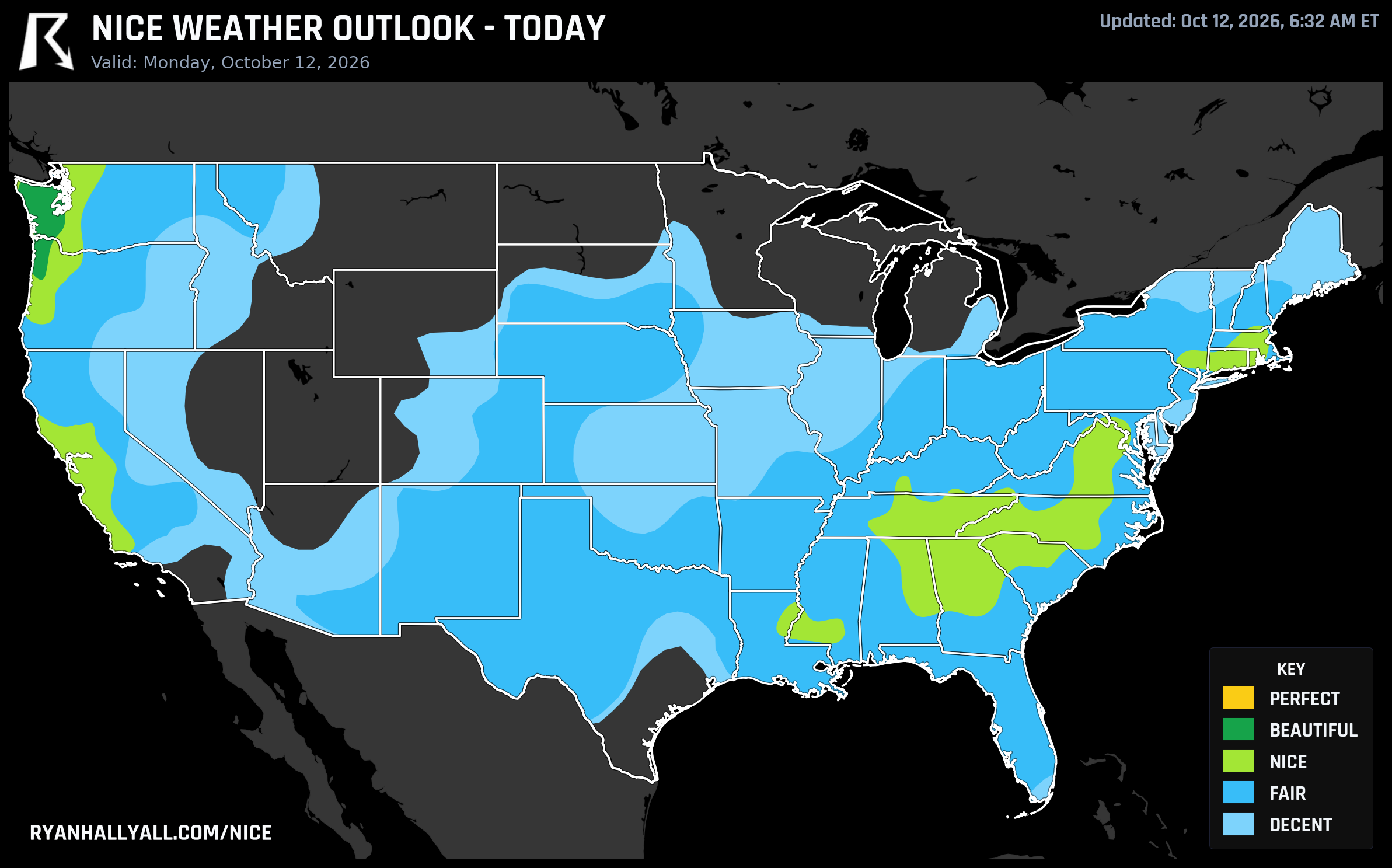
Today keeps that streak alive in style. The broader Sacramento Valley and foothills corridor, including Elk Grove, Lodi, and Galt, is sitting at a 92 score and Nice category today, driven by light wind, clean air, and comfortable afternoon highs. It's the kind of stretch where you stop checking the forecast for your weekend plans because you already know the answer.
Today's real headline: a one-day Southeast spike
Here's a detail buried in the data that deserves more attention than it's getting: Knoxville, Greenville, Maryville, Greer, Taylors, and a cluster of other Ohio Valley and Upstate South Carolina cities are hitting 92 today, their single best day of the entire seven-day outlook. If you're in the Smokies or the Upstate and you've got anything outdoors on the calendar this week, patio breakfast, trailhead mornings, a school pickup where you don't need a jacket, today is the day to use it. Clear skies and light wind are carrying these spots, though it's worth noting the Deep South is running warm underneath all that sunshine, with highs pushing into the upper 80s and low 90s from Alabama into the Carolinas. Dry air keeps it more tolerable than the raw numbers suggest, but midday exertion will still feel like summer, not October.
Meanwhile the Pacific Northwest coast, Olympia, Port Angeles, Hoquiam, is technically today's highest-scoring zone nationally, sitting at Beautiful with highs only in the low 50s. It's gorgeous, but it's a different kind of gorgeous: bring a jacket, not sunscreen.
Wednesday is the day to circle
If you want the single best outdoor day of the week, look past today and toward Wednesday, October 14. The Day 3 outlook pegs a BEAUTIFUL-tier zone across the central High Plains and northern Intermountain West, Tri-Cities, Yakima, and Walla Walla in Washington, Bend and Medford in Oregon, Fargo in North Dakota, and Billings in Montana. All of them score 92, and because Beautiful is the highest category the forecast model allows that far out, this is as good as it gets anywhere in the country this week.
The numbers back it up: highs near 65 degrees, lows near 44, dewpoints in the low 40s for that crisp fall-afternoon feel, winds under 10 mph, and rain chances essentially zero. Mornings will be chilly enough for a light layer, but by afternoon it's trail, yardwork, and tailgate weather across a huge stretch of the Intermountain West.
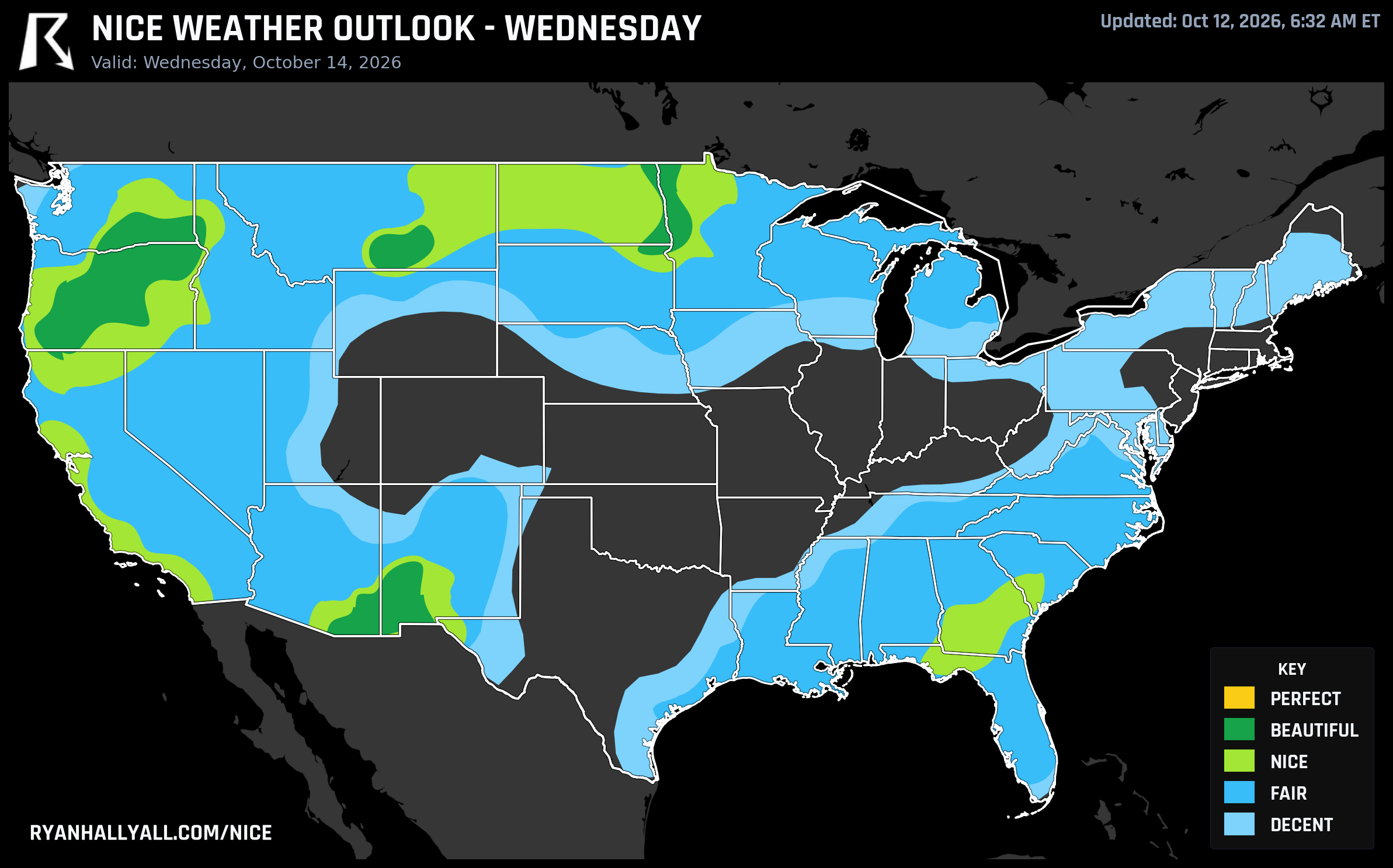
One caveat worth flagging: a handful of pockets inside that same region carry locally elevated air quality readings even though the zone average looks clean, so if you're sensitive to smoke or particulates, it's worth a quick local check before a long trail day.
Where the good weather goes next
By the back half of the week, the pattern shifts. A building ridge over the South Central and Southeast states pushes into record warmth for the Mid-South and Southeast through Thursday, while the nice-weather action migrates toward the desert Southwest and Texas. By Friday and Saturday, Los Angeles, San Diego, Las Vegas, Houston, Dallas, San Antonio, Austin, and Memphis are all projected to reach Nice-tier conditions, 82 out of 100, as drier air and lighter wind take over.
That's good timing if you've got travel plans to any of those cities for the weekend. It's less good news for the central Plains and Midwest, which stay stuck in Fair-to-Decent territory through the period behind a slow-moving storm system. The Storm Prediction Center has a Slight Risk of severe storms Tuesday across Kansas City, Wichita, and Topeka, and WPC is tracking a heavy rainfall threat that follows roughly the same corridor into the Ozarks by Wednesday and Thursday. If your week includes Kansas City or Wichita, keep an eye on that rather than planning around sunshine.
There's also a nice regional tie-in for anyone headed to the North Carolina State Fair in Raleigh starting Thursday. We don't have Raleigh-specific scores in hand, but the broader Southeast corridor, including Charlotte and Greensboro, has stayed mild and mostly dry through this whole stretch, which is a reasonable sign for fairgoers even without a direct number to point to.
For the daily rundown of where the scores stand and which cities are riding streaks like Gold Country's, the Nice Weather outlook page tracks it all, updated every morning.