Blog Article
Virginia & Carolinas Peak Nice Weather Day Is Today, Oct 13
Norfolk, Virginia Beach, and a swath of North Carolina towns hit their best nice-weather score of the week today, before breezier air arrives by Thursday's NC State Fair.
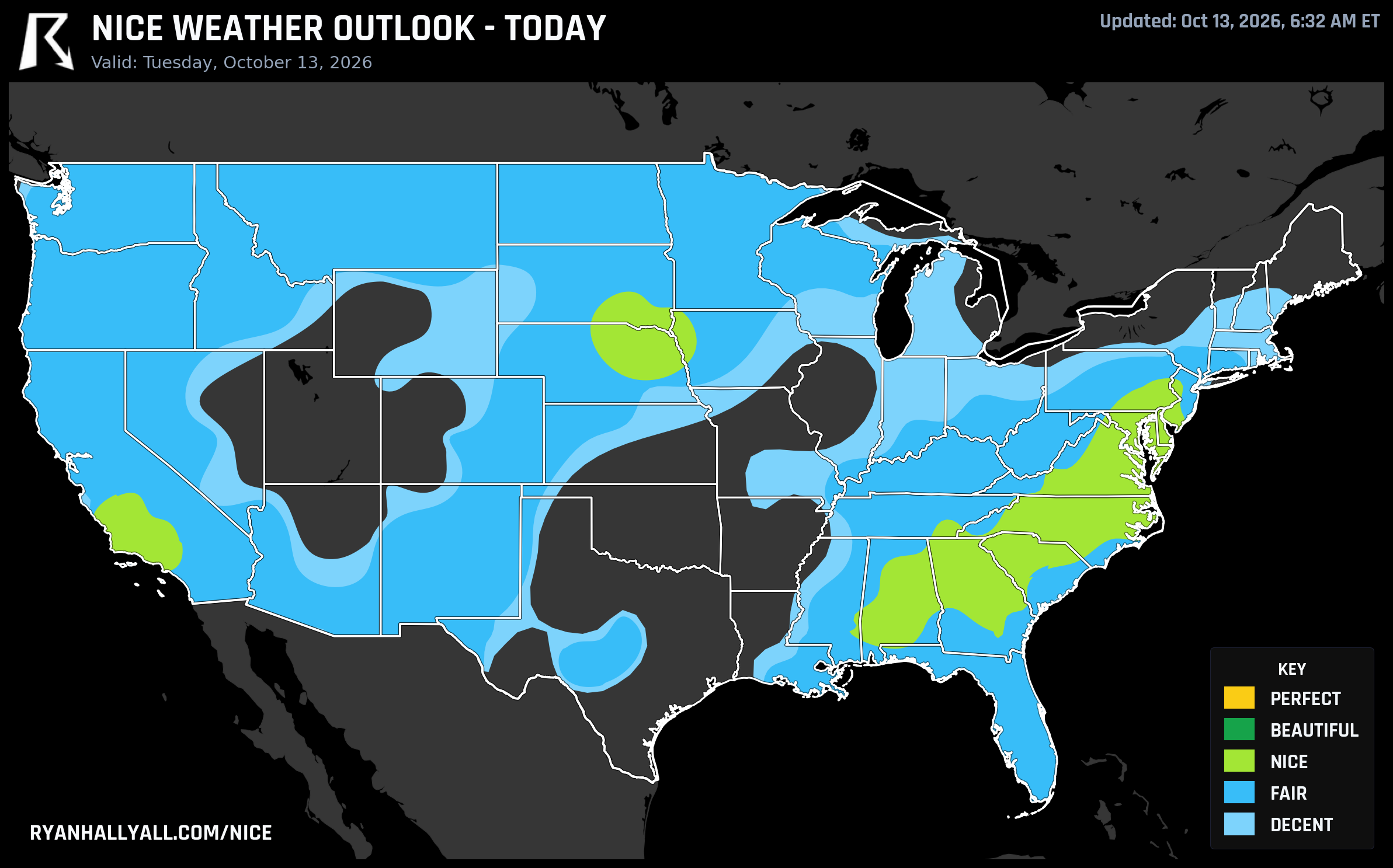
Coastal Virginia and the Carolinas Hit Their Best Day of the Week Today
If you live anywhere between Williamsburg and Gaffney, South Carolina, today is the day to cancel your indoor plans. A broad dome of high pressure has settled over the Southeast and Mid-Atlantic, and when you run the numbers against the rest of this week's forecast, a surprising number of cities are hitting their single best nice-weather score of the next seven days right now, on a Tuesday.
Norfolk, Chesapeake, Newport News, Portsmouth, Suffolk, and Williamsburg, Virginia, are all sitting at 92 out of 100 today. So are Rocky Mount, Shelby, Morganton, and Cherryville in North Carolina, plus Gaffney just across the South Carolina line. None of those towns will see a number that high again this week. A couple of their neighbors, Hampton and East Hampton, also hit 92 today but land one notch lower in the category scale, a reminder that these scores are gated on things like dewpoint and sky cover, not just a single composite number. Even an identical score can sort into a different tier depending on which sub-scores clear the bar.
Why today specifically
According to today's outlook discussion, the broad comfort zone running from the Carolinas and Mid-Atlantic back through the Gulf Coast, with an unlikely assist from the cooler northern Plains around Sioux Falls, is riding close to flawless sub-scores: precipitation chances near 1 percent, cloud cover averaging just 12 percent, and wind holding to a light 8 mph. Heat stress and sky cover sub-scores both clear 96 out of 100. Temperature and dewpoint sub-scores land in the mid-80s. Every single category that feeds the composite score is strong.
The one thing holding this zone back from an even higher tier is air quality. The zone's effective AQI sits at 54, just above the 50 threshold needed to climb a notch, even though that number is still in generally acceptable territory for most people. It is not haze you'll necessarily notice walking out your door, but it is the technical ceiling on an otherwise about-as-good-as-it-gets day. Highs in this swath run from the mid-80s to around 91°F in spots like Birmingham, with Mid-Atlantic cities like Charlotte, Philadelphia, and Richmond running more in the upper 70s to mid-80s. Morning temperatures are genuinely pleasant, commonly in the 50s and 60s, with patchy valley fog burning off quickly.
Meanwhile the central and northern Plains are stuck in the 50s and 60s under more clouds, and a slight risk of severe storms is spinning up today from Kansas City to Wichita as a system digs into the Four Corners. That's the trade-off behind this week's warmth: the same broad ridge keeping the East comfortable is also funneling unstable air north out of the Gulf, setting up several days of heavy rain and a few strong storms across the Heartland. If your travel plans run through Kansas or Missouri today, keep an eye on the sky even as the Southeast enjoys a near-perfect afternoon.
What happens by the time the fair opens
The North Carolina State Fair opens in Raleigh on Thursday, and the timing is a little bittersweet for fairgoers. Raleigh is riding a genuinely strong stretch of weather right now, but WPC's extended discussion flags an amplifying upper trough moving through later this week, with a cold front sweeping severe-capable storms and gusty winds across the Great Lakes, Ozarks, and Northeast by Friday and Saturday. Closer to the fairgrounds, Thursday's own outlook shows wind becoming the dominant limiting factor across the Plains, Midwest, and East Coast fringes, with gusts in some FAIR-tier zones running as high as 22 mph and roughly a fifth of that zone's area seeing gusts strong enough to trigger a severe-wind flag. Translation: Thursday should still be dry and reasonably mild for the fair's opening day, but it won't have the same glassy, still-air quality that coastal Virginia and the Carolinas are getting today. Pack a light jacket for the midway after dark.
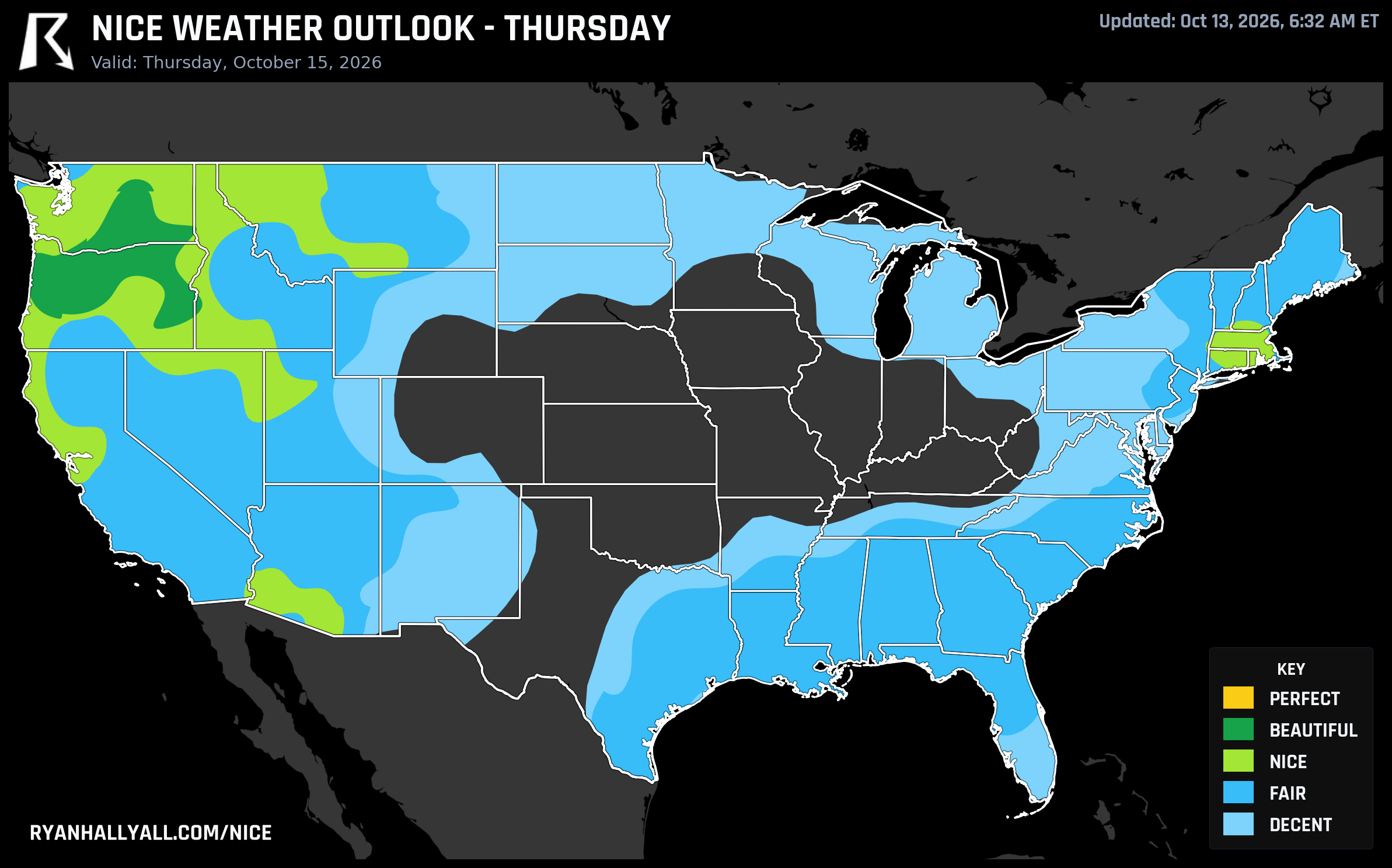
For a sense of where that same crisp, breeze-free air is heading next, Thursday's real standout shifts out west. Portland, Eugene, Bend, Tri-Cities, and Wenatchee settle under a strengthening Pacific high with dry air and highs in the upper 60s to low 70s, a nice follow-up act once the Southeast's current stretch eases off. The Southwest's turn comes a touch earlier, with Tucson and Sierra Vista, Arizona, climbing into the top tier Wednesday as dry desert air and light wind build in behind the retreating trough.
The honest caveat
None of this is severe or dangerous weather for the Southeast today. The caveat is modest: that AQI reading near 54, UV indices running a moderate 5 to 6, and the simple fact that this particular stretch of excellent air doesn't hang around all week for everybody. If you're near Virginia Beach, Norfolk, Richmond, or the central Carolinas, today is genuinely the pick of the litter. For the full rundown of which cities are scoring where right now, the Nice Weather outlook page has the live map and rankings.
Enjoy the patio breakfast, the ballpark afternoon, or the trail run today. This particular window closes by Thursday, even if the fair carries on just fine without it.