Blog Article
Santa Barbara Wine Country Tops This Week's Nice Weather Rankings
Santa Barbara, Goleta, and the Santa Ynez Valley lead the week's nice weather scores, tied with Washington's Tri-Cities, while a Thursday fire weather risk looms for the same coast.
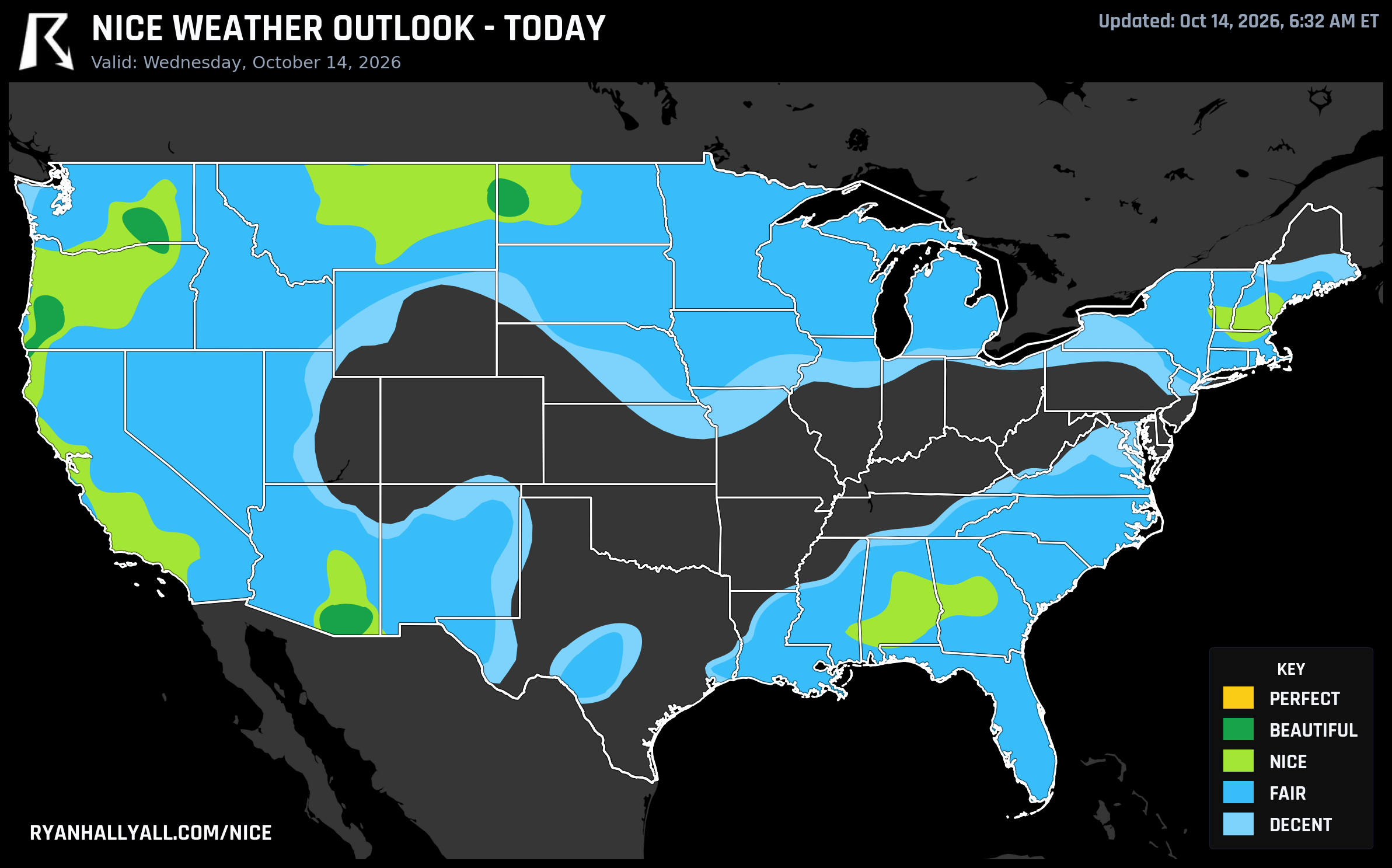
Santa Barbara Wine Country Is Quietly Having the Best Weather Week in the Country
If you pulled every nice weather score from the last seven days and let the data pick a winner without any editorial thumb on the scale, it wouldn't pick a beach, a ski town, or a big metro. It would pick a cluster of small towns along Highway 154 and 101 in Santa Barbara County, where tasting rooms are finishing up harvest and the patios at Los Olivos and Solvang have had almost nothing to complain about all week.
Isla Vista tops the entire weekly leaderboard with a mean score of 82 across all seven days. Right behind it: Santa Barbara, Goleta, and Mission Canyon, all averaging 80.6 with six Nice-or-better days out of seven. Keep scrolling the list and it's basically a drive through Santa Barbara County wine country, Santa Ynez, Solvang, Buellton, Los Olivos, Los Alamos, all logging their best single day of the week today with a score of 92, which lands them in the Beautiful tier.
Today's data explains why. The Day 1 outlook puts the best conditions in the country over the central Rockies and Intermountain West, a zone that stretches far enough to reach the Southern California coast. Highs run near 71°F, lows near 46°F, dewpoints around 43°F, cloud cover just 19%, and rain chances basically zero at 2%. According to the discussion behind the maps, this zone is sitting at 85.7 out of 100, and the only thing keeping it out of the top Perfect tier is a pair of narrow misses: wind scores 90.7, just under the 92 threshold, and the air quality reading of 43 clears the easier gates but not Perfect's stricter ceiling of 35. In plain terms, it's about as good as October gets without being flawless on paper.
There's a Pacific Northwest twin to this story. Tri-Cities and Walla Walla, Washington, both post a 92 today, right there with the California wine country crowd, and Tri-Cities does it again tomorrow at 91.8 while Yakima joins at 82. Two wine regions, one on the Columbia Valley side and one on the Central Coast, both catching their best stretch of the season at the same time, for the same reason: dry high pressure sitting overhead with light wind and clean air.
One caveat worth flagging for anyone in that Santa Barbara to Los Angeles corridor. The same ridge that's producing this gorgeous stretch starts to reverse itself by Thursday. SPC's fire weather outlook calls for an increasing offshore pressure gradient across Southern California, with east-northeast winds of 15 to 25 mph, gusts 30 to 50 mph in the valleys and possibly 60 mph in the mountains, and relative humidity as low as 10% in western L.A. and Ventura counties. The patio weather doesn't go away, but the fire risk ticks up right alongside it, so if you're in those wind-prone canyons, it's worth keeping an eye on local fire weather headlines even while the comfort numbers stay pretty.
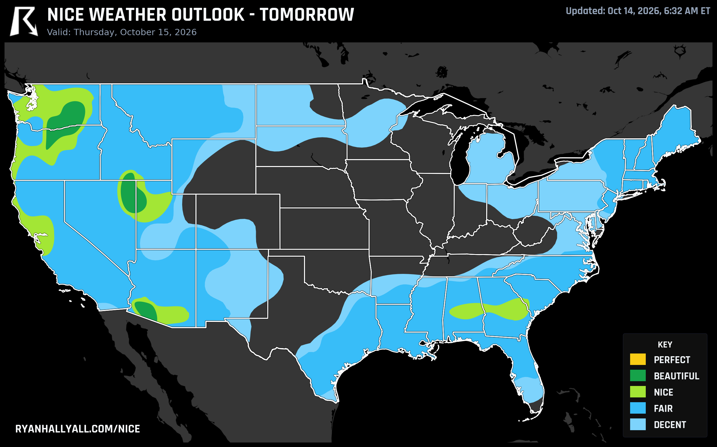
A quieter but genuinely remarkable footnote sits just inland. Towns like Tracy, El Dorado Hills, Folsom, Cameron Park, Rancho Cordova, and Auburn are riding 90-day live streaks of Nice-or-better weather, the longest active streaks in the entire tracked history. Their last Perfect day was back on August 29, and they haven't dropped below Nice since. That's the Sacramento Valley and Sierra foothills quietly stacking up one of the longest good-weather runs of the year while all the attention goes to the coast.
Looking past today and tomorrow, the national picture gets more complicated. The forecast-day structure caps Days 3 through 7 at a Nice ceiling no matter how good any single zone's raw numbers look, and a stronger storm system is the reason why. WPC's extended discussion flags a deep trough moving through the East on Saturday, with a cold front pushing frost and freeze concerns from the Plains into the Midwest and East through early next week, plus a marginal severe threat sliding into the Mid-Atlantic by Friday. By Day 5, the Plains and Midwest core actually climbs back toward the day's best score, 80.5, as winds relax behind the front, pulling Dallas, Indianapolis, Philadelphia, and Manhattan up to 82 apiece. It's a decent weekend setup for the middle of the country, just a cooler and breezier one than what Santa Barbara and the Tri-Cities are enjoying right now.
And while wine country soaks up its best week of the fall, it's worth remembering the flip side sitting just a few hundred miles east. WPC has a moderate risk of excessive rainfall today across Oklahoma and the Texas Red River Valley, with 2 to 4 inches possible and a repeat of yesterday's severe thunderstorm outbreak still fresh, 88 mph gusts near Goodlett, Texas, and hail over two inches in Motley County. Nice weather and nasty weather are often just a state line apart this time of year.
If you want to check how your own town stacks up through the rest of the week, the full breakdown lives on the Nice Weather outlook page, updated daily as these patterns shift.