Blog Article
Nice Weather Outlook: West Ridge Today, Ark-La-Tex Peaks Saturday
A building Western ridge brings near-perfect weather to the Pacific Northwest and Southwest today, while the Ark-La-Tex corridor peaks this weekend as the week's best stretch.
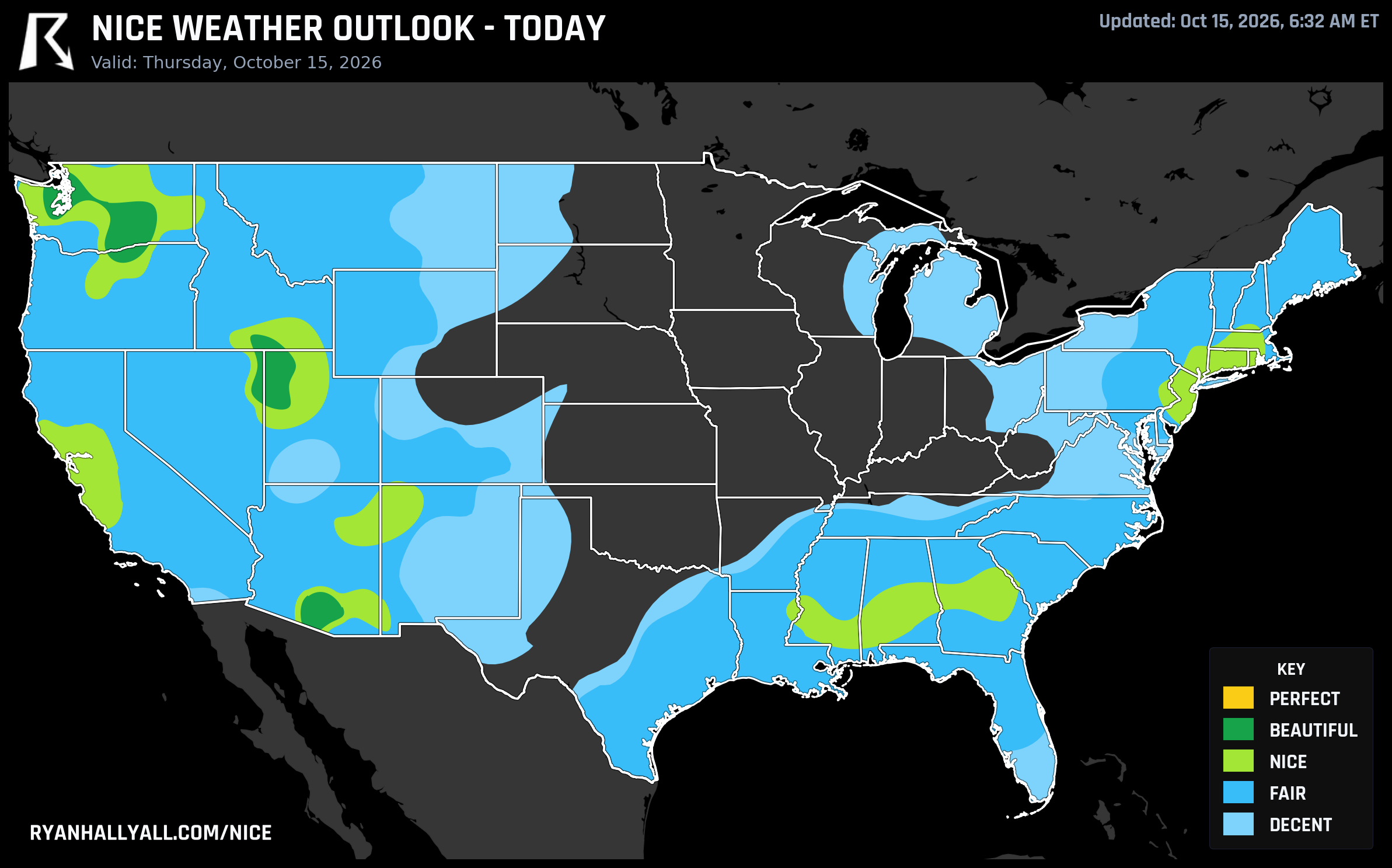
The Ridge Protects the West Today, Then the Front Pays Off in the Ark-La-Tex
Yesterday was rough in a lot of places. Oklahoma got two to eleven inches of rain out of training thunderstorms, there were high-water rescues near Greenfield, and a tornado touched down near Fort Stockton, Texas. That same system is still working through the Ohio Valley and Mid-Atlantic today, with a marginal severe risk following it east. If you want to know where none of that drama is happening, look west, under the ridge.
Today: The West Gets the Good End of the Deal
A strong ridge of high pressure is parked over the Intermountain West and Pacific Northwest today, and it's producing some of the cleanest air this outlook has shown all month. Seattle, Tucson, the Tri-Cities, Yakima, Olympia, and Mount Vernon are all sitting at Beautiful, with several of those, Tucson, the Tri-Cities, and Yakima among them, reading a 92.0 that's edging right up against Perfect. The zone-wide numbers back it up: highs near 65 to 66 degrees, dewpoints around 43, wind averaging a tame 10.5 mph, and cloud cover at just 4 percent.
What's keeping this from clearing the Perfect bar entirely comes down to a couple of stubborn numbers rather than anything actually wrong with the day. Average AQI runs about 41, just over the strict ceiling Perfect requires, and the dewpoint and wind sub-scores land a hair under their thresholds too. In practical terms, this is a glorious October afternoon for a trailhead in the Yakima Valley, a patio lunch in Tucson, or a bike ride through Olympia.
Two caveats worth carrying into the day. First, if you're near the Columbia River Gorge, southern or eastern Utah, or anywhere around Flagstaff, expect gustier winds, with Flagstaff-area gusts potentially reaching 35 to 50 mph. Second, Southern California is dealing with a real fire weather concern today and tomorrow, as offshore flow and single-digit humidity build a critical fire weather area over western LA County and southeastern Ventura County. That's a different story than the nice weather zones above, but if you're in that corridor, it's worth knowing the two forecasts are running in opposite directions this week.
The Payoff: Where the Front Lands by Saturday
Here's the part that connects the dots. The same cold front causing headaches in the Ohio Valley and Mid-Atlantic today is the one that scours out behind it and delivers the week's best air to the Mid-South and southern Plains by Saturday, October 17. Once that frontal passage clears, a corridor from Shreveport and Texarkana through Little Rock, Fort Smith, Springfield, and Fayetteville lands in Nice territory with a strong 80.9 average, just over a point from Beautiful.
The numbers are about as clean as fall gets: cloud cover averaging only 7 percent, rain chances near 2 percent, and a maxed-out heat stress score since the heat index never climbs past 70. What keeps it at Nice instead of Beautiful is a touch of lingering wind out of the northwest and highs that run cool, averaging around 65 degrees. Shreveport gets closest to Beautiful with a high near 70 and light wind, while Springfield runs coolest at 61. Pack a jacket for the morning, because dry post-frontal air also means frost is possible in sheltered spots around northern Arkansas and Missouri.
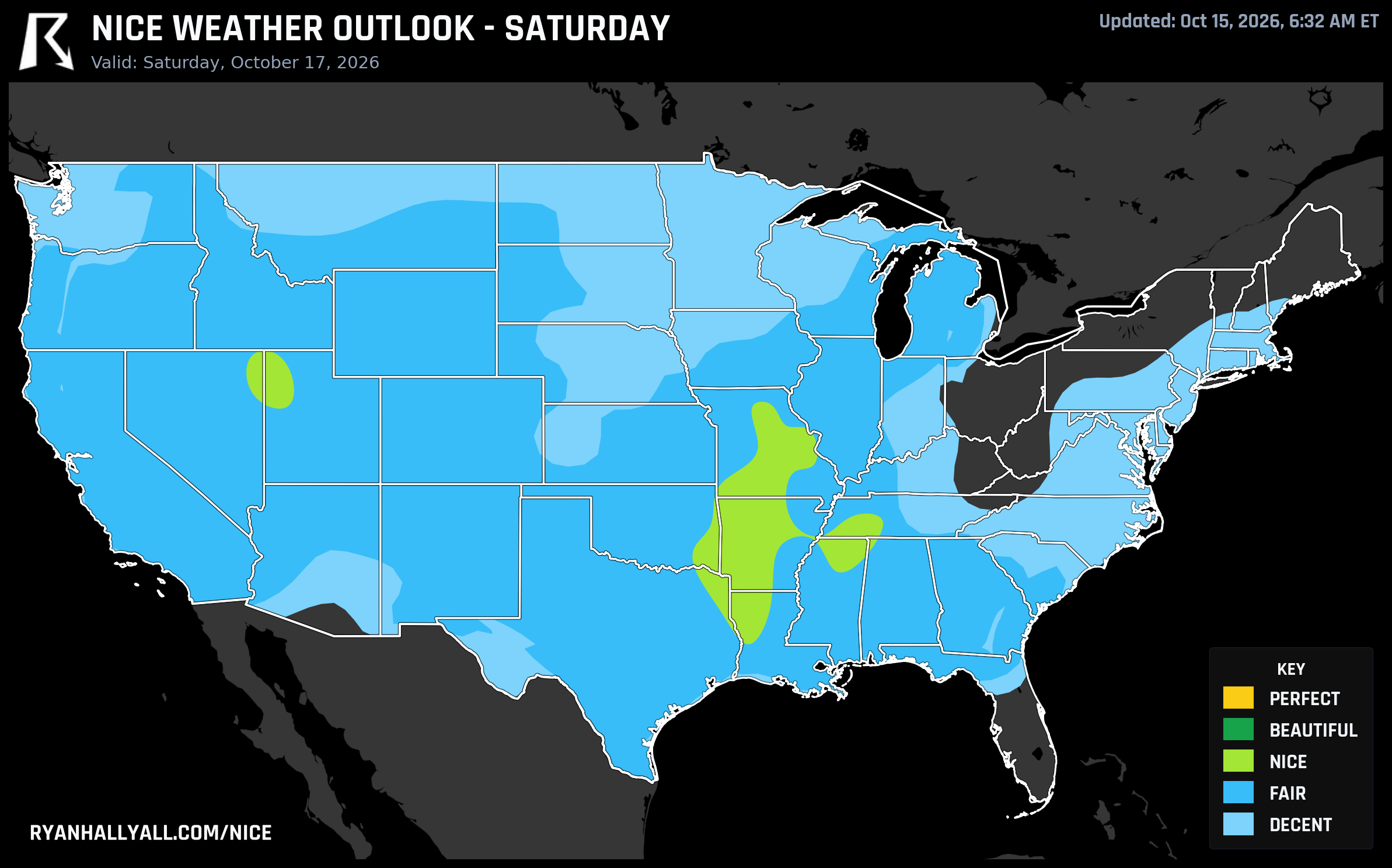
The Ark-La-Tex Has Quietly Had the Best Week in the Country
Run the full seven-day dataset and that same corridor keeps winning. Texarkana, on both the Texas and Arkansas sides, Natchitoches, Magnolia, and a string of small towns across northwest Louisiana and southwest Arkansas are logging Nice-or-better conditions all seven days, with a mean score of 79.1 and a Saturday peak that touches Beautiful. It's not a flashy pick. No beach, no ski resort, no festival headline. It's just a steady run of dry, mild, low-wind days while big chunks of the country deal with flooding, severe storms, or fire weather.
For the full picture and the latest scores by city, check the Nice Weather outlook page.
What to Watch Beyond the Weekend
The broader pattern discussion flags a useful trend for anyone planning travel into next week. The underlying quality in the Nice-capped zones actually sharpens through Tuesday, October 20, when a Chicago-to-Oklahoma City corridor posts the cleanest sub-scores of the whole outlook, 81.1 overall and just 0.9 points from the next tier, with essentially flawless dewpoint and precipitation numbers. But by Wednesday and Thursday, a deepening western trough starts pulling moisture and instability back east, and CPC's week-two outlook already flags a moderate risk of heavy rain returning to the southern Plains and Mississippi Valley around October 22. Enjoy the dry stretch while it lasts, because the pattern isn't done yet.
For now, if you're near the ridge out West, or you're willing to wait out the front into the Ark-La-Tex this weekend, this is about as good as mid-October gets.