Blog Article
East Bay's 90-Day Nice Weather Streak Holds Into Festival Weekend
The East Bay's 90-day streak of Nice-or-better weather continues as Sacramento hosts a festival, Nevada's Wendover corridor hits the day's ceiling, and Sunday peaks across the Tennessee Valley and Louisiana.
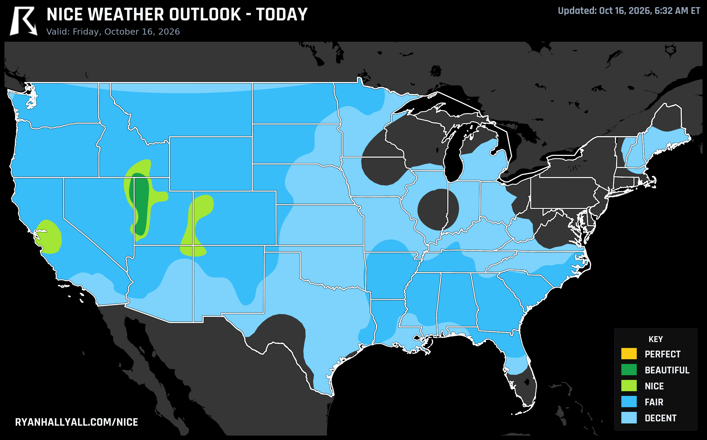
90 Days Without a Bad One: The East Bay's Streak Rolls Into Festival Weekend
Some weather stories are about a single dramatic day. This one's about ninety of them in a row.
Oakland, Berkeley, Hayward, Concord, Vallejo, Fairfield, Antioch, Vacaville, San Leandro, Livermore, Napa, Alameda, San Ramon, Pleasanton, Union City, Walnut Creek, Pittsburg, Castro Valley, Brentwood, and Dublin are all riding a live streak of 90 straight days at Nice tier or better, dating back to mid-July. That's not a typo and it's not a fluke of one mild week. It's three months of East Bay mornings and evenings where the weather simply never got in anyone's way.
Today keeps the streak alive without much drama. High pressure is holding firm over California, and the broader Nice-tier footprint on today's map actually spreads well beyond the East Bay itself. San Jose leads the state at a score of 80.5, Sacramento comes in just ahead of it at 80.9, Stockton sits at 78.4, Merced at 79.2, and San Francisco and Salinas round out the coastal side at 70.7 and 71.9. Cloud cover across this zone is averaging just 2 percent, rain chances are essentially zero, and the air is clean, with max AQI readings in the 40s.
That clean, calm air lines up nicely with the Parking Breakaway Music Festival crowd gathering in Sacramento this weekend. A two-day outdoor festival wants exactly what today's Sacramento forecast is offering: dry ground, light wind, and nothing in the sky to worry about. If you've got a lawn chair and a wristband, you picked a good weekend.
One caveat worth flagging before anyone assumes all of California is coasting. Down in western L.A. County, Ventura County, and southeastern Santa Barbara County, the Storm Prediction Center has a Critical fire weather area up today, with offshore winds and dry fuels driving real concern, a completely different story from the calm, moist marine influence keeping the Bay Area's streak alive. California is a big state, and today it's split almost exactly down that line.
Nationally, the bigger theme limiting a lot of the country isn't rain, it's wind. A severe thunderstorm risk stretches from the Mid-Atlantic into southern New England today, with damaging gust potential and an isolated tornado threat, while Florida is dealing with its own flash flood concerns. Out across the central Plains and Midwest, gusts topping 35 mph are capping a huge swath of the map at Decent regardless of how nice the temperatures look on paper. If you're anywhere between Kansas City and Chicago today, expect a breezy, workable day rather than a calm one.
The Real Ceiling Today Sits in a Tiny Corner of Nevada and Utah
If you want the single best pocket of air in the country today, it isn't California. It's a small stretch right on the Nevada-Utah-Idaho border: West Wendover, Nevada, and Wendover and Oakley, Utah and Idaho's border towns post the day's only Beautiful-tier reading. Highs sit in the low 60s, lows near 40, winds under 8 mph, and cloud cover averaging just 9 percent. The UV index runs around 5.4, so a little sun protection for a midday hike is still worth packing, but this is about as clean a fall day as the outlook produces anywhere.
Right next door, the broader Intermountain West corridor, Salt Lake City, Grand Junction, Twin Falls, and Farmington, lands in Nice tier, just shy of that top bracket. Salt Lake, Twin Falls, and Farmington all post scores around 82, with Grand Junction trailing a bit at 72 thanks to a cooler 54-degree high. Precipitation and sky conditions are essentially perfect across this whole region. The only thing holding it back from the top tier is a touch of extra humidity and a degree or two of missing warmth, which is a pretty good problem to have in mid-October.
Circle Sunday: Tennessee Valley, Ohio Valley, and a Piney Woods Corridor That's Been Nice All Week
Looking two days out, Sunday, October 18, is shaping up as the best day of this stretch, and it belongs to a different part of the country entirely. A dry, post-frontal air mass settles in across the southern Great Lakes, Ohio Valley, Tennessee Valley, and ArkLaTex, pushing Huntsville, Knoxville, Chattanooga, Beaumont, Tyler, Rogers, Murfreesboro, Joplin, Monroe, and Alexandria into Beautiful territory. Skies clear out to roughly 7 percent cloud cover, winds stay light, and dewpoints drop into the 30s and low 40s for that crisp, dry-fall feel. Bring a jacket for the morning, though. Frost is likely in the higher terrain of Tennessee, North Carolina, and Virginia.
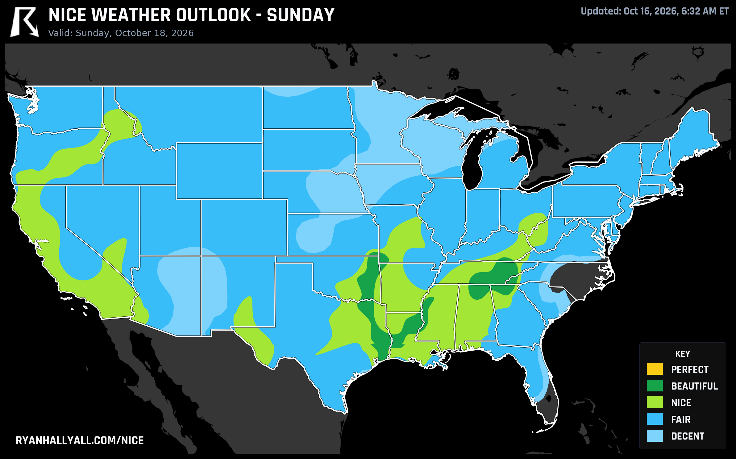
The quieter story underneath that headline is a stretch of small towns across central Louisiana and the Ark-La-Tex that's had a remarkable week. Alexandria, Pineville, DeRidder, Leesville, the Fort Polk communities, Ball, New Llano, and Rosepine have all qualified as Nice or better every single day this week, with a mean score of 80.6 and a peak into Beautiful territory on Sunday. That's seven for seven in a stretch of the calendar that's thrown flash flooding, tornadoes, and 80-plus mph wind gusts at other parts of the country. This little piney woods corridor just kept having good days.
Looking Past the Weekend
The broader pattern behind all of this is a ridge of high pressure building across the eastern half of the country, with the CPC's 6 to 10 day blend showing a strong positive height anomaly settling in over Ontario. That keeps Days 4 and 5 running close to their forecast-confidence ceiling, with scores hovering just a point or two below where they'd otherwise land. But a transient trough digging into the Southwest and Great Basin starts nudging cloud cover and wind up by Day 6, with the first thunderstorm mention of the week showing up that day and rain becoming the main limiting factor by Day 7, especially along the coast of California.
Farther out, the WPC's extended discussion flags a possible East Coast coastal low developing early to mid next week, and CPC's week-two hazards outlook is already watching a storm forming in the lee of the Rockies that could bring heavy precipitation to the Plains and Mississippi Valley, plus mountain snow, around October 23 and 24. None of that changes this weekend's plans, but if you're booking anything for the back half of next week, keep an eye on it.
For the day-by-day breakdown of where the good air is sitting, the Nice Weather outlook page tracks all of this as it updates, streaks included.