Blog Article
Sunday-Monday Bring Beautiful Weather Before Western Storm Moves In
A ridge delivers back-to-back Beautiful days Sunday and Monday from the Ohio Valley to Dallas and Nashville, before a West Coast storm cuts the good run short.
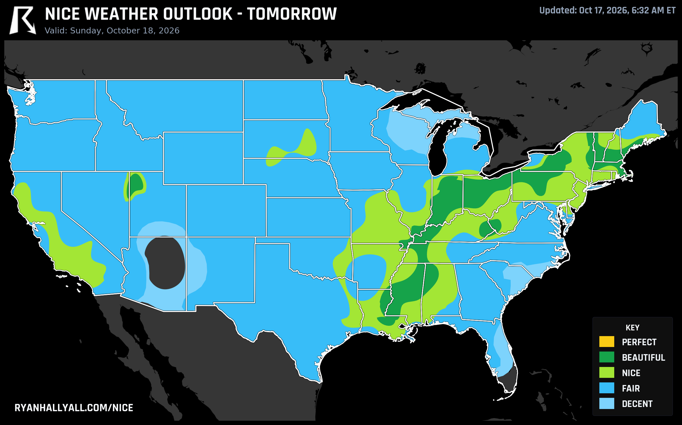
Sunday and Monday Are the Window: Two Beautiful Days Before a Western Storm Moves In
Today's lone standout is still that sliver of the Utah-Nevada line around West Wendover, sitting at a genuinely great 88.7 out of 100 under light wind and bone-dry high pressure. If you're already out that way, enjoy it. But the bigger story for the rest of the country sits one and two days ahead, when a broad ridge finally lines up over the Ohio Valley, Great Lakes, Gulf Coast, and Great Basin and holds there through Monday. That's the window worth planning around.
Sunday: Indianapolis Leads a Wide Beautiful-Tier Band
Sunday, October 18 is shaping up as the best single day of the stretch. Indianapolis tops the national list at a 92.0, with highs near 60°F, dewpoints in the upper 30s, almost no cloud cover, and wind barely topping 7 mph. Cleveland, Fort Wayne, Jackson, Syracuse, and Evansville all land in that same 82-92 range. Columbus, Boston, Dayton, and Baton Rouge round out a list that stretches from the Great Lakes down into the Gulf Coast.
Here's the interesting wrinkle. Indianapolis's raw numbers (temperature, wind, sky, precipitation) are good enough to clear the top tier outright, but an effective air quality reading of 46 keeps it from climbing any further than it already has. It's a reminder that these scores aren't just about temperature and sunshine. A clean-looking sky can still carry enough haze or particulate to cap a day's ceiling, even when every other box gets checked.
The quietly remarkable story on Sunday, though, is a string of small towns in central New York, strung along the south shore of Lake Ontario and down through the Finger Lakes: Fulton, Hannibal, Cato, Red Creek, Jordan, Weedsport, Port Byron, Auburn, Skaneateles, and Seneca Falls are all posting scores in the high 90s, among the best raw numbers logged anywhere in the country this week. If you're in that corner of the state and have apple orchards or a lakeside walk on the calendar, Sunday is the day to go. Crisp air, light wind, and a sky that should stay essentially clear.
Not every big city shares in it. A corridor of gusty wind running through the central Plains and Midwest, with some gusts topping 35 mph, keeps Chicago, Houston, and Jacksonville a notch behind the leaders even though their temperatures and humidity look fine on paper. That's the zone-average character of the day, not a guarantee everywhere inside it; Brooklyn, for instance, is individually scoring quite well despite sitting in that broader corridor.
Monday: The Ridge Shifts Toward Dallas, Nashville, and the Upper Midwest
Monday, October 19 keeps the good run going, just in a slightly different footprint. Dallas and Nashville both hit 92.0, with Las Vegas, Minneapolis, St. Louis, Madison, and Buffalo close behind. Dallas is looking at a high near 75°F with a dewpoint around 51°F, genuinely pleasant fall warmth rather than the chillier air farther north. Nashville's a touch cooler at 69°F with a dry 43°F dewpoint and wind under 6 mph.
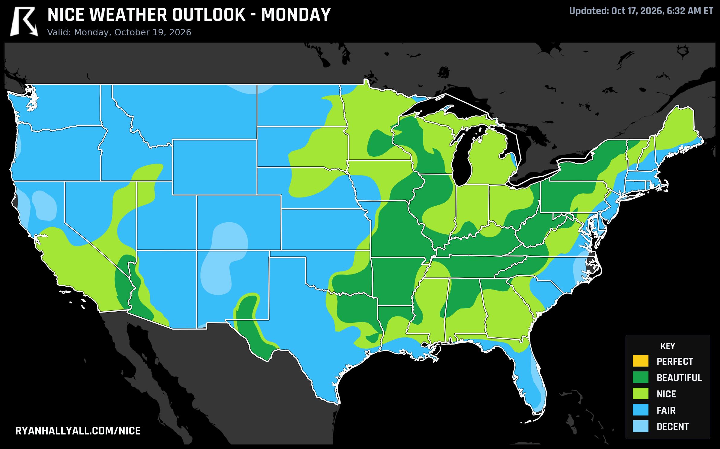
A broader Nice-tier band covers Los Angeles, Chicago, Washington DC, and Jacksonville that same day, limited mainly by slightly breezier wind and a touch more humidity than the leaders, not by anything close to bad weather. If you're headed to Austin for the Formula 1 United States Grand Prix later this week, you're sitting in the same broad Texas air mass that keeps Houston trending toward another strong day by the time the race weekend arrives.
There's also a run of small towns along the Arkansas-Missouri-Illinois-Kentucky borders, Corning, Cairo, Mounds, Bardwell, Cape Girardeau, and Carbondale among them, that haven't had a bad day all week. Every one of them has stayed at Nice tier or better for all seven days of this outlook, peaking right around that same Sunday high. It's the kind of quiet, unglamorous consistency that doesn't make headlines but makes for a genuinely good week to be outside if you live there.
Why This Window Matters: The Pattern Starts Cracking Midweek
The broader setup explains why Sunday and Monday matter so much. A mid-level ridge over the eastern half of the country is holding firm, per the latest WPC extended discussion, while a shortwave trough drops into the Rockies and Southwest later in the week. That trough widens the cloud and wind footprint across the central and western US as the week goes on. Phoenix is a good example: it sits at a solid 81.7 on Day 4 (Tuesday), then falls to 53.0 by Day 5 as cloud cover jumps to 80% and rain chances climb to 42%. San Jose, Reno, and Seattle follow a similar slide. The eastern core, by contrast, holds its Nice-tier footprint through the Great Lakes and Ohio Valley essentially unchanged all the way to Day 7.
There's also a developing nor'easter to watch along the East Coast next week, bringing wind, rain, and coastal flooding risk to the Mid-Atlantic. It won't touch the inland zones highlighted here, but it's worth knowing about if your plans run anywhere near the coast.
A couple of caveats worth carrying into the weekend regardless of where you are. Critical fire weather continues across western LA, Ventura, and Santa Barbara counties today, with 35 to 55 mph gusts and relative humidity down near 15 to 20 percent, so even a gorgeous-looking Saturday in coastal Southern California comes with real fire risk at higher elevations. And widespread frost and freezing temperatures are spreading across the Plains, Midwest, and East behind this weekend's cold air, so mornings will feel sharper than the sunny afternoons might suggest.
For the full day-by-day picture and city-level scores, the Nice Weather outlook page has the complete breakdown, and it's worth checking again midweek once that western system starts to show its hand more clearly.
Bottom line: if you've got outdoor plans this weekend, Sunday and Monday are the days to use. The pattern holds together beautifully through the Ohio Valley, Gulf Coast, and southern Plains, with central New York quietly putting up the best numbers in the country. After that, the West Coast starts paying for it while the East keeps coasting.