Blog Article
Perfect Weather Hits Wisconsin and Minnesota Monday Oct 19
A true Perfect-tier day lands in southern Minnesota and Wisconsin Monday, while a Beautiful stretch holds the Mid-South today before storms reshape the week.
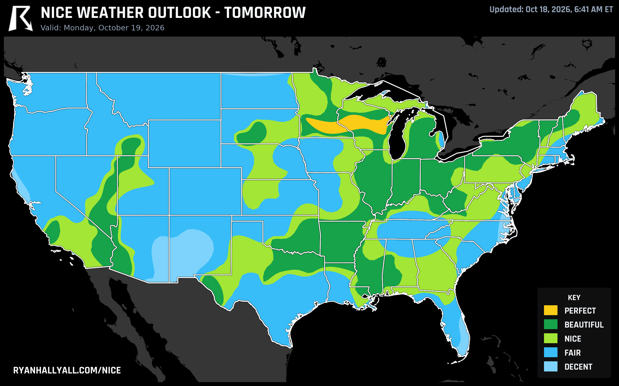
Monday's the One: A Real Perfect Day Lands in Wisconsin and Minnesota
Today's map is good. Monday's map is better. If you can only plan one outdoor day this week, move it to Monday, October 19, when a tight little zone of southern Minnesota and central Wisconsin pulls off something that doesn't happen often this time of year: a genuine Perfect-tier day, top to bottom.
Today: A Wide Beautiful Band, Mid-South to the Great Lakes
Sunday's high pressure dome is doing real work. Memphis, Jackson (MS), Shreveport, Buffalo, Syracuse, Erie, Lancaster (CA), and Victorville all land at score 92 and a Beautiful rating, with Springfield (MO) and Evansville close behind in the low 80s. Memphis itself is the textbook case: a 70.0°F high, a dry 38.7°F dewpoint, wind barely moving at 7.3 mph, and next to no cloud cover. The whole zone is sitting at a composite 88.9 out of 100, which is a genuinely strong number, but it can't quite climb into Perfect territory today. The AFD discussion is blunt about why: temperature and dewpoint sub-scores are just under the gate, and the zone's air quality (AQI in the high 30s to mid 40s, with some CAMS and AirNow readings running higher) sits above the strict ceiling that tier requires.
That air quality note matters beyond the technicalities. Indianapolis is a case worth flagging on its own. Pleasant 59.7°F highs and clear skies, but an AirNow AQI reading of 138 for part of the day, well into unhealthy-for-sensitive-groups range, tucked inside an otherwise comfortable swath of the map. If you're sensitive to particulates, check local AQI before a long run there today regardless of how nice the sky looks.
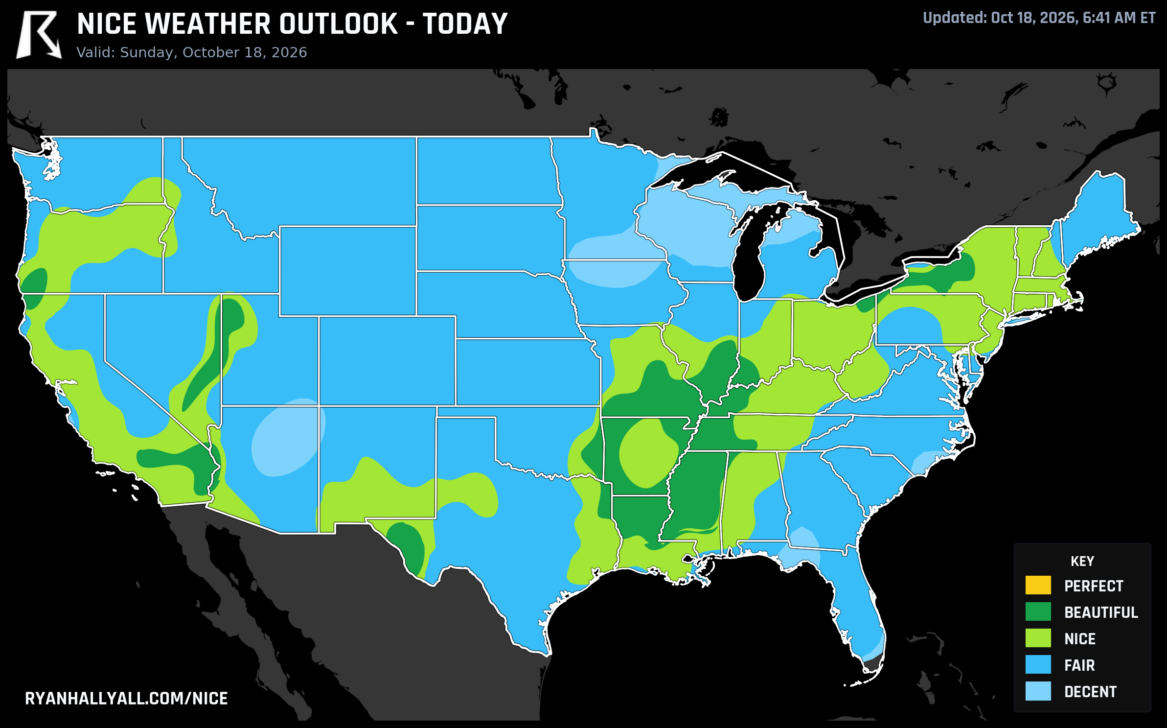
Monday: The Real Standout
Monday is the day worth circling. A narrow core across southern Minnesota and central Wisconsin, think Green Bay, Eau Claire, Oshkosh, Eagan, Mankato, and Wausau, clears every gate for a true Perfect rating, scoring 97.2 as a zone with individual cities like Green Bay (99.5) and Oshkosh (99.4) about as close to flawless as this scoring system gets. Highs land near 61-62°F, dewpoints sit in the upper 40s, cloud cover averages just 10 percent, and wind stays polite at 8.5 mph with gusts to 18. Air quality is genuinely clean, AQI near 33. The only thing to pack is a jacket for the cool start; mornings dip into the 30s and 40s before that sunshine takes over.
Widen the lens and Monday still looks great. Dallas, Indianapolis, Columbus, Las Vegas, Minneapolis, and Syracuse anchor a broad Beautiful-tier band at a zone score of 88.5, with highs near 67.7°F and dewpoints in the low 40s. The only thing keeping that zone from joining the Perfect club is a dewpoint sub-score a hair under the required floor and an AQI that creeps a little too high in spots, not temperature, not wind, not sky.
Don't sleep on the coasts and upper Midwest either, but temper expectations there. A smoke and ozone gradient is riding along with this pattern, with CAMS readings forecast as high as 160 to 177 embedded in otherwise good-looking air, and a departing coastal low is clipping parts of the East Coast with gusts over 35 mph. Both of those hold big stretches of the Plains, Midwest, and both coasts down a tier or two even though temperatures and rain chances look fine on paper.
Tuesday Keeps Beautiful Alive, Just Farther South
By Tuesday, October 20, the best air relocates to a corridor running from north Texas and Kansas City through the Ohio Valley and into the interior Southeast. Kansas City, Cleveland, Charlotte, New Orleans, Lexington, and Henderson post Beautiful scores at or near 92, with Kansas City's 71.5°F high and 47.8°F dewpoint a good representative. Dallas and Jacksonville are also in the Beautiful tier, but just barely, sitting right at the gate floor thanks to patchier clouds (43 percent in Dallas) and an AQI reading of exactly 50 in Jacksonville, the literal ceiling for that category.
Same broad caveat as Monday applies here too. A max CAMS smoke/haze reading near 172 is baked into an otherwise comfortable-looking corridor spanning the West Coast, upper Midwest, and East Coast, which is why that enormous footprint stays capped at Fair or Nice instead of climbing higher. Philadelphia is the day's weak link in the East, with gusts to 31.8 mph tied to the same offshore nor'easter that's been bringing coastal flooding and beach erosion risk to the Mid-Atlantic coast since the weekend.
The Back Half of the Week: Ceiling Drops, But the Plateau Holds
From Wednesday through the weekend, the national ceiling settles at Nice, a function of the Day 4-7 forecast rule rather than a sudden collapse in weather quality. What's actually interesting is how steady the middle of the country stays through it. A corridor running Ohio Valley into the Mid-Atlantic and down into the Gulf Coast, think Houston, Philadelphia, Indianapolis, Jacksonville, Columbus, Charlotte, Memphis, Washington DC, and Nashville, holds scores in the 79 to 82 range essentially every single day, limited only by dewpoint and temperature sub-scores sitting just under the next gate. If you've got outdoor plans tied to the Formula 1 United States Grand Prix in Austin later this week, that broader Gulf Coast and Texas swath is riding inside this same stable plateau, even if Austin itself isn't topping any single day's list.
The real action is on both coasts. A Pacific system pushes into California on Wednesday, with LIFR conditions expected at Southern California airports and Phoenix sliding to a rough 50.7 that day as clouds build to 67 percent and gusts near 22.5 mph. A Mountain West storm follows by Thursday and Friday, and a non-tropical low organizes off the Southeast coast through the period. The clearest fingerprint of all this: severe gust coverage in the weakest tier climbs from just 2 percent of the zone on Wednesday to 16 percent by Saturday. Heat stress stays a total non-issue the entire stretch, this is purely a wind, sky, and rain story.
The Quiet Winner of the Whole Week
If you'd rather not think about any of this day to day, there's an easy answer. Jackson, Mississippi, and its surrounding towns, Meridian, Pearl, Madison, Clinton, Ridgeland, Brookhaven, Byram, and more, post the single best full-week average in the country at a mean score of 86.3, with Nice-or-better conditions logged on all seven days. Its best day is today, a clean 92, and it simply never has a bad day on this particular stretch. For the full rundown of where the week's best air is sitting day by day, the Nice Weather outlook page has the current national picture.
Things Worth Keeping in Mind
The dry air making all of this possible is a double-edged sword. It's genuinely pleasant for being outside, but that same dryness keeps fire weather concerns elevated across the Mid-South and Gulf states, and critical fire weather flares up over northeastern California, southern Oregon, and northwestern Nevada as winds strengthen ahead of Monday's Pacific system. UV runs moderate most days, generally 4 to 5, so sunscreen still earns its keep on a long afternoon outside. And if your plans involve the Mid-Atlantic coast, that offshore nor'easter is bringing coastal flooding and beach erosion risk into Tuesday regardless of how nice it looks a few miles inland.