Blog Article
The Perfect Weather Pocket Tracking Across the High Plains This Week
A rare Perfect-tier air mass moves from Nebraska and Colorado into South Dakota this week, while air quality, not temperature, keeps most of the country capped below it.
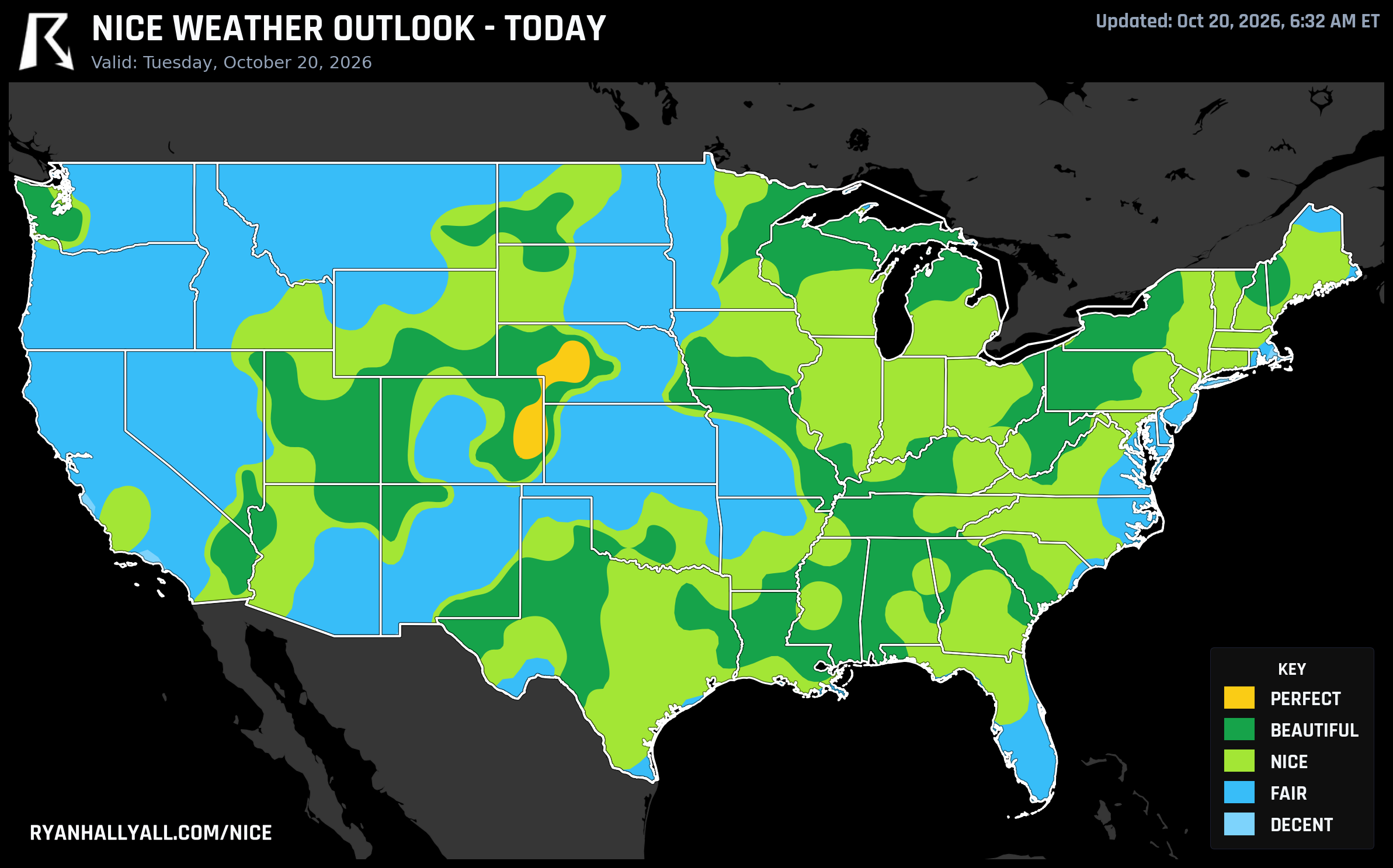
Watch the Perfect Pocket Walk Across the High Plains This Week
Most days, the best weather in the country just sort of sits there. This week it's actually walking somewhere, and you can trace its steps on the map.
Tuesday's single Perfect-tier pocket is a narrow stretch of the central High Plains: North Platte and Mullen, Nebraska, plus Lamar, Burlington, and Julesburg, Colorado. Burlington is today's national best at a 99.0, with highs near 71 degrees, dewpoints in the mid-40s, winds under 10 mph, and cloud cover so thin it barely counts. AQI there is a clean 34 to 35. If you're anywhere near that corridor today, it's genuinely as good as fall gets: patio breakfast weather, trailhead weather, let-the-dog-run-off-leash weather. The only asterisk is patchy morning fog along the Curtis-North Platte-Thedford corridor, which should burn off by mid-morning.
Here's the part that makes this week interesting. By Wednesday, that same pocket of flawless air doesn't fade out, it moves. The Perfect tier relocates about 300 miles north and slightly west, landing over the western and central South Dakota High Plains: Pine Ridge, Martin, Wall, Kadoka, and Murdo. Same recipe, dry high pressure, light wind, low 60s highs, dewpoints near 44, AQI around 30. It's basically the same air mass walking up the map a day later.
What's just as telling is everything around that pocket. On both days, a huge swath of the Plains, Midwest, and East is sitting on weather that is, by the numbers, Perfect-caliber. Tuesday's broader zone, Omaha, Nashville, El Paso, Henderson, Buffalo, clears every single comfort threshold for temperature, wind, sky, and humidity. Wednesday's version does the same for Charlotte, Memphis, Oklahoma City, Omaha, and Cleveland. But none of them crack the top tier, because the air itself isn't clean enough. Nashville's AirNow reading sits at 59. El Paso's at 62. The regional haze backdrop running through the Plains and Midwest, embedded smoke and pollution pockets that spike AirNow readings as high as 177 in spots even while the broad average looks fine, is the single thing capping huge, otherwise gorgeous stretches of the country at Nice or Fair instead of Beautiful or better. It's a good reminder that a sunny, 70-degree afternoon can still be worth a quick AQI check before a long run or an asthmatic kid's soccer game.
Thursday Pulls the Ceiling Down, But Not the Comfort
Thursday is a forecast-day cap day, meaning Beautiful is the best anyone gets nationally regardless of how clean the numbers look. That ceiling lands over the central Great Lakes and Ohio Valley, with Kansas City and Huntsville both posting a 92.0, and Charlotte, Richmond, and Buffalo trailing just behind with crisp, low-cloud, 70-degree afternoons. It's a genuinely lovely day for fall foliage drives and outdoor dining if you're anywhere in that corridor, even if the label on the tin says Beautiful instead of Perfect. Houston and Chicago, meanwhile, both carry effective AQI readings over 100 this week, a signal worth knowing if you've got sensitive lungs in either city.
The Weekend Shift: Clouds Build, the Good Stuff Heads Southwest
From Friday through the extended window, every zone sits under a Nice-tier cap, but the more useful story is where that Nice-tier weather actually lives. Our forecast team flags a slow-building Southwest system as the reason cloud cover climbs steadily all week, from single digits on Friday to covering over a third of the country by the following Monday. That system is the same one bringing the Southwest and Four Corners their own headaches, WPC has a Slight Risk of excessive rainfall there Wednesday into Thursday, with soaking showers possible across central and southern Arizona and into Southern California.
But once that moisture clears through, it leaves behind the week's best air. By the weekend, the strongest Nice-tier footprint has drifted out of the Midwest and Mid-Atlantic and resettled over the Southwest and the southern Atlantic coast. Los Angeles, Phoenix, San Diego, and Tucson anchor the western half of that shift, while Virginia Beach represents the coast.
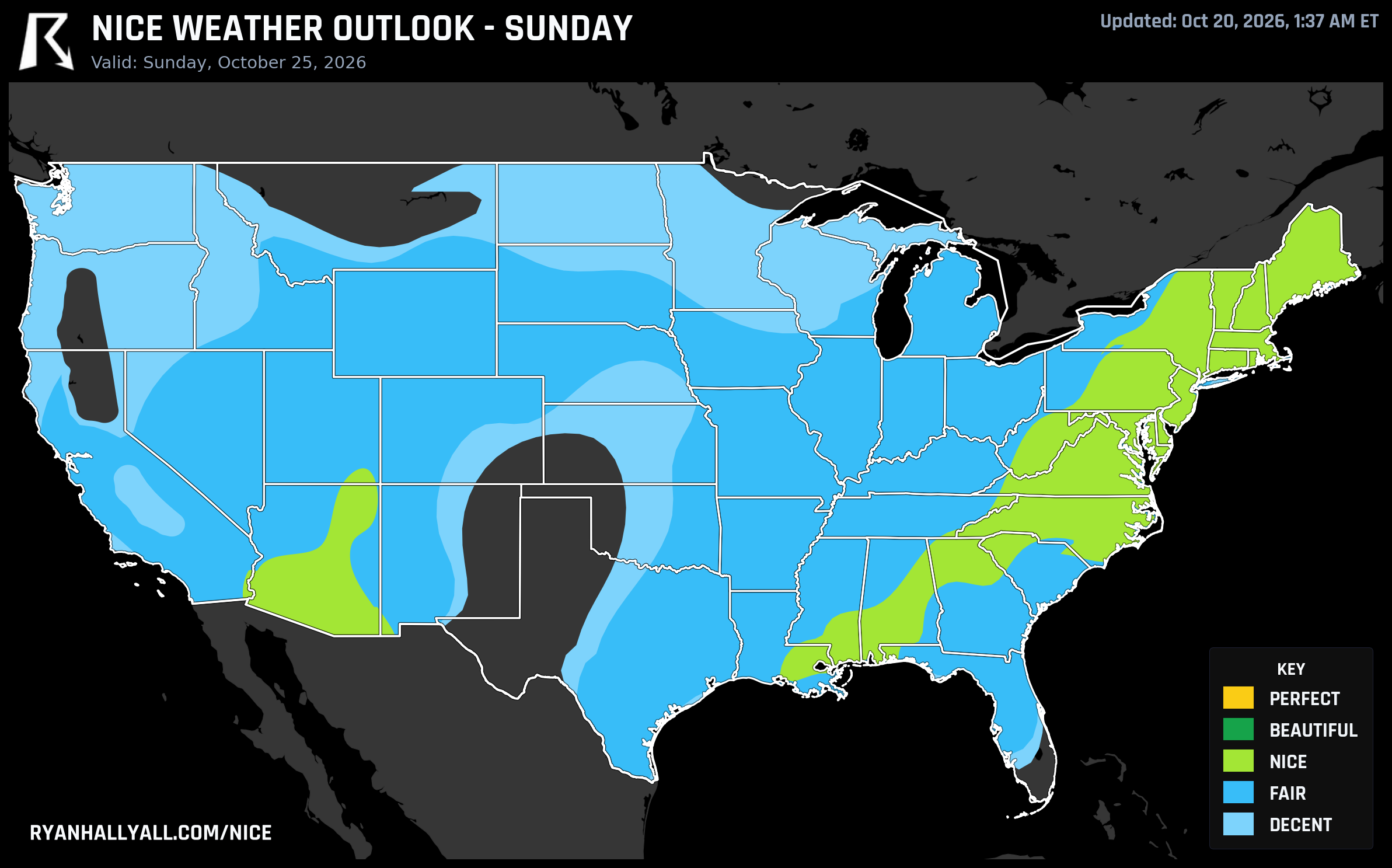
That Virginia Beach and DC-area showing lines up nicely with real plans: the Marine Corps Marathon runs through Arlington on October 25, right in the window where that corridor is scoring a solid 82 and sitting in the Nice tier, mild enough for a comfortable long run without the muggy overhang that plagues DC most of the year. It's not a guaranteed forecast ten days out, but the signal is there, and runners doing their taper this week should like what they're seeing.
One more caveat worth carrying into the weekend: this same stretch is happening while a slow-strengthening coastal low keeps the Carolina coast and Outer Banks dealing with onshore wind, beach erosion, and periodic road closures on NC 12. That's a completely separate story from the Nice Weather picture, just know that "nice inland" and "nice right on the immediate coast" are two different questions along the Southeast seaboard this week.
For the daily rundown on which cities are clearing which tier, the Nice Weather outlook page tracks it live as the pattern keeps shuffling the deck.
Bottom line for planning: if you're near the Nebraska-Colorado line today or the South Dakota High Plains tomorrow, you're getting the best air in the country, full stop. Everyone else this week is getting genuinely good weather dressed down a notch or two by haze, and by the weekend the smart money for outdoor plans shifts toward the Southwest and the southern Atlantic coast, once that system finishes wringing itself out over Arizona and Southern California.