Blog Article
Oregon's 51-Day Streak and the Blue Ridge's Beautiful Week
Southern Oregon is on a 51-day comfortable weather streak while the Blue Ridge Mountain Empire runs 7-for-7 and peaks at Beautiful today. Here's why, plus caveats.
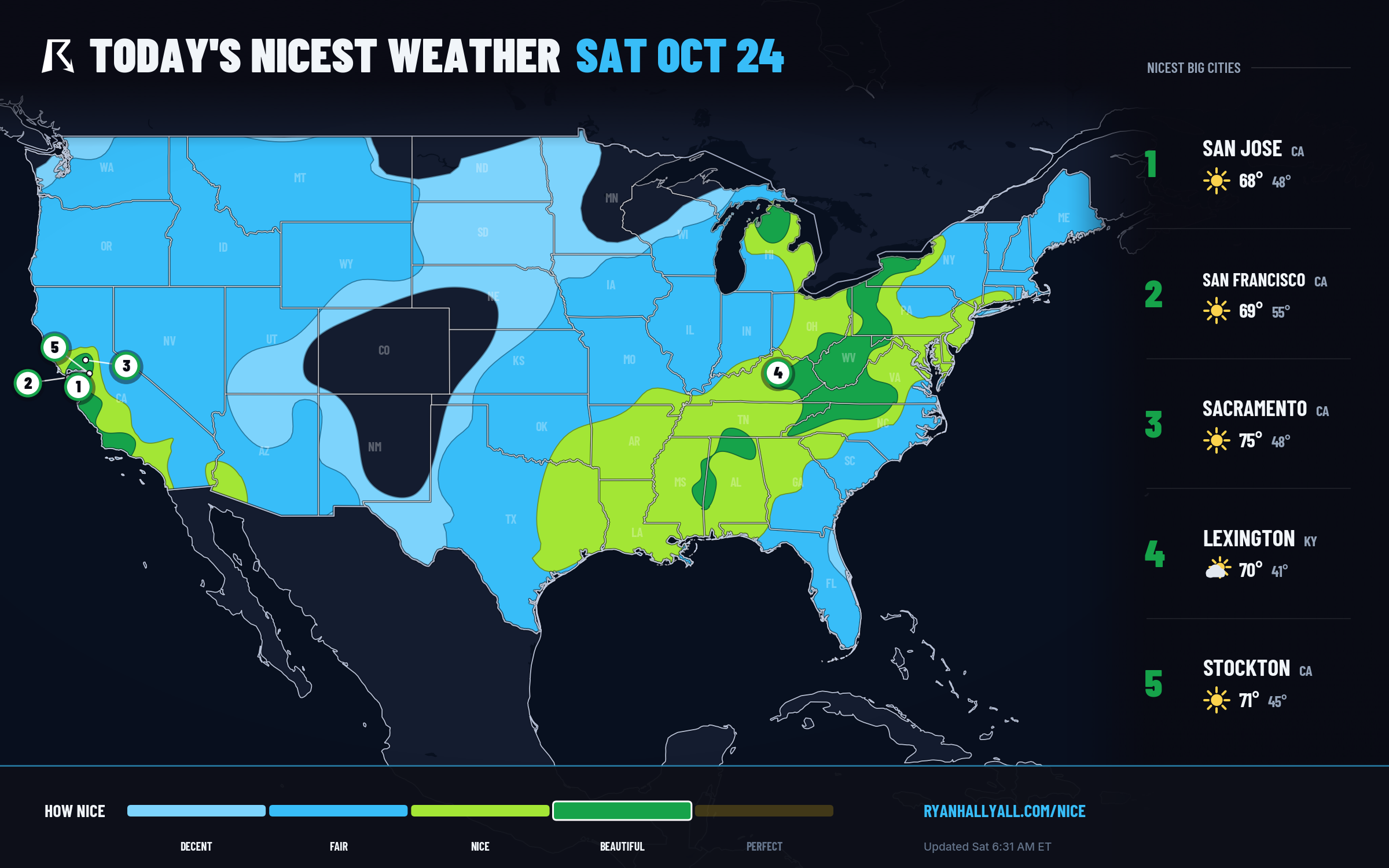
Oregon's 51-Day Streak Meets the Blue Ridge's Perfect Week for Nice Weather
Most of the weather headlines this week belong to the Southwest, where saturated ground from the San Juan River flooding is taking another round of heavy rain. That story is real and it's not over. But tucked away from all of that, two places have quietly built the kind of track record that almost never makes the news, because nothing dramatic happened. The weather was just good, day after day after day.
A Streak That Refuses to Break
Ashland and Ruch, Oregon, are sitting on a 51-day live streak of comfortable weather, the longest active run anywhere in this dataset. Talent and Phoenix, just down the road in the Rogue Valley, aren't far behind at 50 days. Zoom out to the broader Umpqua Valley and south coast and you'll find a wall of 30-day streaks: Roseburg, Coos Bay, Cottage Grove, Florence, Sutherlin, Creswell, Veneta, Reedsport, Coquille, Glide, Lakeside, Drain. Several of those towns, including Florence, Reedsport, and Lakeside, actually touched the Perfect tier as recently as October 23, yesterday, before settling back into their steady run.
This is what a stable fall pattern looks like when it just sits there and behaves. A broad ridge has kept the interior Pacific Northwest dry, mild, and clear for weeks, and nothing in the short-term pattern looks ready to kick it loose. The one thing worth watching out there isn't in today's data but it's worth saying anyway: long dry stretches like this are exactly the kind of setup that keeps fire-weather conversations alive in Oregon's interior valleys, even without an active warning on the books today.
The Blue Ridge Mountain Empire Doesn't Miss Either
On the other side of the country, a cluster of small towns straddling the Tennessee, Virginia, North Carolina, and West Virginia borders is putting together the best week in the entire outlook. Bristol (both the Tennessee and Virginia halves), Boone, Abingdon, Galax, Franklin, Blountville, Sylva, Mountain City, Damascus, Blowing Rock, and about a dozen neighbors are all Fair-or-better for all seven forecast days, averaging 84.8 out of 100, and today they peak at Beautiful with a 92.0 score.
This is the Virginia Creeper Trail and Blue Ridge Parkway corridor, and today it's about as good as outdoor weather gets this time of year. Highs near 65 to 70, dewpoints in the low 40s, cloud cover down around 8 percent, and wind barely touching 8 mph. If you're chasing fall color on the Parkway near Blowing Rock or walking State Street in Bristol, this is the day to do it.
Why Beautiful and Not Perfect
Here's the interesting part. The sub-scores behind today's Appalachian and California air are about as clean as the atmosphere gets this time of year. Precipitation and heat stress both sit at a perfect 100, sky cover is 95.9, wind is 93.8, temperature and dewpoint are both in the low 90s. Every single one of those numbers clears the bar for Perfect. What's holding the zone back is air quality: the average AQI across this corridor runs 47, with a max AirNow reading of 74, and reaching Perfect requires AQI at or below 35. It's a one-variable ceiling on an otherwise flawless day. Buffalo (58 degrees, 2 percent cloud cover, AQI 48) and San Francisco (69 degrees, 4 percent cloud cover, AQI 50) both land at 92.0 for the same reason, held one notch below the top tier by haze and particulates rather than anything about the sky or the thermometer.
Looking Ahead: Bristol to the Bluegrass
Sunday keeps the same dry ridge in place, with Richmond, Knoxville, Newport News, and Chattanooga all running Beautiful again, and the pattern holds through midweek with sky cover doing nearly all the limiting elsewhere in the country. By Day 3, the core shifts slightly west into the central Ohio Valley, and Charlotte, Raleigh, Knoxville, and Greensboro all post a clean 92.0.
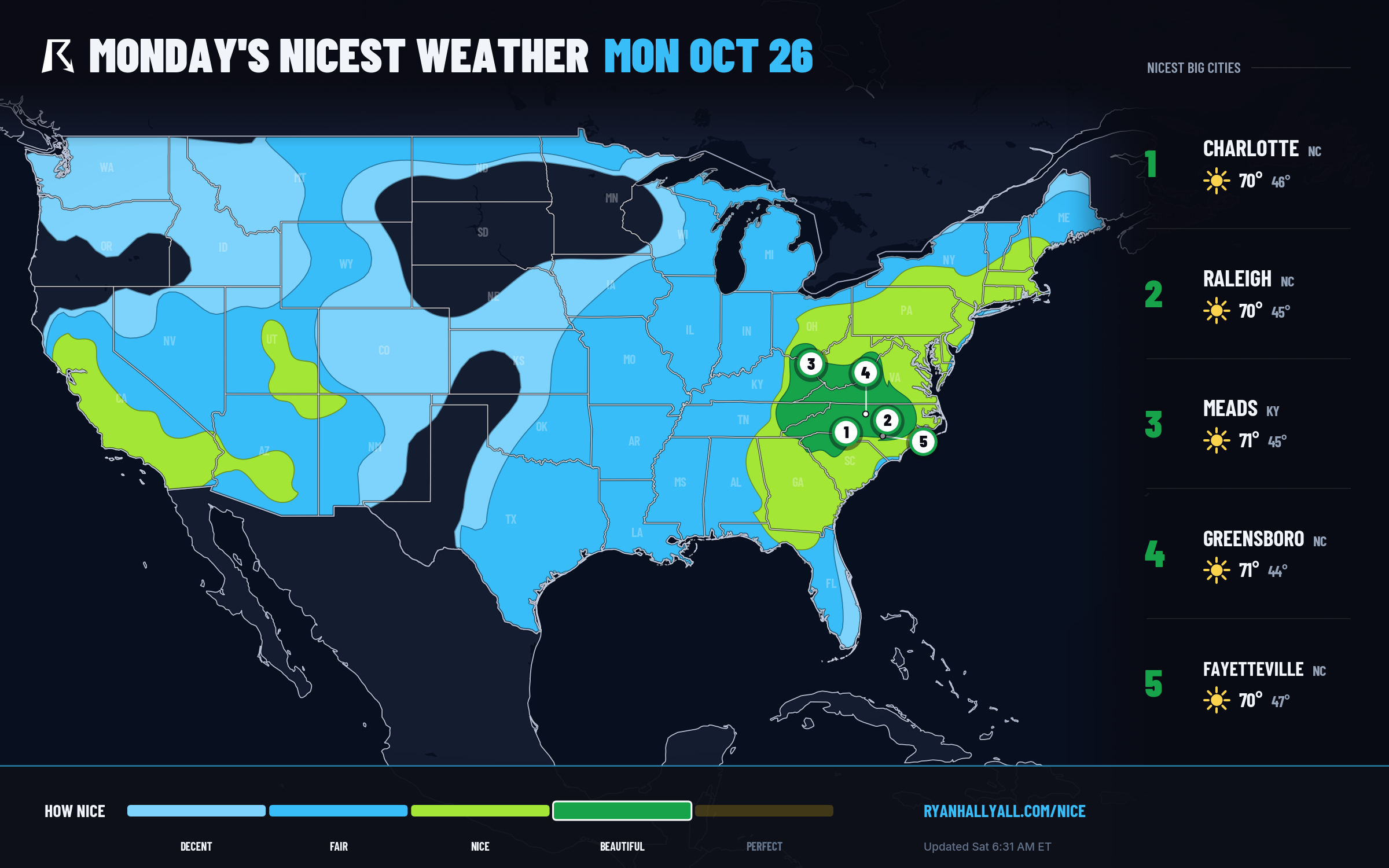
Farther out, with the usual lower confidence that comes with a six-day lead time, Day 7 shows Louisville sitting inside a Beautiful-tier zone alongside Philadelphia, Charlotte, and Boston, the same weekend the Breeders' Cup World Championships run at Lexington, just up the road in the Bluegrass. Lexington itself is forecast Nice at 82.0 that day under the extended outlook's firmer cap, but the broader regional air mass trending toward Beautiful nearby is a decent early signal for racegoers. Worth another look as the week firms up.
Worth Knowing Before You Head Out
UV sits in the moderate range across the Appalachian core, around 4.8, so sunscreen and sunglasses still earn their keep on a long hike. The same dry air that's making this stretch so pleasant is also pulling humidity down into the 25 to 40 percent range across the Southeast, which keeps fire danger elevated in spots with dry fuels, so hold off on open burning where bans are posted. Mornings in the sheltered valleys of Kentucky, Tennessee, and the Mid-Atlantic highlands can carry patchy frost, so dress in layers if you're out early. None of this takes away from the bigger picture, this is about as clean a stretch of fall weather as the map offers right now, and the full picture by state and city is on the Nice Weather outlook page.
Meanwhile, keep an eye on the Southwest. That flooding story from the Four Corners region hasn't wrapped up, and WPC still has a Slight Risk of excessive rainfall posted over parts of the Southern High Plains and Rockies today and tomorrow. It's a useful reminder that the same broad pattern keeping Oregon and the Blue Ridge so calm is also parking a slow-moving mess over New Mexico. Nice weather and rough weather, same continent, same week.