Blog Article
Nice Weather Outlook: Last Beautiful Days Before Weekend Trough
Today and Wednesday bring the week's best Beautiful-tier weather before clouds and showers take over. See where the window closes and what it means for Breeders' Cup and NYC Marathon.
Two Good Days Left Before the Pattern Turns, With the Breeders' Cup Sneaking In Under the Wire
Good morning, y'all. If you've got an outdoor plan sitting on the calendar for later this week, move it up if you can, because the data is pretty clear about where this is headed. Today and tomorrow are the good days. After that, the sky starts closing in from the west, and by the weekend most of the country is back to Fair and Decent territory.
Today: The Desert Southwest and Southeast Share the Top Spot
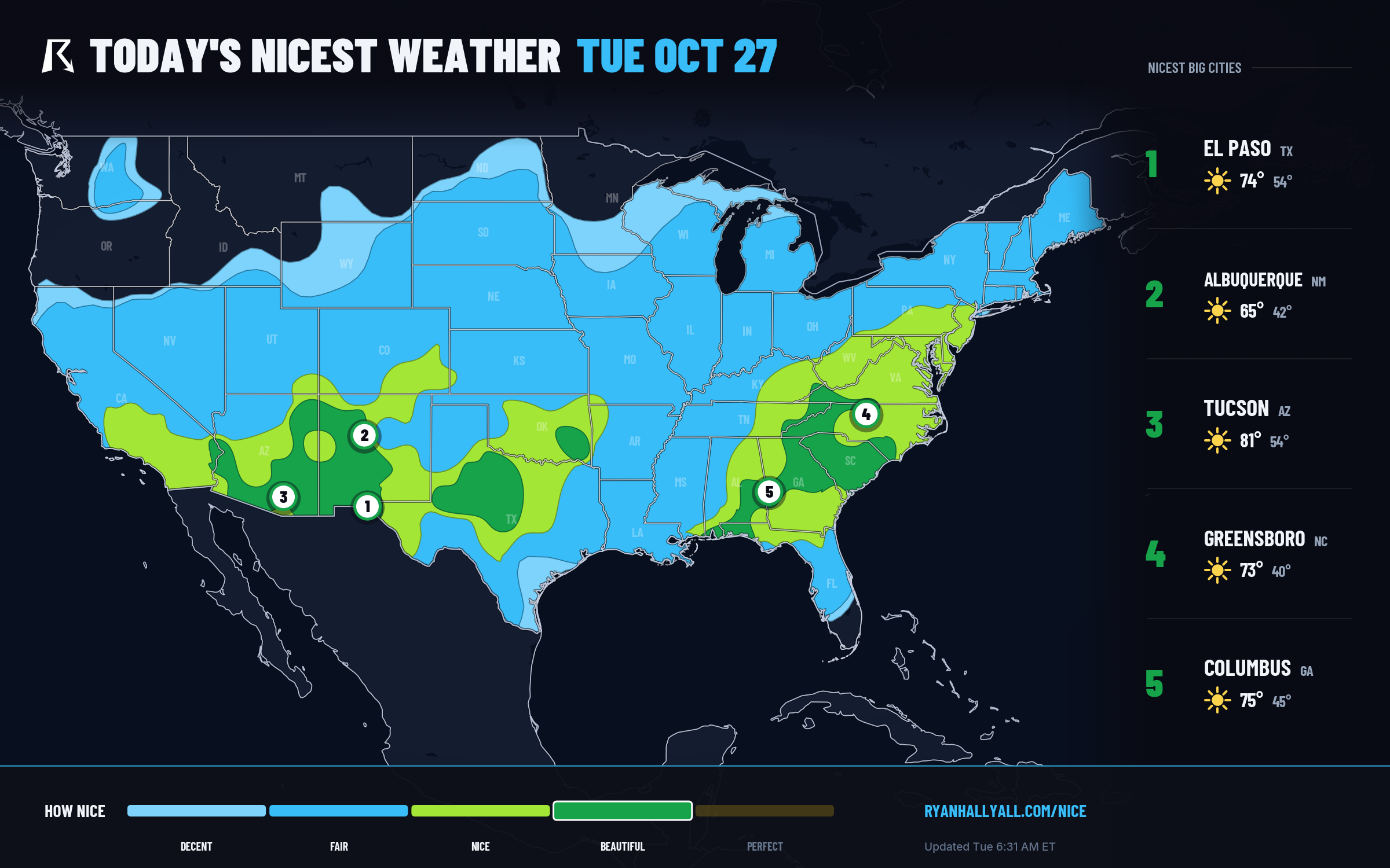
Today's ceiling is Beautiful, and it's sitting over a wide stretch of the map: southeastern Arizona, southern New Mexico and west Texas, then east across Tennessee, Kentucky, Alabama, Georgia, the Carolinas, and into the Florida panhandle. El Paso, Albuquerque, Tucson, Columbus (GA), and Montgomery are all posting clean 92s today, with highs in the mid 70s to mid 80s, dewpoints in the upper 40s, and winds light enough to not matter. Every one of those zones would technically qualify for Perfect on temperature, wind, and sky alone. Air quality, running in the mid-40s on the effective AQI scale, is the only thing holding the line at Beautiful instead of the top tier.
There's a fun footnote buried in the city-streak data too. A cluster of Louisiana towns around Lake Charles, Sulphur, Crowley, and a dozen neighbors are riding 23-day streaks of Nice-or-better weather, their longest of the season, with their last Perfect-tier day back on October 20th. That's an unusually long run for late October, and it says something about how calm the pattern has been across the Gulf Coast even while West Texas and New Mexico were dealing with flash flooding and tornado warnings earlier this week.
Tomorrow: The Baton Passes to the Plains and Mid-South
Wednesday's best weather shifts east and north into a corridor running from southeastern Colorado and western Kansas through north-central Texas, Arkansas, southern Missouri, and the western Tennessee and Kentucky corridor. St. Louis, Fort Smith, Monroe, Sherman, and Cape Girardeau all hit 92. Highs climb to around 75 degrees with dewpoints still near 49, winds under 10 mph, and only 13 percent cloud cover. Same story as today: every sub-score for temperature, wind, sky, and precipitation would clear Perfect's bar. Air quality running in the mid-40s to low-50s is again the only thing in the way.
If you're in that corridor, this is the day to take the lunch outside, hit the trailhead, or get the yard work done. It won't last.
Thursday: The Zone Shrinks, and a Flood Risk Rides Along With It
By Thursday the Beautiful tier contracts down to a small bullseye over northeastern South Dakota, southeastern North Dakota, and west-central Minnesota, where crisp 55-degree highs, 40-degree dewpoints, and nearly cloud-free skies make for genuinely excellent autumn weather, just a cooler flavor of it. A much broader Nice-tier swath still covers the Ohio Valley and Great Lakes into the Carolinas and the Northeast, including Philadelphia, Charlotte, Memphis, and Louisville, all pinned there by AQI running a few points over the Beautiful cutoff rather than anything about the actual weather.
The catch is in West and Central Texas, where WPC has posted a Slight Risk of excessive rainfall Thursday as leftover moisture from what had been Tropical Storm Vance combines with deep Gulf moisture pushing PWATs to three standard deviations above normal. That's the same general stretch of country, including El Paso and Socorro Counties, that saw deadly flash flooding and tornado warnings just this week. If you're anywhere near the Permian Basin or the Edwards Plateau Thursday, this isn't a nice-weather day. It's a watch-the-radar day.
Friday's Irony: The Best Raw Scores of the Week, Capped at Nice
Here's a strange wrinkle in the data. Friday (Day 4) actually produces the highest raw comfort scores of the entire seven-day outlook, thanks to a transient ridge parked over the Northeast and Mid-Atlantic. Philadelphia, Indianapolis, Charlotte, Washington, and Pittsburgh all land around 81, with dewpoints and precipitation scores nearly maxed out. But Day 4 is capped at Nice by the forecast-day rules regardless of how good the underlying numbers look, so it won't show up as a headline day even though, on paper, it's the week's best.
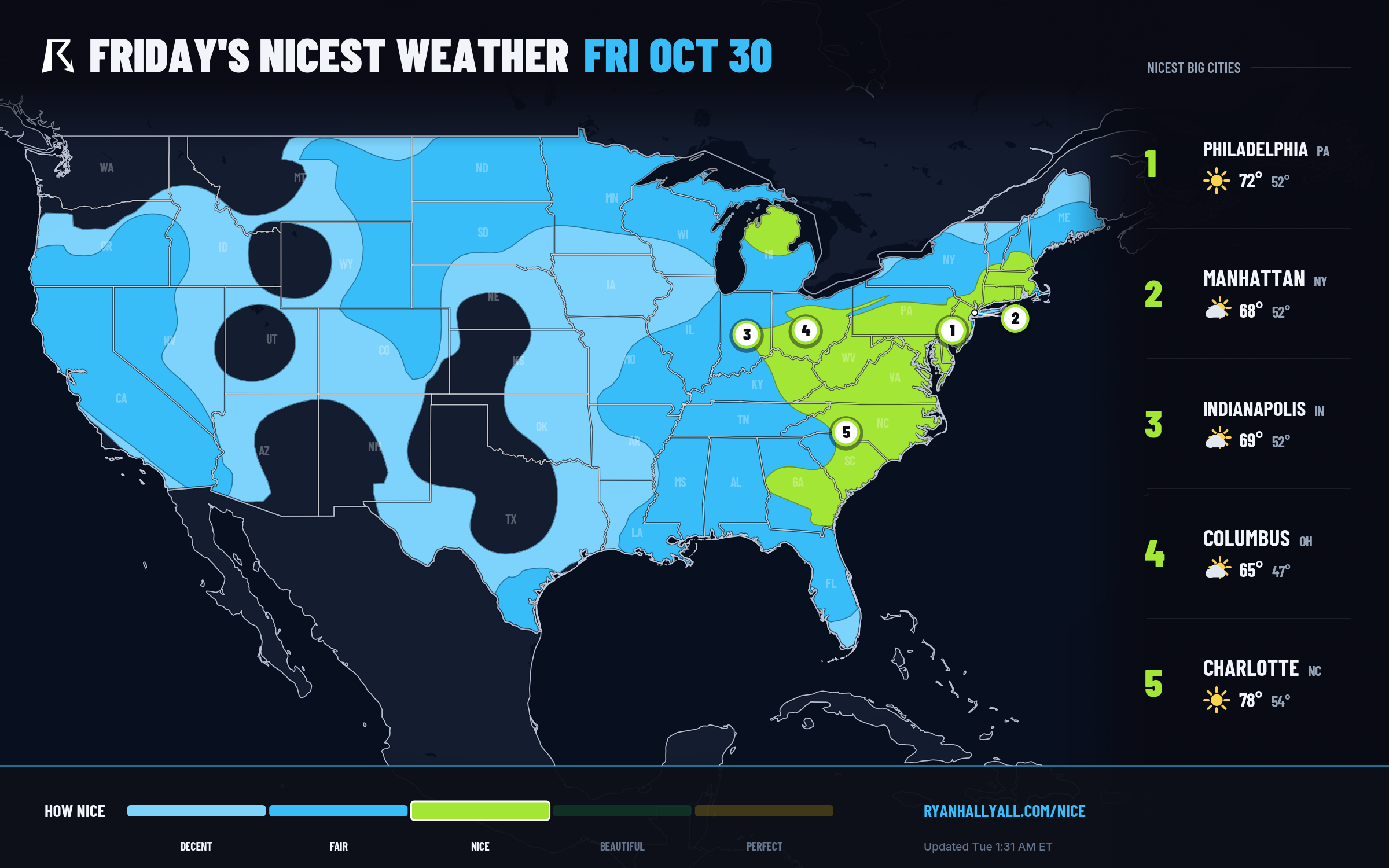
That's also the day the Breeders' Cup gets underway in Lexington, Kentucky, which sits right in that Ohio Valley sweet spot. Lexington posts an 80.5 on Friday, mild and dry with manageable wind, a genuinely pleasant day at the track even if the number never gets to flash a top-tier label.
The Weekend Drop, and What It Means for the Marathon
From there it's a fast slide. WPC's extended discussion has a deepening western trough swinging a shortwave across the central US through the weekend, and the Nice Weather data backs that up: sky scores collapse from the mid-90s into the 30s and 40s across broad stretches of the Plains, Midwest, and eventually the East Coast by Saturday and Sunday. Philadelphia's cloud cover alone jumps from 17 percent Friday to 86 percent Saturday, dropping its score from 81 to the low 70s with no rain even involved, just clouds doing the damage. By Sunday, November 1st, the day of the New York City Marathon, the Northeast sits in Fair territory with building cloud cover and rising shower chances. Not a washout as of now, but not the crisp blue-sky marathon morning anyone's hoping for either, and worth another look as the weekend gets closer.
If you want to track how this plays out day by day, the Nice Weather outlook page keeps the current map and city rankings updated as the trough gets closer. For now, the move is simple: whatever you were saving for the weekend, see if you can do it today or tomorrow instead.