Blog Article
Desert Southwest Flips From Flash Floods to Perfect Air
After Phoenix flash floods, the desert Southwest turns PERFECT by Monday. See where Las Vegas, Phoenix, and NYC's marathon-day weather line up this week.
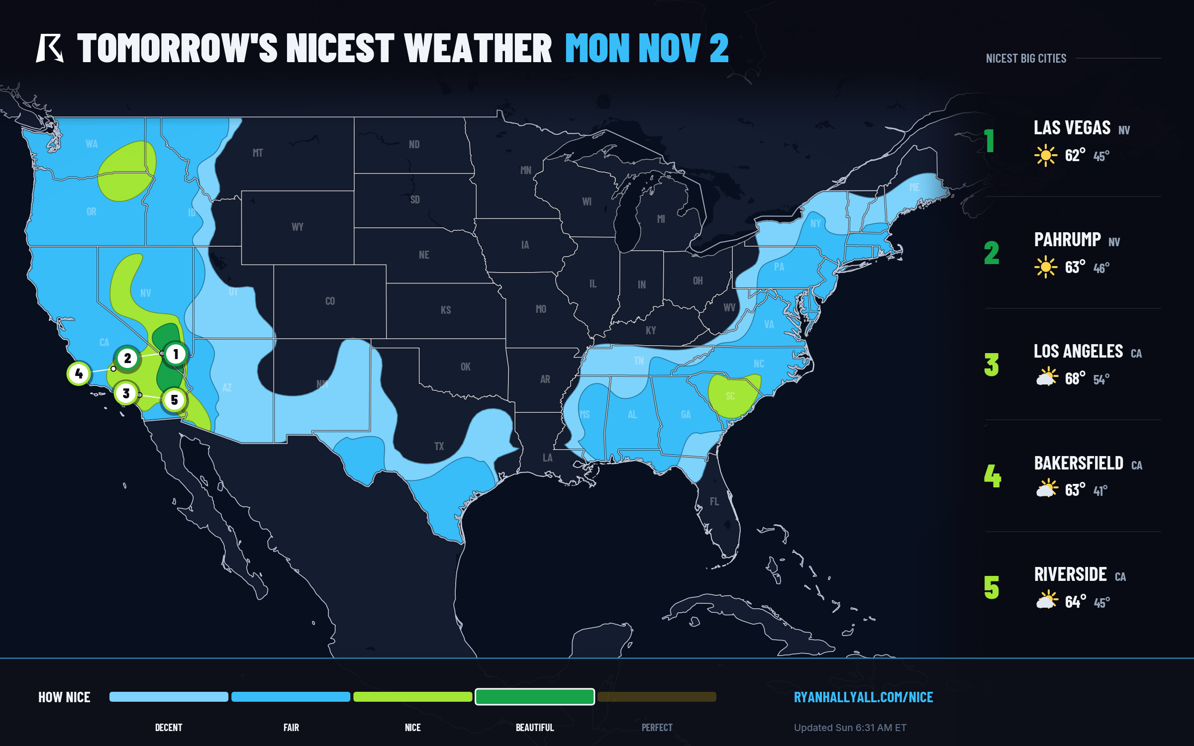
From Flash Floods to Perfect: The Desert Southwest's 48-Hour Turnaround
It's worth sitting with the whiplash here for a second. Yesterday morning, Phoenix Fire Department crews were pulling six people out of four vehicles trapped in floodwaters near 40th Street and Stanford Drive. Flash Flood Warnings turned into an areal Flood Warning. WPC still has a Moderate risk of excessive rainfall posted today for the Four Corners region, with an atmospheric river dumping precipitable water values 4 to 6 sigma above normal onto soil that's already saturated from a wet October. That's today's story in the Southwest, and it's a real one, with 2 to 4 inches possible on upslope terrain and flash flooding a genuine concern through the afternoon.
So it's a little wild that by Monday, the exact same stretch of desert is projected to post the single best weather score in the entire country.
Monday: the storm leaves, and Vegas gets perfect
Once the atmospheric river finally pushes off to the east, high pressure builds in behind it, and the air over southern Nevada, the southern California deserts, and northwestern Arizona dries out fast. Monday's data puts Las Vegas, Henderson, Searchlight, and Alamo at a 92.0 score, the outlook's PERFECT tier. Highs run near 63°F with dewpoints in the low 40s, winds a manageable 11 mph, skies only 17 percent covered, and AQI down around 39. UV sits at a moderate 5, so sunscreen and a hat still earn their keep, but otherwise this is about as clean an early-November day as the dataset produces anywhere.
One honest caveat: trails and washes around southern Nevada and adjacent Arizona may still be wet or muddy from the weekend's rain, so give low-lying desert routes a day or two before you trust them fully. And if you're farther east toward the southern High Plains, keep an eye on the sky. SPC has a Slight risk of severe storms, including a tornado threat, lined up for Monday evening from Oklahoma into north Texas, well away from the calm desert air but close enough that travelers crossing the region should check the latest outlook before driving through.
Tuesday: the same ridge, a broader footprint
The pattern doesn't fold after one good day. Tuesday's outlook keeps a BEAUTIFUL ceiling across the southern Rockies and Intermountain West, with Phoenix, Tucson, El Paso, Sierra Vista, and the Chula Vista and San Diego coast all scoring in the 81 to 92 range. Winds stay light near 7 mph, skies run just 16 percent cloud cover, and dewpoints hold in the low 40s. Clovis, New Mexico, posts the single best number in that whole stretch at 92.0, driven mostly by calm wind and genuinely dry air rather than any particular warmth. None of this is heat-stress weather either; highs average a mild 69°F, cool mornings and comfortable afternoons, exactly the kind of range that's easy to spend all day outside in.
Zoom out across the full week and this isn't a one-day fluke. The Nice Weather outlook page weekly rankings have small desert towns like Calexico, Blythe, Ehrenberg, and Quartzsite logging NICE-or-better conditions on six of the next seven days, anchored by that same Monday PERFECT reading. It's a quiet confirmation that the ridge building in behind this storm has real staying power, even if the exact day-to-day boundary between NICE and FAIR farther north and east stays fuzzier the further out you look.
Meanwhile, today's best air is 2,500 miles away
Today's own NICE zone sits far from the desert drama, stretched from greater Seattle and Portland through northern California and into the interior Northeast, including eastern New York, Vermont, Connecticut, and northeastern Pennsylvania. Manhattan and The Bronx post the strongest scores in the country right now at 92.0, with highs near 59°F, light wind, and dewpoints in the upper 30s keeping things crisp rather than clammy. That matters today specifically because the New York City Marathon is running right through it, and runners should get a cool, dry, mostly sunny morning with winds light enough not to be a factor. Seattle and Portland sit a touch cooler in the high 70s score range, with morning fog the only real complication before afternoon clearing.
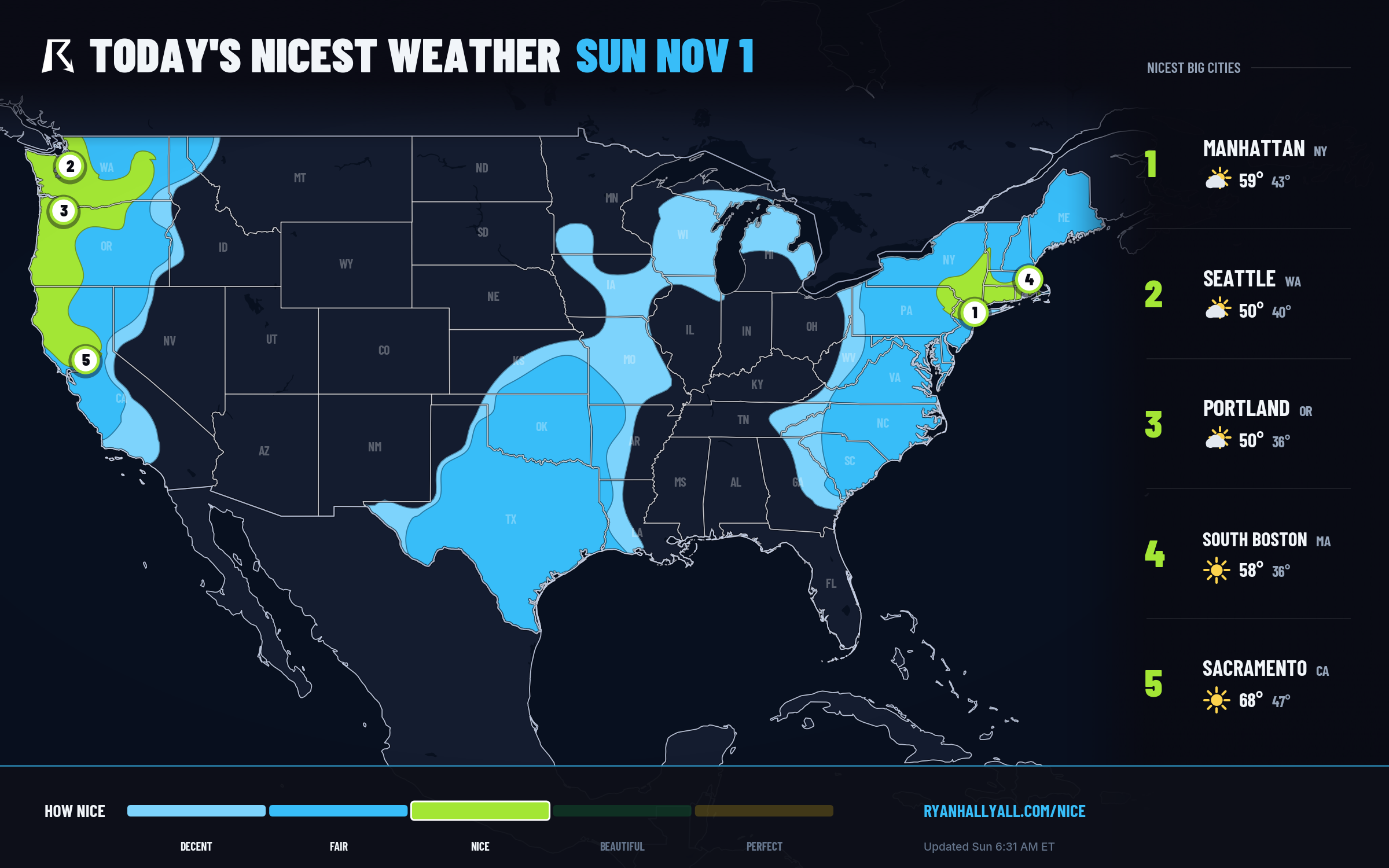
That Northeast and Pacific Northwest corridor tops out at NICE rather than BEAUTIFUL today, and the reason is almost entirely temperature and dewpoint. The sub-scores for wind, precipitation, and sky are all in the 90s, but highs averaging 54°F and dewpoints near 39°F just aren't quite warm enough to clear the next tier's threshold. It's a good day, not a flawless one, and that's a fair way to describe most of the country outside the desert Southwest this week: cloud cover and cool November air are the limiting factors almost everywhere, while the storm-clearing Southwest gets to borrow the week's only truly exceptional stretch.
So if you're planning outdoor time through midweek, the desert is where to point the compass, mud on the washes notwithstanding. Everyone else gets a solid, cool, mostly dry run of days, just not the kind that cracks the top tier.