Blog Article
San Gabriel Foothills Top Nice List, Face Fire Weather Risk
Glendora and Covina lead the week's nice weather rankings, but a Santa Ana wind event looms. See how the weekend's best-weather zone shifts coast to coast.
The San Gabriel Foothills Are Topping the Nice List Right Into a Red Flag Warning
Y'all, here's a fun contradiction buried in this week's numbers. The highest mean scores on our entire seven-day rollup belong to a cluster of San Gabriel Valley cities most people outside Southern California have never heard of: Glendora, Covina, Azusa, Citrus, and Irwindale. All five are running a 84.7 mean score across all seven days, every single day landing Nice or better. That's about as good as the week gets anywhere in the country.
And Saturday, those same foothill towns sit right under an elevated fire weather outlook.
It's not actually a contradiction once you look at the mechanism. The dry offshore flow that keeps Southern California's skies clear and its afternoons comfortable is the exact same ridge pattern that, when it gets squeezed the right way, drives a Santa Ana event. The Storm Prediction Center's Day 2 fire weather outlook calls for a weak to moderate Santa Ana wind push into the San Gabriel, Santa Monica, and Santa Susana mountains Saturday, sustained winds near 20 mph gusting 30 to 40, relative humidity down to 15 to 20 percent, and energy release component values sitting at the 90th seasonal percentile thanks to critically dry dead fuels. That's the San Gabriel Valley. Same towns topping our list. If you're out there Saturday enjoying the sunshine, it's worth knowing the wind is doing double duty.
A Weekend Ceiling That Won't Sit Still
Away from that one caveat, the bigger story this weekend is how much the best-weather zone is migrating day by day.
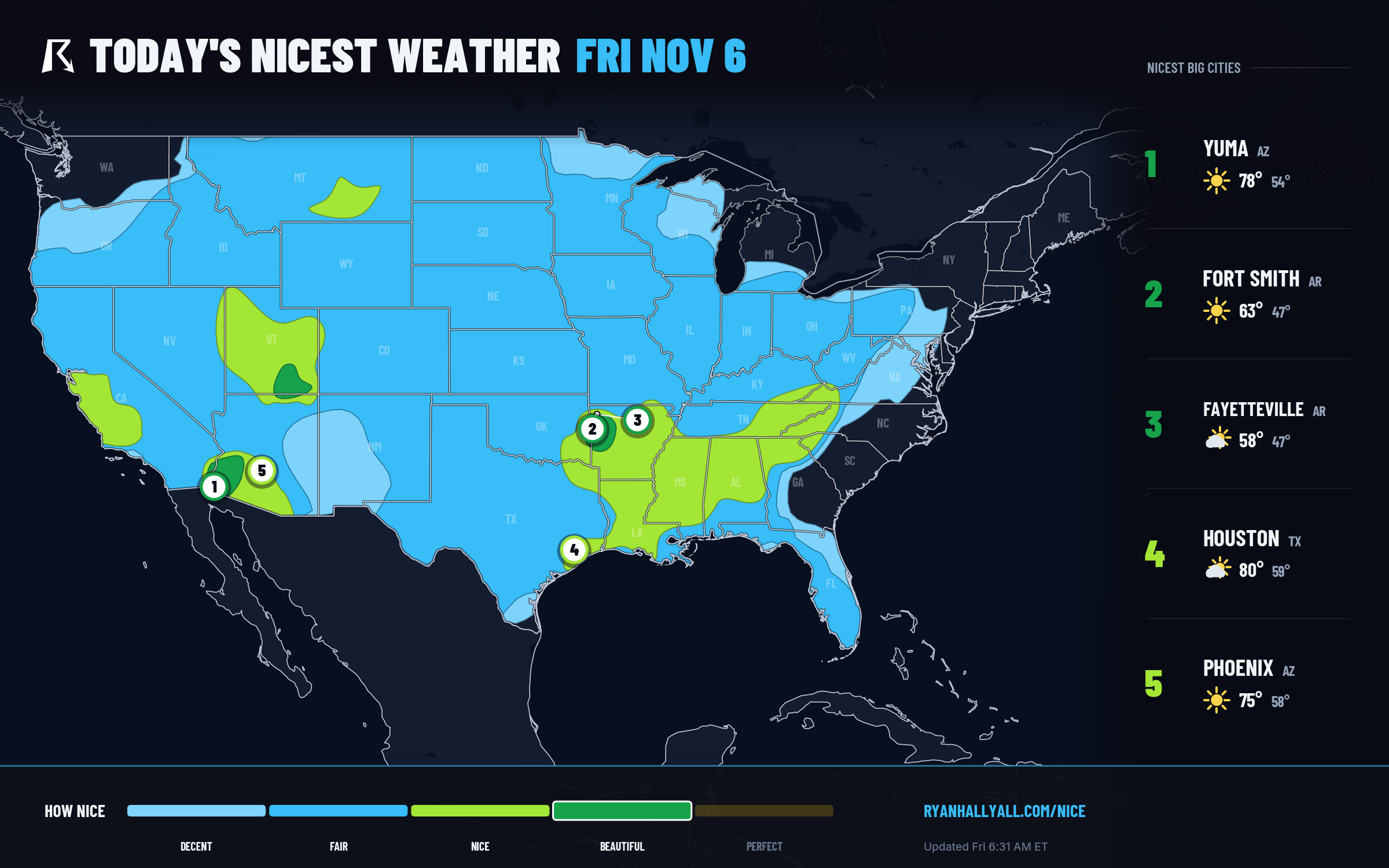
Today (Friday) the top category is genuinely narrow. A band of Beautiful conditions runs through southwestern Arizona, southeastern Utah, and the Arkansas River Valley, Fort Smith and Fayetteville, Arkansas, plus Yuma, Arizona, are the standout performers, with Fort Smith posting a 98.0 on light 8 mph wind and a comfortable mid-50s dewpoint. Nothing in the country reaches Perfect today. Wind and a touch of AQI in the desert corner, plus Phoenix's smoke-nudged air quality, are what keep even the best zone from climbing higher.
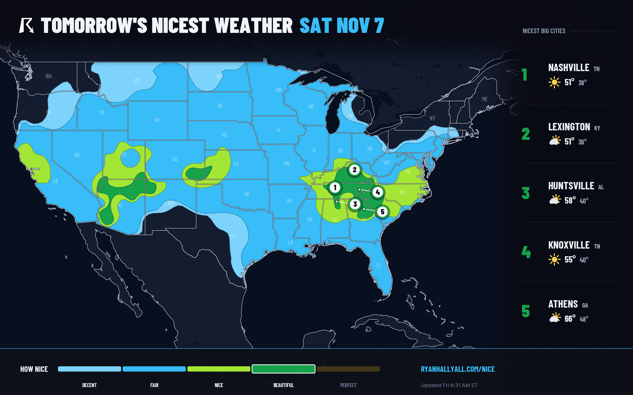
Tomorrow (Saturday) the best weather relocates entirely. The Tennessee Valley, central Kentucky, northeast Georgia, and the Carolina Upstate take over as the day's ceiling zone, scoring 88.6, with Nashville, Lexington, Huntsville, Knoxville, Athens, and Asheville all landing Beautiful marks. It's a crisp, dry setup, cloud cover averaging just 16 percent, dewpoints in the low 40s, but cool enough that temperature and wind sub-scores both sit just below the next gate. Morning frost is likely in a lot of these towns, so pack a layer for the early walk even if the afternoon turns genuinely pleasant.
Sunday the zone broadens again, spreading into southern Georgia, the Carolinas, central Alabama, the Texas Panhandle, and back into the desert Southwest. Charlotte, Tucson, Raleigh, Greensboro, Lubbock, and Montgomery all post Beautiful scores. Phoenix is in this zone too, but its effective AQI sits at 51, just over the clean-air threshold the top tier would need, a reminder that a sunny forecast and a healthy-air forecast aren't automatically the same thing in the desert this time of year.
The Quiet Overachiever: East Texas and Northwest Louisiana
While the headline zone keeps moving, a cluster of piney-woods towns has quietly been doing the real work all month. Shreveport, Lufkin, Nacogdoches, Palestine, Sulphur Springs, Mount Pleasant, Jacksonville, Athens, Jasper, Kaufman, Carthage, Gun Barrel City, Rusk, Atlanta, Gilmer, Hudson, Mineola, Pittsburg, Canton, and Vivian are all sitting on live 23-day streaks of Nice-or-better weather, several of them touching Beautiful as recently as this week. No Santa Ana wind to worry about, no smoke plumes drifting in, just a steady run of dry, mild, post-frontal air settling over East Texas and the Ark-La-Tex corridor. If you want a safe bet for an outdoor weekend with zero asterisks, this is it.
A Hook for Tennis Fans in the Desert
If you're heading to the FAGE WTA Finals in Indian Wells starting Sunday, the timing lines up well. The desert Southwest sits inside Sunday's Beautiful band, light wind, low humidity, highs in the upper 60s to low 70s. Bring sunscreen for the UV and a light layer for the morning sessions, but the afternoon crowd should be comfortable courtside.
What to Watch Around the Edges
None of this is happening in isolation. Southeastern New England is under a Slight Risk of excessive rainfall into Saturday morning as a slow-moving front rides the coast, the eastern Carolinas carry a Marginal severe risk today, and south-central Texas picks up a rainfall risk of its own by Sunday as a trough digs into the Southwest. None of that touches the nice zones described above, but it's the reason the nation's "best weather" keeps sliding around instead of sitting still. The same frontal train that clears skies behind it is still actively causing trouble somewhere else.
For the full day-by-day maps and city rankings, the Nice Weather outlook page keeps all seven days updated as the pattern shifts. Worth a bookmark this weekend, because by Monday the ceiling will have moved again.