Blog Article
Carolina Sandhills Set to Score the Week's Best Weather Sunday
Fayetteville, Smithfield, and the NC Sandhills hit Perfect-tier scores Sunday, capping a 28-day Nice streak just a day after tornado warnings rolled through.
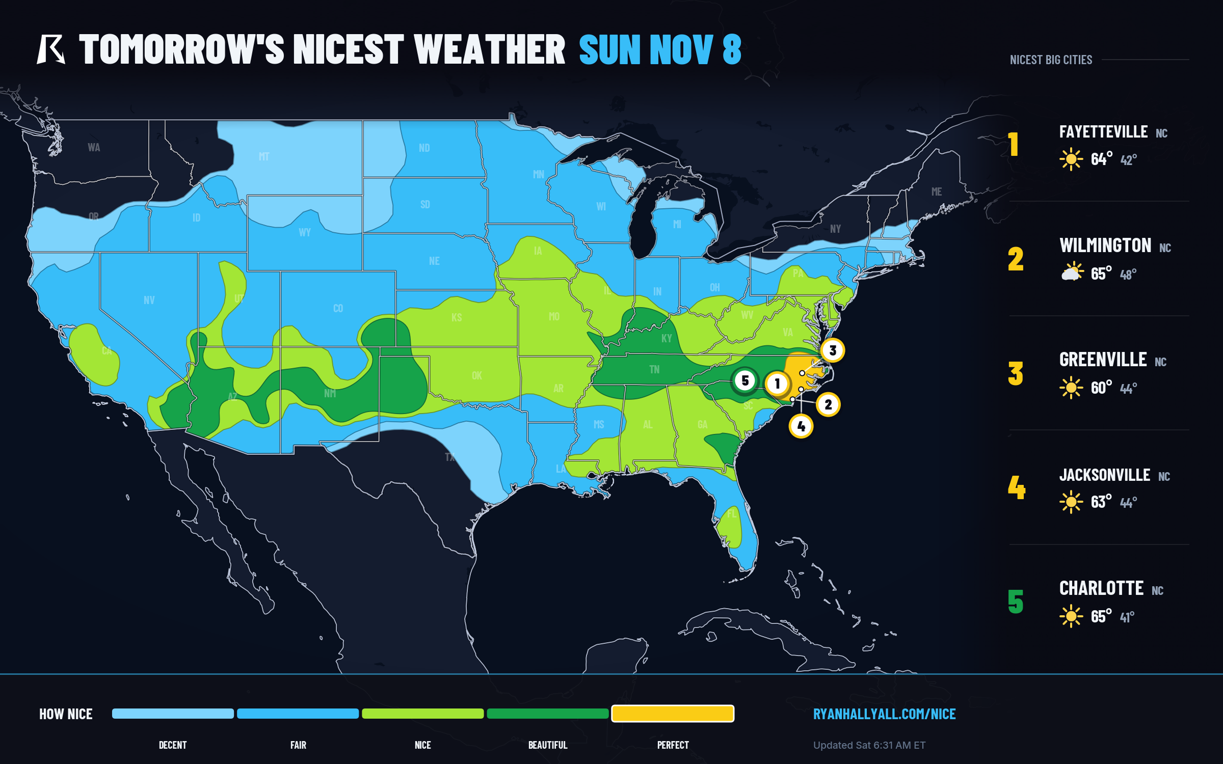
The Carolina Sandhills Are About to Post the Week's Best Weather Score, Right After a Tornado Warning
Y'all, Johnston and Harnett counties, North Carolina, had a rough Friday. Radar-indicated rotation put Bladen, Sampson, and Wayne counties under Tornado Warnings, Wake County picked up a Flash Flood Warning, and a Co-Op observer out toward Norfolk measured 6.33 inches of rain in under a day. That was Friday into Saturday morning.
By Sunday, the exact same general stretch of eastern and central North Carolina is set to score the single best weather of the week anywhere in the country.
That is not a typo, and it is not a coincidence. The front that spun up Friday's storms is the same front that clears the air mass behind it, and once that scrubbed, dry high-pressure dome settles in Sunday, places like Smithfield, Selma, and Magnolia are projected to hit 99.4 out of 100. Wendell, Zebulon, Archer Lodge, Four Oaks, Clayton, Benson, Dunn, and Erwin are all right behind them in the high 99s and low 99s, the best single-day scores any city posts anywhere in the seven-day outlook. Fayetteville itself lands at 99.2, with Wilmington at 92.0 and Jacksonville, NC at 97.9, all landing in the Perfect category. Greenville, NC and a swath of northeastern South Carolina and southeastern Virginia round out the same corridor.
Why This Particular Stripe of the Map
According to the WPC's short-range discussion, a large surface high is settling over the middle of the country this weekend while an upper low over the Great Lakes drags colder air into New England, finishing off the cold rain there by Sunday night. Behind that same system, the airmass draining into the Carolinas is about as scrubbed-clean as it gets this time of year: dewpoints near 45°F, cloud cover around 18 percent, highs in the low-to-mid 60s after a chilly start, and winds light enough that comfort basically caps out on every sub-score except the two that were never going to be limiting anyway (dewpoint and wind, both still excellent). Zero percent chance of rain. Effective AQI in the low 30s. If you are picking a day for a long walk, a football tailgate, or just sitting on a patio with coffee, Sunday in the Sandhills and coastal Carolinas is the pick of the whole map.
It also happens to be the ceiling for a run that has been building for almost a month. Raleigh, Cary, Apex, Garner, Wake Forest, Fuquay-Varina, Holly Springs, Morrisville, and Fayetteville are all sitting on 28-day live streaks of Nice-or-better conditions as of today, matched by Swansea, North, Wagener, Springfield, and Sumter in South Carolina and Savannah, Statesboro, and Pooler in Georgia. Sunday does not break that streak. For a handful of these towns, it is the best single day the streak has produced yet.
The Wider Beautiful Tier
Outside that Perfect core, a broad Beautiful band covers Charlotte, Memphis, Nashville, Albuquerque, Raleigh, and Louisville, all around 82 to 92 on Sunday, with highs in the 60s to low 70s and the same dry, clear setup minus a few degrees or a touch more cloud. Good news if you're not quite in the Sandhills bullseye: you're still looking at one of the better outdoor days of the month.
Today's Quieter Gem
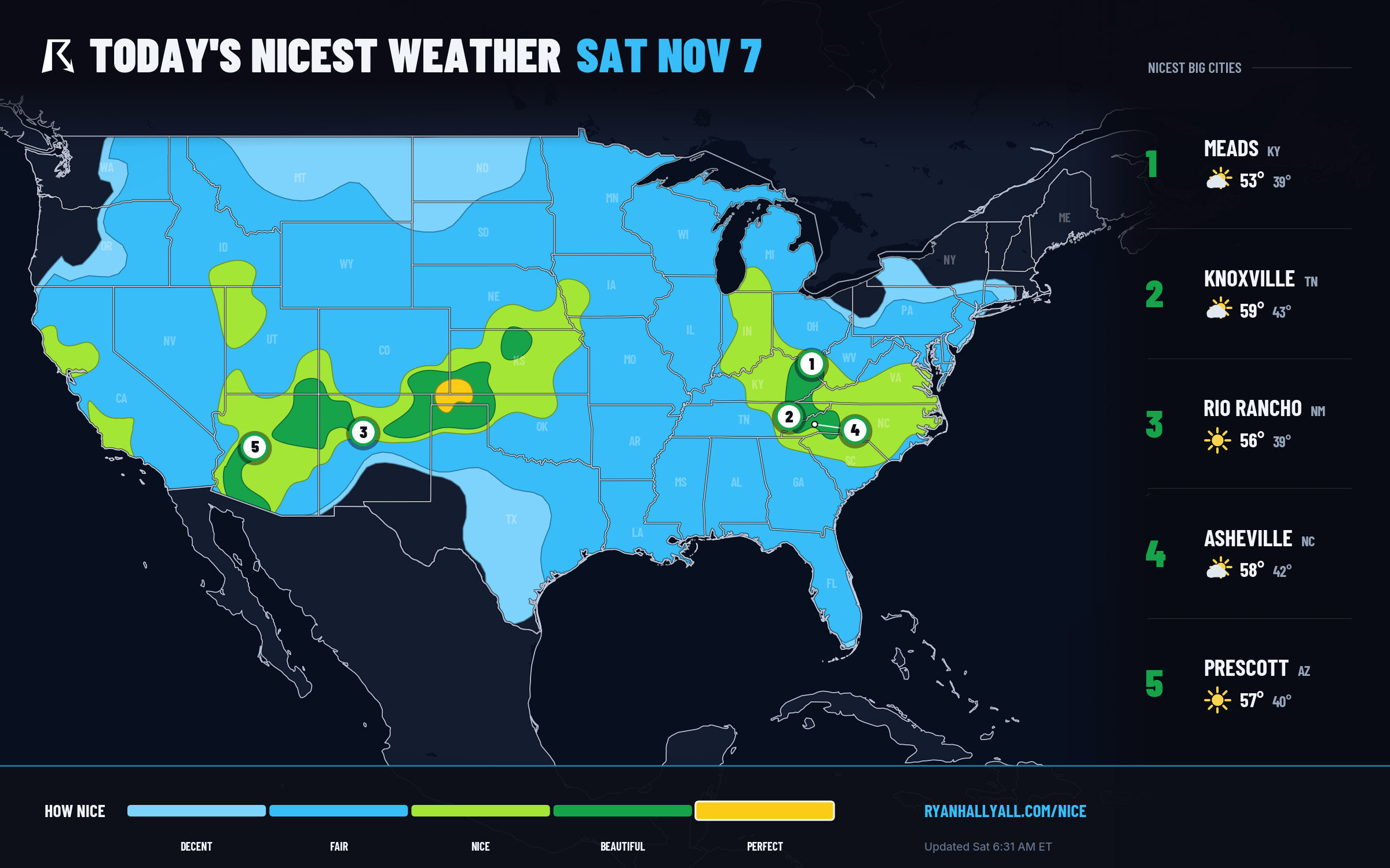
Before Sunday steals the show, today (Saturday) has its own small, scenic bullseye out on the southern High Plains. Canadian, TX; Elkhart, KS; Boise City, OK; and Liberal, KS are all scoring in the mid-to-high 90s under nearly cloudless skies, light 8-9 mph winds, and effective AQI near 30. Highs only reach the upper 50s to low 60s out there, so it is a jacket-then-shirtsleeves kind of day, but the air is about as clean and calm as the outlook gets anywhere this week. Full details and the day's map are on the Nice Weather outlook page.
What to Watch Nearby
Two caveats worth knowing if you're adjusting weekend plans around this stretch. First, overnight lows in the newly-Perfect Carolina corridor dip into the low-to-mid 40s, with some rural spots flirting with frost, so Sunday morning still wants a light jacket before that afternoon warms into the 60s. Second, this same calm pattern has a flip side out in Texas: WPC has already flagged a Slight Risk of excessive rainfall for south-central and southern Texas Sunday into Monday as Gulf moisture surges north into the Hill Country, a separate story worth tracking if your weekend travel runs through Austin, San Antonio, or the Rio Grande Valley.
For everyone east of there, though, Sunday in the Carolinas is about as good as November gets. After a Friday that put some of these same counties under tornado warnings, that's worth sitting outside for.