Blog Article
Severe Weather Outbreak: Hail & Tornadoes Hit Plains Today
An Enhanced Risk of severe weather threatens Oklahoma, Kansas, and Texas today with giant hail and tornadoes. Get the latest forecast and timing details.
No April Fools: Giant Hail and Tornadoes Threaten the Plains Today
Alright y'all, it is April 1st, but I promise there are no jokes in today's forecast. Yesterday we talked about the atmospheric kitchen getting stocked across the Southern Plains. Today, the stove is on and things are about to cook.
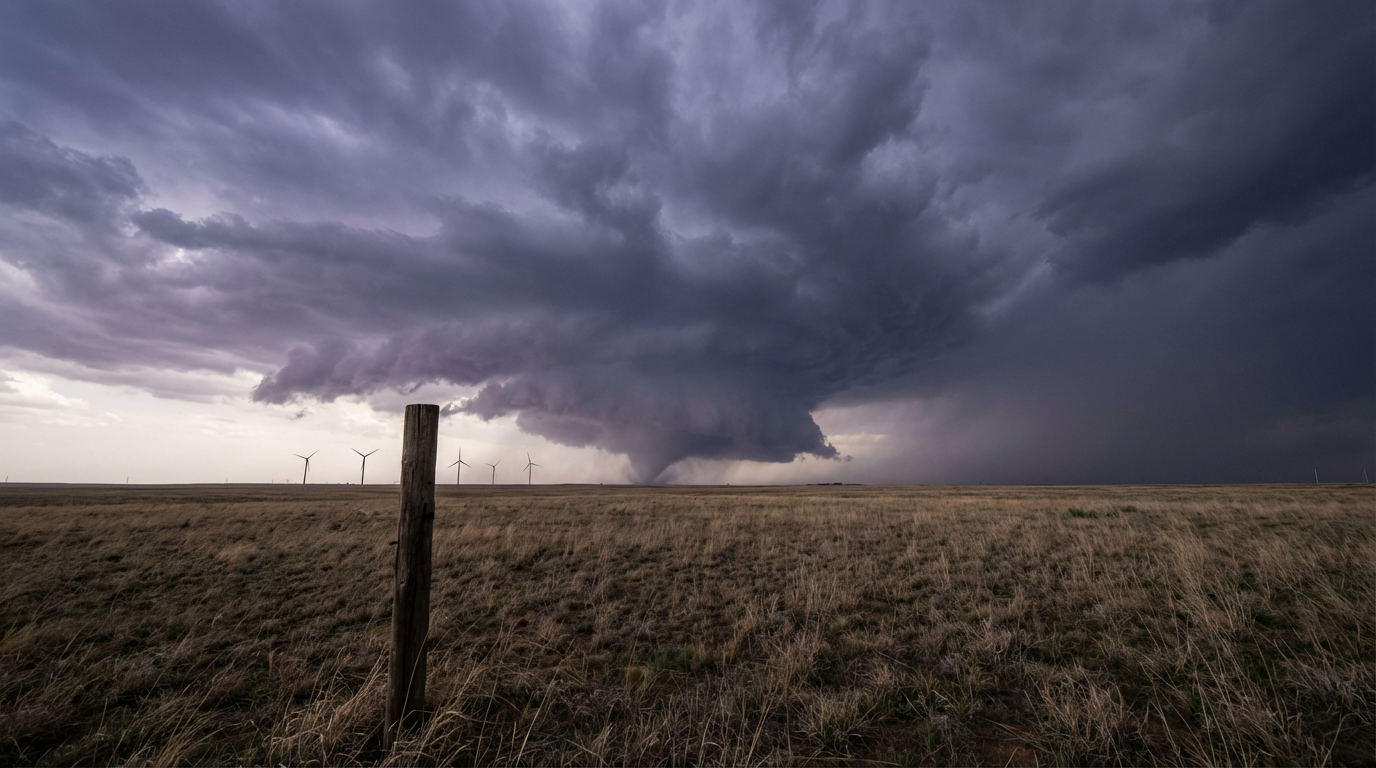
I know a lot of folks are distracted today looking at the Dow futures dropping or reading their April horoscopes, but if you live in the central United States, you need to be looking at the sky. The Storm Prediction Center has an Enhanced Risk out for a big chunk of Oklahoma, Kansas, and northern Texas. If you are in Oklahoma City, Wichita, or Wichita Falls, you need to have your severe weather plan ready to go this afternoon and evening.
The Southern Plains Setup Today
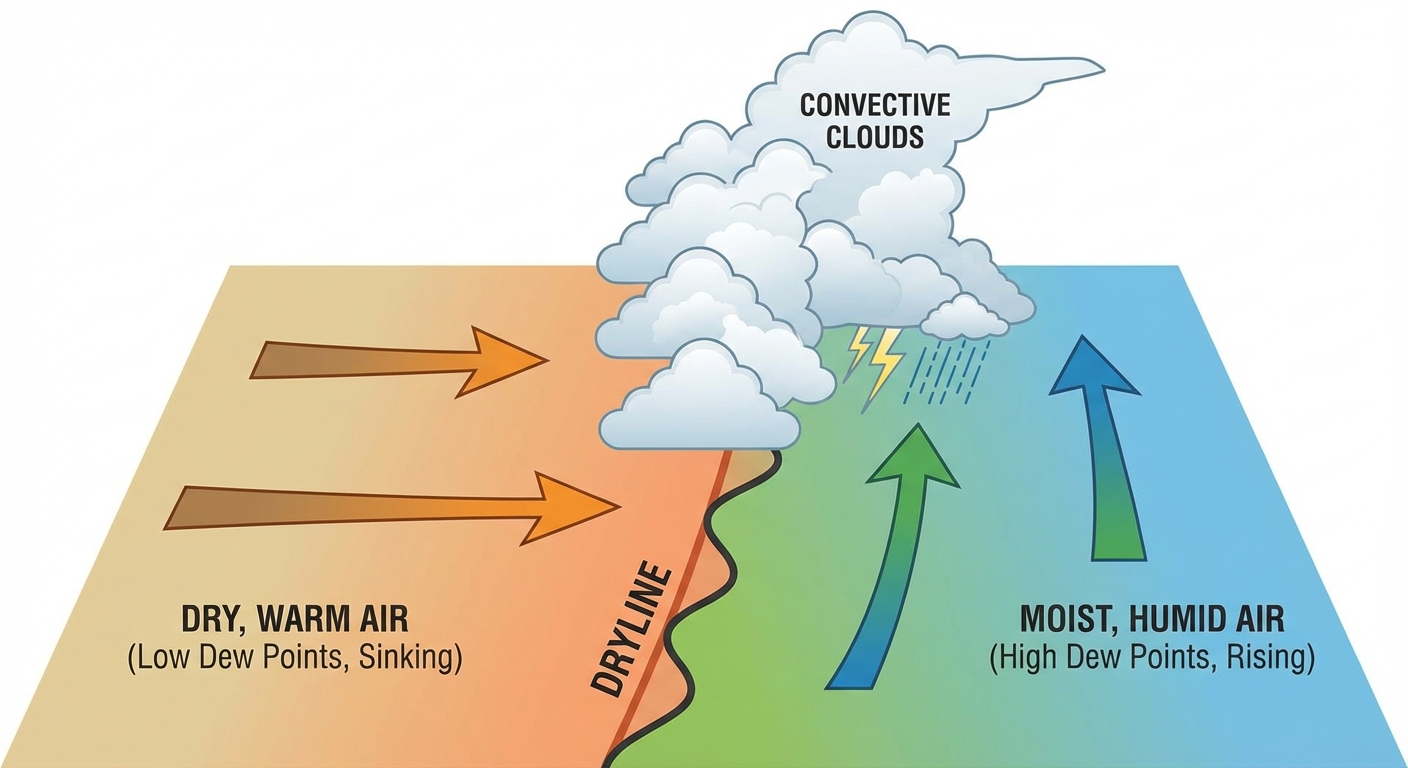
Here is the setup. We have a sharp dryline setting up shop across the Plains. East of that line, we have rich moisture pumping up from the Gulf of Mexico. Normal high temperatures for places like Oklahoma City and Tulsa in early April sit right around 72 degrees. We are going to easily blow past that today, providing plenty of fuel for these storms to tap into.
The main threats today are going to be massive hail and damaging wind gusts. We have a 30 percent probability for both of those hazards. A 5 percent tornado risk is also in play, especially early on when storms are discrete before they merge into a messy line.
Fire on the West, Floods on the East
This storm system is bringing a mixed bag of hazards depending on which side of the boundary you sit. Behind the dryline, the air is bone dry. The SPC has a Critical Fire Weather area highlighted for tomorrow covering the Texas and Oklahoma Panhandles, southeastern Colorado, and southwestern Kansas. Humidity will tank and winds will howl. Please do not burn anything outside if you live in places like Guymon or Dumas.
On the flip side, the Weather Prediction Center has a Slight Risk for excessive rainfall stretching from central Oklahoma right up into northern Missouri today. The ground is going to get a quick one to three inches of rain, so watch out for localized flash flooding on your evening commute.
The Threat Moves East
This system does not stop today. By Thursday, the severe threat shifts into the Midwest and Great Lakes. We have a Slight Risk covering Chicago, Indianapolis, and Milwaukee. If you are traveling through the ORD or MDW airport hubs tomorrow, expect some significant delays as these storms roll through.
Then, get this. A completely separate system drops in for Friday. The SPC already has a Day 3 Enhanced Risk posted for southern Iowa and northern Missouri. Des Moines and Iowa City, you are in the bullseye for that one.
If you are lucky enough to be out west tonight watching the Dodgers or Padres play baseball, you get a pass. The weather out in California is looking absolutely beautiful with high pressure in control.
Bottom Line
- Southern Plains: Have multiple ways to get warnings today. Keep your phone charged, park your car in the garage to avoid the hail, and know exactly where your safe space is.
- High Plains: Avoid any outdoor burning tomorrow due to critical fire weather.
- Midwest: Be ready for severe storms and travel delays on Thursday, and keep an eye on a potent secondary system arriving Friday.
https://ryanhallyall.com/blog/no-april-fools-giant-hail-and-tornadoes-threaten-the-plains-today