Blog Article
Ohio Valley Flood & Severe Storm Risk Today, Aug 11
Enhanced severe storms and a Moderate flood risk hit the Ohio Valley today. Get the timeline, hazards, and tropical update in plain Southern English.

Ohio Valley in the Crosshairs Again: Moderate Flood Risk Meets Enhanced Severe Storms Today
Alright y'all, if you felt like yesterday never really ended, that's because it kind of didn't. After Sunday's outbreak dropped an EF-1 tornado near Streator, Illinois, an 84 mph gust in Goodyear, Arizona, and a destructive-tagged severe thunderstorm warning on Prince George's County, Maryland, the atmosphere is still not done with the Ohio Valley. Today's the day two hazards stack right on top of each other there: severe thunderstorms AND flash flooding.
The Big Story: Enhanced Severe Risk Meets Moderate Flood Risk
SPC has an Enhanced Risk posted from northern Illinois through the Ohio Valley, covering Chicago, Columbus, Indianapolis, Lexington, and Cincinnati. That's roughly 20.9 million people under the highest category on today's map. A Slight Risk wraps around that core, and a Marginal Risk stretches all the way out to Philadelphia, Charlotte, and DC.
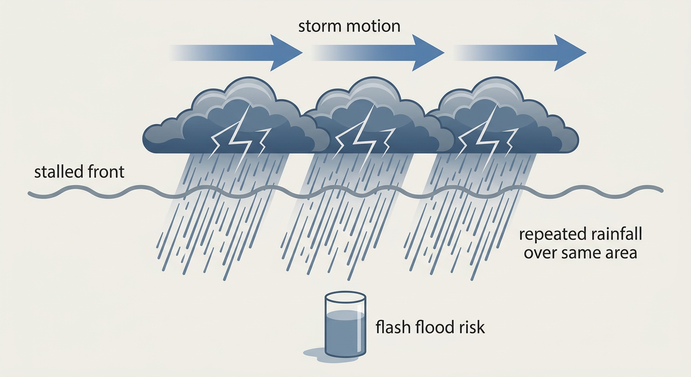
Here's the thing that makes today different from a garden-variety severe day: WPC has also placed a Moderate Risk of excessive rainfall over parts of the Ohio Valley, the highest rainfall category WPC issues. That's not a coincidence. The same quasi-stationary front and low-level jet that's firing the storms is also going to let them repeat over the same neighborhoods, a process meteorologists call training. Indianapolis is looking at MUCAPE in the 4,000 to 5,000 J/kg range with 40+ knot deep-layer shear, and WPC guidance shows local 3 to 5 inch rainfall totals possible on top of the wind and hail threat. Charleston, West Virginia's forecast office was specifically named in the WPC coordination for southwestern West Virginia, where complex Appalachian terrain and already-primed soils raise the flash flood odds even more, with some model output showing 6 to 8 inch local maxima.
What's Driving It, In Plain Terms
Think of it like a conveyor belt that got stuck on one setting. The jet stream's equatorward edge is parked from the Northern Plains into the Ohio Valley and Mid-Atlantic, and that boundary isn't going anywhere fast. Low-level confluence and an instability gradient are focusing storm development right along it, day after day. That's the same basic setup that's been running since the start of the month, honestly. This has been a stuck pattern.
For today's severe threat specifically:
- Wind is the headline hazard. SPC has a 30% (Level 3, numerous damaging wind threat) probability area, with a hatched zone inside it where gusts could reach 75 mph or more. That's about 27.5 million people inside that hatched significant-wind area.
- Hail is secondary but not zero. A 15% (Level 2) hail probability area exists with a hatched zone for 2 inch, hen-egg-size hail possible.
- Tornadoes are a lower-end concern. Only a 2% isolated tornado probability today, so this is fundamentally a wind and flash-flood day, not a tornado day.
Timeline: Where This Goes Next
- Today (Tuesday): Enhanced Risk, northern Illinois into the Ohio Valley and central Appalachians. Moderate flood risk, same general footprint.
- Wednesday (Day 2): The severe focus splits and shifts west. SPC has a new Slight Risk over the central and northern High Plains, eastern Colorado, western Nebraska, and northern Kansas, where a surface low and steep lapse rates should support discrete, large-hail-producing storms that may grow into an evening MCS with damaging winds toward Nebraska and the Missouri Valley. A secondary Slight Risk lingers over the Midwest and Ohio Valley too, with the flood risk downgraded to Slight there.
- Thursday (Day 3): A Marginal severe risk persists from the central High Plains into the Ohio Valley, with the flood concern easing to Slight and expanding into the High Plains and Southwest.
That Southwest mention matters. Tucson is dealing with its own multi-day flash flood setup tied to the monsoon, with WPC Slight Risk posted for Days 1 through 3 along the I-19 corridor and HREF probabilities of 60 to 90% for more than an inch of rain. Burn scars around the Huachuca Mountains raise the stakes there, and yeah, that's part of why Phoenix weather is trending nationally this morning. Storms could reach the Phoenix area again tonight after last night's monsoon punch, though the more serious flash flood signal sits closer to Tucson.
Tropical Watch: Something Brewing Far Offshore
NHC is tracking three disturbances in the Atlantic this morning. The one to note is a low pressure area about 500 miles southwest of the Cabo Verde Islands, which carries a High risk designation, 30% chance of development in the next two days and 70% through seven days. NHC expects a tropical depression to likely form later this week as the system moves west. It's a long way from the U.S. right now and there's no coastal threat to discuss yet, but with the deep tropics starting to wake up in mid-August, it's worth keeping half an eye on. The other two Atlantic areas are Low risk, and Invest 93CP sitting way out in the central Pacific near 141°W is weak, 25 knots, and not a U.S. concern.
How This Touches Your Week
Baseball fans in Chicago and DC should keep an eye on radar this afternoon and evening. The Cubs host the Nationals in DC and the Reds are in Chicago against the White Sox, both cities sitting inside today's Enhanced Risk. Guardians-Tigers in Detroit is close enough to the northern edge of the Slight Risk to watch too. If you've got the Illinois or Iowa State Fair on your calendar starting Thursday, or you're headed to Indianapolis, Louisville, or Cincinnati for anything outdoors this week, build in a backup plan. The pattern isn't going to fully clear out before the weekend NFL preseason slate kicks off in Cincinnati and Pittsburgh on Thursday, though severe coverage there should be lower than what Chicago and Indianapolis are dealing with today.
What We're Watching
- Training thunderstorm cells and flash flood warnings across the Ohio Valley through tonight
- The 75+ mph hatched wind zone in Illinois, Indiana, and Ohio
- West Virginia's Appalachian terrain amplifying flood impacts on already-saturated ground
- Wednesday's High Plains severe threat in eastern Colorado and western Nebraska
- Tucson's ongoing monsoon flash flood risk through Thursday
- The Cabo Verde disturbance's development chances as the week goes on
Bottom Line
If you live anywhere from Chicago to Cincinnati to Charleston, West Virginia, today calls for a real plan, not just an umbrella. Know how you'll get flash flood warnings, avoid low water crossings tonight, and don't be surprised if the sky turns loud with little tornado risk but plenty of wind and rain. Everybody east of there through DC and Charlotte is in a lower-end Marginal zone, so stay weather aware but don't panic. Out west, Tucson residents should treat this like day three of an ongoing monsoon flood pattern, not a one-off storm. And for the rest of the country, this is a good week to just keep tabs on the tropics. Nothing's imminent, but the Atlantic is stirring.