Blog Article
Severe Storm Risk Today: Ozarks to Southern Plains, Aug 6
SPC posts a Slight Risk for the Ozarks and southern Plains today, with a Marginal risk stretching to DC and Baltimore still drying out from flooding.

Ozarks to the Southern Plains Get a Slight Risk Today, While the Mid-Atlantic Tries to Dry Out
Alright y'all, let's talk about today. The Storm Prediction Center has a Slight Risk posted for parts of southeast Kansas, northeast Oklahoma, southwest Missouri, and far northwest Arkansas. Springfield, Joplin, Rogers, Chanute, and Coffeyville are the named cities, and that's about 1.7 million people sitting under the higher-end risk today.
A broader Marginal Risk wraps around that Slight area and stretches all the way to the Mid-Atlantic, covering roughly 25.8 million people from Wichita and Tulsa over to Washington DC and Baltimore, with a piece up into Syracuse, NY too.
What's actually going to happen
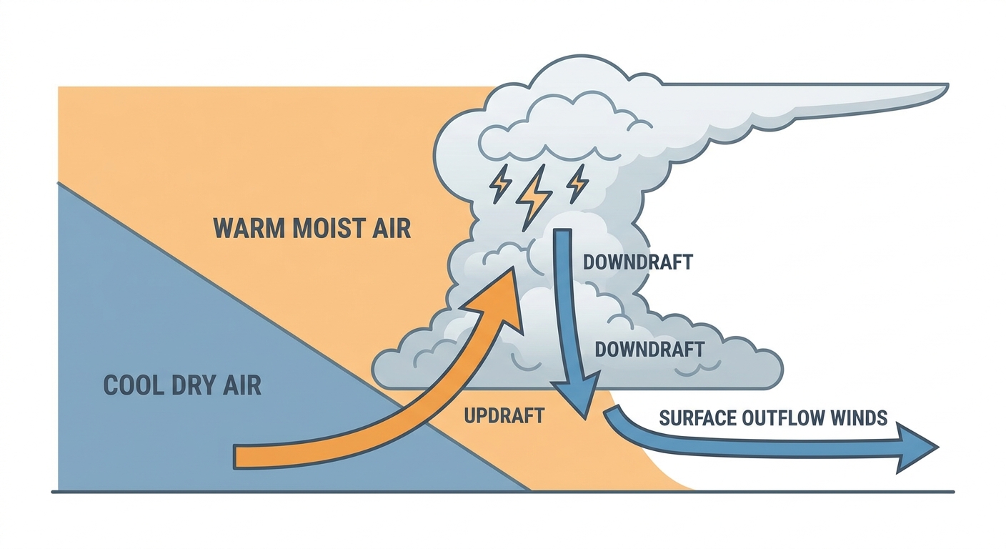
An upper-level disturbance is sliding across the Plains and Ozarks today, and it's going to fire up thunderstorms along a boundary this afternoon and evening. SPC's numbers put a 15% (Level 2) chance of scattered damaging wind gusts inside that Slight zone, and there's a hatched area tucked inside it where gusts could reach 75 mph or better if a storm really gets going. Hail up to quarter-size is also on the table, though that risk is lower, just a 5% isolated chance.
So here's the practical read: if you're in Springfield, Joplin, or anywhere along that Ozark corridor this afternoon, keep half an eye on the sky. These won't be widespread, but the ones that do go severe could do it in a hurry with strong outflow winds.
Farther east, the Marginal risk over DC and Baltimore is a lower-end concern, mostly some gusty storms possible as they move off the Appalachians into the lowlands. But there's context here that matters. This same corridor got hammered yesterday. Philadelphia, Baltimore, and the DC suburbs saw flash flooding that stranded cars on I-95, the PA Turnpike, and the New Jersey Turnpike. The ground is still saturated in a lot of these spots, so even a modest storm today can produce runoff faster than it normally would.
The rain threat isn't done either
WPC has a Marginal excessive rainfall risk posted today stretching from the Southwest through the Central and Southern Plains, into the Midwest, and over toward the East Coast. The setup is a southward-moving cold front pulling in increasingly moist, southerly flow overnight. WPC's discussion points to localized totals around 2.5 inches in spots, mainly over the Lower Missouri Valley and Lower Lakes/Ohio Valley. That's not a flood emergency type of setup like Virginia saw a couple days back when Chesterfield County measured 7.30 inches, but it's enough to cause some ponding on roads that are already primed to flood after this week's rain.
Tomorrow's shift: north and east
By Friday, the severe risk slides into the Upper Mississippi Valley and Northeast. SPC's Day 2 outlook has a Marginal risk over Iowa, southeast Minnesota, Wisconsin, and Upper Michigan, plus another Marginal area from northern Virginia into Pennsylvania and southern New York. That's Philadelphia, DC, Baltimore, Minneapolis, and Des Moines all under some risk of gusty storms tomorrow afternoon. If you're headed to WE Fest in Detroit Lakes, MN, or catching the Wisconsin State Fair crowd carrying into Friday, keep tabs on the afternoon sky.
Saturday, the focus narrows to a corridor from Nebraska into Iowa and northern Missouri, where a Marginal risk for damaging wind sits over Omaha and Des Moines.
Fire weather and smoke out West
While the East deals with rain and storms, the Interior West stays locked in a dry pattern. SPC's fire weather discussion notes a very dry fuelscape persisting under upper-level ridging, and numerous large wildfires across the Pacific Northwest and northern Rockies are still pumping smoke into the upper flow, which is why that smoke keeps showing up as far away as the Midwest in our air quality numbers. If you're in that region, this is nothing new, just a continuation of a pattern that's been running for days.
A quick space weather note
Geomagnetic conditions are quiet right now, but SWPC is watching for a possible G1 (Minor) storm late Friday into Saturday as CMEs that left the Sun on August 3rd arrive. Nothing that affects your day-to-day, but aurora chasers up north might want to check back Friday night.
What we're watching
- Ozark/Southern Plains storms this afternoon: isolated 75 mph gust potential inside the hatched zone
- Already-saturated ground from DC to Baltimore ahead of today's Marginal-risk storms
- Locally heavy rain (up to 2.5 inches) along the Lower Missouri Valley and Lower Lakes tonight
- Friday's severe risk sliding into Iowa, Wisconsin, and the I-95 Northeast corridor
- Continued smoke transport from Pacific Northwest wildfires affecting air quality well downstream
Bottom line
If you're in the Ozarks or southern Plains today, have a way to get warnings this afternoon and evening, the strongest storms could bring damaging gusts. If you're anywhere from Tulsa to Baltimore, it's a lower-end day, but don't ignore standing water on roads that flooded just yesterday. And if your weekend plans take you into Iowa, Wisconsin, or the Philadelphia to New York corridor, keep an eye on Friday's forecast because the risk simply moves with you.