Blog Article
US Weather Forecast: Phoenix Heat, Fire Risk & PNW Rain
Track the earliest 100-degree day in Phoenix, critical fire weather in Texas and Oklahoma, and a multi-day atmospheric river soaking the Pacific Northwest.

The Day After the Blizzard: Phoenix is Baking and the Pacific Northwest is Soaking
Alright folks, let's take a collective deep breath. The last 24 hours have been absolutely wild. Yesterday, we watched a historic blizzard drop an unbelievable 35 inches of snow in Michigan, while a massive line of severe storms knocked out power for hundreds of thousands on the East Coast. The dust is finally settling from that system.
But here is the thing about the weather. It never actually sleeps. Today is Tuesday, March 17, 2026. Happy St. Patrick's Day to those celebrating! Let's dive right into what we are tracking today because the map is still incredibly busy.
The Southwest Oven and Critical Fire Danger
As we talked about yesterday, the Southwest is literally turning into Arrakis. Get this. Phoenix is forecast to hit 100 degrees today. If that happens, it will officially be the earliest 100-degree day in the city's recorded history, beating the old record by over a week. Extreme Heat Warnings have expanded across the Arizona and California deserts.
If you are heading out to the MLB Spring Training games today, like the White Sox playing the Rangers in Surprise or the Cubs taking on the Guardians in Goodyear, you have to take this heat seriously. Drink plenty of water and find some shade. It is going to be a scorcher.
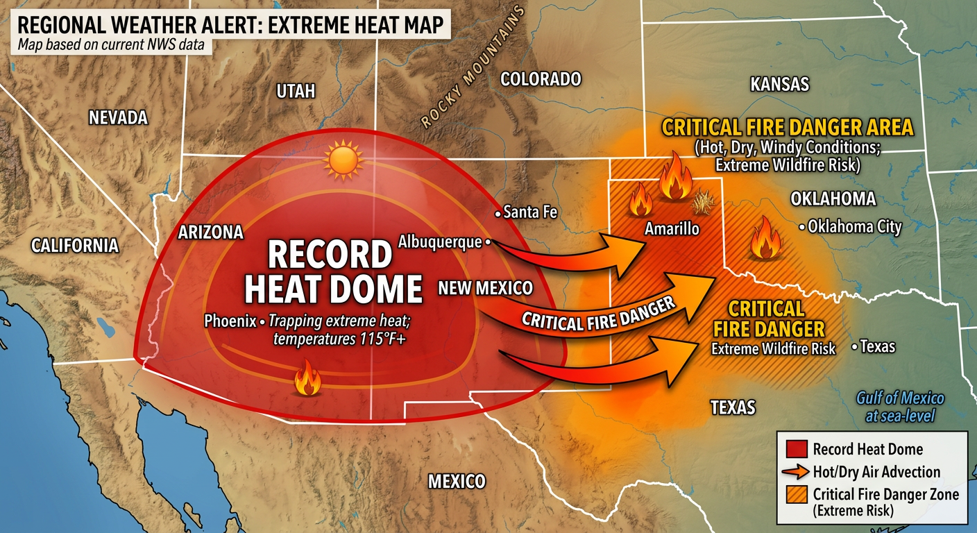
All that dry, hot air is getting pushed eastward, and that is creating a massive headache for the Southern Plains. The Storm Prediction Center has issued a Critical Fire Weather risk for Northwest Texas right up into Southwest Oklahoma today. Cities like Altus, Oklahoma, and Vernon, Texas, are right in the bullseye. We have dewpoints dropping into the single digits and very strong winds. If a spark catches in these dry fuels, it will spread incredibly fast. Please do not do any outdoor burning today.
The Pacific Northwest Firehose
While the Southwest bakes, the Pacific Northwest is dealing with the exact opposite problem. A relentless atmospheric river is pointing a firehose of moisture right at Washington State.
The Weather Prediction Center has outlined a Marginal Risk for excessive rainfall today, tomorrow, and Thursday. We are looking at a multi-day soaking that could drop 4 to 9 inches of cumulative rainfall over the Northern Cascades and the Olympic Peninsula.
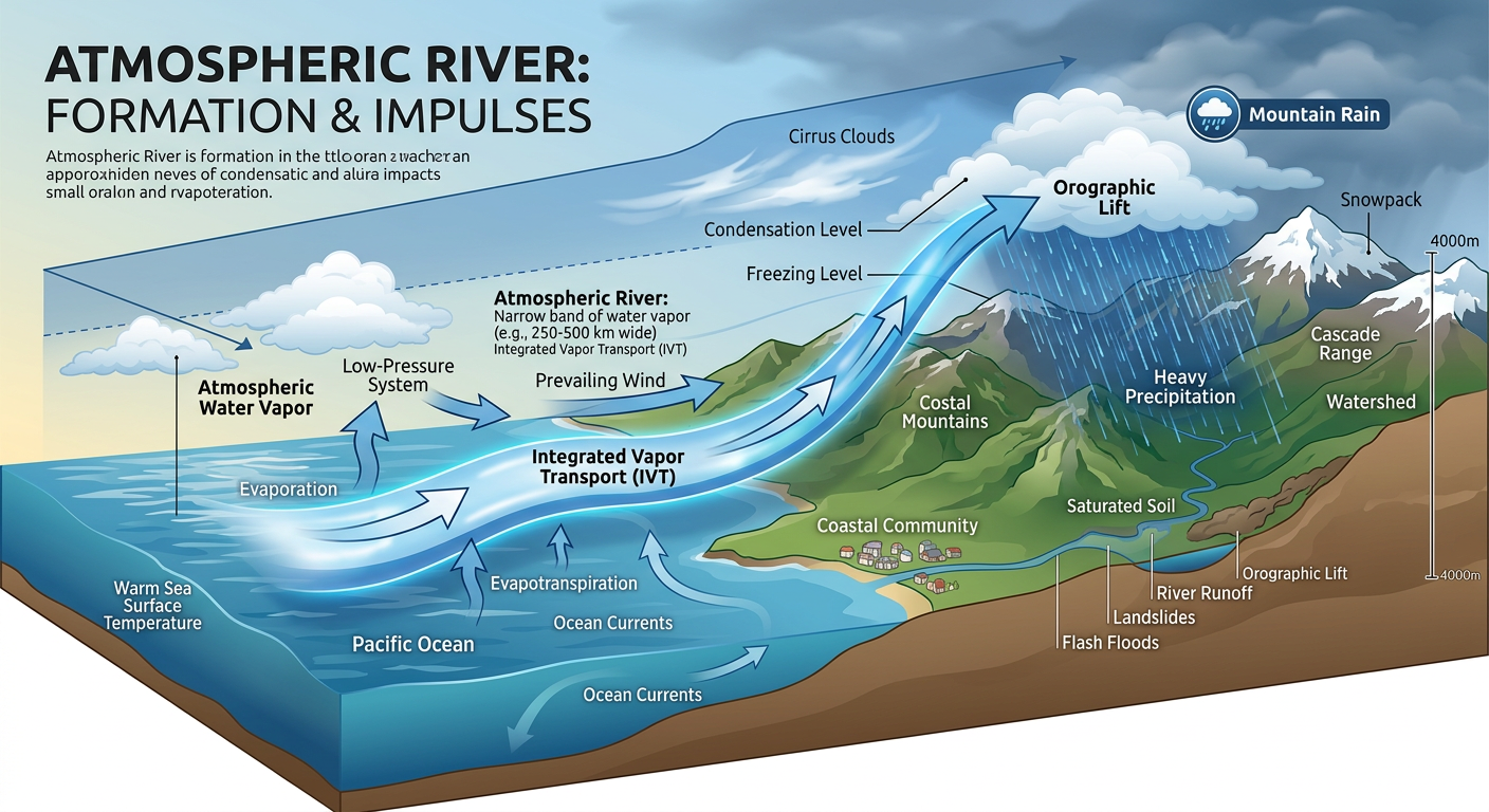
Here is how this impacts your daily life. If you are commuting around Seattle or western Washington, expect incredibly slow travel and ponding on the roadways. More importantly, we are closely watching the river levels. The Skokomish and Chehalis rivers are at high risk for flooding as all this rain combines with melting mountain snow. If you live in a flood-prone area, now is the time to be prepared.
A Quick Northern Clipper
Finally, we have a fast-moving clipper system sliding across the Northern Plains and Upper Midwest. For folks in Wisconsin and Michigan who are still trying to dig out from yesterday's massive blizzard, you are going to see another 1 to 2 inches of light snow.
But the bigger concern is actually slightly west. Over in North Dakota and Minnesota, local forecast offices are warning about a risk for freezing drizzle on the backside of this system. That is the kind of weather that turns your morning commute into an ice rink. Leave early and take it slow on those untreated overpasses.
Key Things We Are Watching
- Phoenix Heat Record: Monitoring to see if Phoenix officially hits that 100-degree mark today for the earliest time in history.
- Southern Plains Fire Risk: Critical fire weather conditions today for NW Texas and SW Oklahoma. High winds and single-digit dewpoints mean extreme caution is needed.
- Washington Flooding: A multi-day atmospheric river will bring heavy rain and potential river flooding to the Pacific Northwest through Friday.
- Upper Midwest Ice: Watch out for sneaky freezing drizzle in North Dakota and Minnesota today as a clipper system moves through.
The Bottom Line
We are swinging from one extreme to another today. If you are in the Southwest, keep the AC running and stay out of the midday sun. If you are in Texas or Oklahoma, hold off on any outdoor burning and secure trailer chains so they do not spark on the highway. Up in Washington, keep your rain gear handy and watch those river levels. And for my friends in the Upper Midwest, do not let that freezing drizzle catch you off guard on the roads.
Stay safe, stay weather aware, and I will see y'all in the next update!