Blog Article
Plains Hail Threat and Building Heat Wave: June 28 Forecast
Severe storms with large hail target the Dakotas and Upper Midwest Sunday into Monday as a dangerous heat wave builds across the central and eastern U.S.
Plains Heat and Hail: Where the Storm Threat Sets Up Next
Alright y'all, let's catch our breath for a second. The last week has been relentless. We watched catastrophic flash flooding tear through central Kentucky and southern Indiana on Friday, with rainfall totals up to 10 inches and at least four lives lost. That came on the heels of a Wichita flash flood emergency and 100-plus mph wind gusts out on the High Plains. June 2026 has been one of the busiest stretches of weather we've seen in a long while.
So here's where things stand this Sunday morning, June 28. The big rain-maker that flooded the Ohio Valley is winding down. The severe weather torch is getting handed off to the northern Plains and Upper Midwest. And there's a heat wave quietly building in the background that's gonna be the bigger story for most folks east of the Rockies by midweek.
Let me walk you through it.
Today's storm threat: the Dakotas and northern Iowa
The Storm Prediction Center has a Slight Risk (that's Level 2 out of 5) posted across the Dakotas, northwest Minnesota, and northern Iowa for today into tonight. A broader Marginal Risk (Level 1) wraps in places like Minneapolis, Milwaukee, Madison, and even stretches east toward Charlotte and Raleigh.
Here's the thing about this setup. The main cyclone is occluding way up near the Saskatchewan and Alberta border, and a belt of south-southwesterly winds aloft is riding over the northern Plains. That's the engine. Storms fire across northern Iowa this afternoon, then the action shifts mainly to the Dakotas tonight.
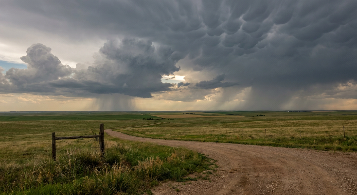
The headline hazards are large hail and damaging wind. The SPC has a 15 percent hail and wind threat over the slight-risk zone, and there's a small hatched area where stones could reach 2 inches, hen-egg size. That's the kind of hail that dents hoods and cracks windshields.
If you remember the data from earlier this week, the northern Plains have already been a hail and wind factory. We had a 70 mph gust at the Williston, North Dakota airport Saturday night and a brief tornado reported north of Belfield. This is the same general neighborhood staying active.
Monday: focus tightens on the Upper Midwest
Monday's Slight Risk covers roughly 164,000 square miles from the Dakotas into northern Minnesota and the Upper Midwest, including Minneapolis, Sioux Falls, Fargo, and Duluth. About 7 million people are inside that zone.
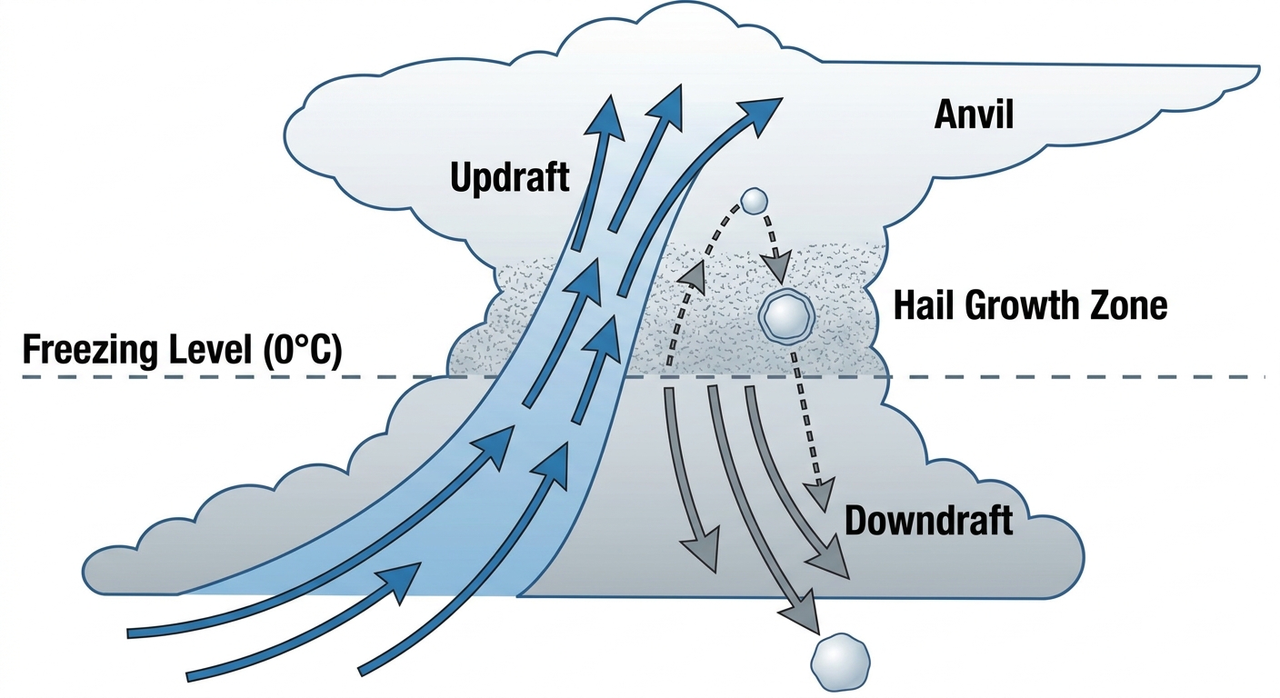
The ingredients are there for serious storms. Forecast soundings show extreme instability, more than 4,000 J/kg of CAPE, and 50-plus knots of effective shear. In plain English: lots of fuel and lots of spin available. Large to very large hail and severe winds are the primary concerns, and there's a low-end tornado threat near the surface low in eastern North Dakota and northwest Minnesota, where the SPC has a 5 percent tornado area.
But here's the honest part. There's real uncertainty about whether storms even get going. A building upper ridge is putting a cap on the atmosphere, basically a warm lid that can keep storms from initiating even when the fuel is loaded. If the cap breaks, the storms that form could be intense. If it holds, much of this stays quiet. That's a coin-flip kind of forecast detail, and your local National Weather Service office will sharpen it up through the day.
The Twins are home against the Rockies this afternoon at 1:10 local. Sunday's threat is mostly to the north and west of the Twin Cities, so the ballgame should be fine, but Monday is worth keeping an eye on if you've got outdoor plans up that way.
The bigger story: a heat wave is loading up
While everybody watches the storms, the pattern that's really gonna shape the week is heat. That same upper ridge capping the Plains is also going to broaden and settle over the central and eastern U.S. Heat indices are forecast to climb into the 105 to 110 degree range across a big chunk of the country, with a Major to Extreme HeatRisk in spots.
For context, normal late-June highs run around 88 in Oklahoma City and Tulsa, 87 in Charlotte and Raleigh, and 79 in Minneapolis and Detroit. When you start stacking heat index values north of 105, that's dangerous territory, especially with humidity dragging dewpoints into the low to mid 70s. That combination doesn't let your body cool off, even at night.
There's a lot of outdoor activity riding into this. Summerfest cranks up another weekend in Milwaukee, the Peachtree Road Race runs in Atlanta on the Fourth, and there's a full slate of ballgames across the heat zone. If you're headed to any of it, treat the heat like the hazard it is: water, shade, and breaks.
Quieter corners and the rest of the map
It's not all rough out there. The Upper Great Lakes into interior New England get a genuinely beautiful Sunday, with low humidity and light winds under high pressure. Coastal California and northern New England look great Monday. The West Coast and Intermountain West stay the pleasant exception through the week while the heat owns the middle of the country.
One corner that stays stubborn: the Four Corners. Critical fire weather is hanging on for a fourth straight day across northern Arizona, southeastern Utah, western Colorado, and northwestern New Mexico. We're talking 15 to 20 mph winds, relative humidity down to 10 to 15 percent, and energy release components running in the 80th to 95th-plus percentiles. The Cottonwood Fire near Beaver, Utah grew to about 72,000 acres earlier this week, and these conditions don't help crews get ahead of anything.
In the tropics
Nothing urgent, but worth a note. The National Hurricane Center is watching a broad area of low pressure expected to form offshore of the Southeast coast in a couple of days. Formation odds are low, near 0 percent through 48 hours and 20 percent over seven days. We saw Tropical Storm Arthur earlier this month, so the Atlantic is awake, but this one is a slow-burn watch item, not a threat right now.
What I'm watching
- Will the cap break Monday in the Upper Midwest? If it does, expect big hail and the chance of a strong storm. If it holds, much of the region stays dry.
- Tonight's storms in the Dakotas. Large hail and damaging wind are the main concerns, with that hatched 2-inch hail area in play.
- The heat wave ramping up midweek across the central and eastern U.S., with heat indices toward 105 to 110.
- Four Corners fire weather, day four and counting, with the Cottonwood Fire already large.
Bottom line
If you're in the Dakotas, northern Minnesota, or northern Iowa, today and tonight are your storm days. Watch for large hail and gusty winds, and have a way to get warnings if you're camping or out late. Folks in the Upper Midwest, keep half an eye on Monday, knowing the forecast could swing depending on that cap. And just about everyone in the central and eastern U.S. should start planning for real heat by midweek. Drink more water than you think you need, check on older neighbors, and don't leave anyone in a parked car. That heat is the threat that'll touch the most people this week.
https://ryanhallyall.com/blog/plains-heat-and-hail-where-the-storm-threat-sets-up-next