Blog Article
February 28, 2026 Weather Recap: Historic 173-Degree Split
A complete recap of the February 28, 2026 weather events, featuring a historic 173-degree temperature split, Midwest snow, and Florida severe storms.

The Day The U.S. Split in Half
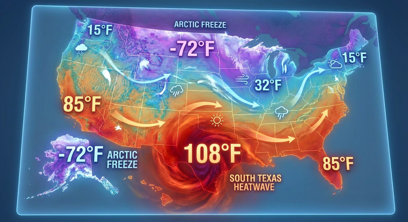
Alright folks, gather around. If you stepped outside yesterday, February 28, 2026, you either needed a heavy parka or a bathing suit. Get this. We saw a historic 173-degree temperature spread across the country. That is just absolutely wild. Let us talk about exactly what happened, what caught us off guard, and what is coming next.
The biggest headline by far was the absolute extreme temperature dipole we witnessed. Down in Laredo, Texas, the mercury soared to 103°F. That was not only the very first time the U.S. saw triple digits in 2026, but it also shattered an all-time February record. Meanwhile, way up on the Alaska Beaufort Sea Coast, folks were dealing with life-threatening wind chills of -70°F and pure blizzard conditions. Kaktovik recorded wind gusts up to 65 mph. You just do not see a 173-degree national temperature spread every day.
The Midwest Clipper and Florida Storms
While Texas was baking and Alaska was freezing, the Upper Midwest got hit with a classic Alberta Clipper. We expected snow, but the 20 to 1 snow-to-liquid ratios made it pile up incredibly fast. Minneapolis, Milwaukee, and Detroit saw heavy snowfall rates of an inch per hour. We got ground truth reports of exactly 10 inches of snow in Lanesboro, Minnesota.
Down south, Florida got rowdy. We had severe thunderstorm warnings firing off in Palm Beach, St. Lucie, and Martin counties. A storm packing 60 mph wind gusts and 1.5-inch hail actually tracked right over the St. Lucie Nuclear Power Plant. Later in the evening, the Central Plains saw some action too. We had confirmed hail reports up to 1.25 inches near Tryon, Oklahoma, and 1-inch hail in Drumright, Oklahoma.
Out west, a major Pacific storm system made landfall. Northern California and the Pacific Northwest got soaked, and the mountains got slammed with that heavy "Sierra Cement" snow we all know so well.
Forecast vs. Reality: What We Learned
Here is the thing about yesterday. The weather models had a fantastic handle on the extreme temperatures, but the intensity of the Midwest snow bands over-performed in some localized spots. Those frontogenetical snow bands are notoriously tricky for meteorologists to pin down, and they delivered aggressive snowfall rates exactly where they set up. The Florida severe storms transitioned from a land threat to a maritime threat pretty seamlessly, which was thankfully right in line with our expectations.
What Is Coming Next
We are not done yet, y'all. The storm energy is shifting east, and things are about to get messy.
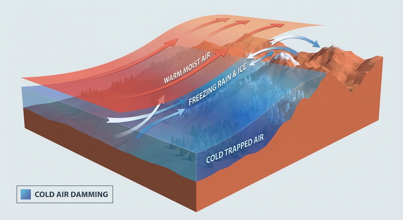
We are looking at a classic Cold Air Damming situation developing in the Central Appalachians and Mid-Atlantic. Sub-freezing air is getting trapped east of the mountains, and that means we are expecting dangerous ice accumulations of 0.10 to 0.20 inches in Western Maryland and Central Pennsylvania. If you are commuting in the Ohio Valley on Monday morning, expect a messy, slippery wintry mix.
Meanwhile, out west, the Rockies in Wyoming and Colorado are gearing up for 6 to 12 inches of heavy mountain snow as a potent shortwave moves through.
The Bottom Line
- Yesterday was a day of historic extremes, featuring a 173-degree temperature difference between Alaska and Texas.
- The Midwest took a solid punch from an Alberta Clipper, dropping up to 10 inches of fluffy snow in Minnesota.
- Severe storms brought 60 mph winds and large hail to South Florida and Oklahoma.
- The next big threat is freezing rain and ice for the Mid-Atlantic and heavy snow for the Rockies.
Stay weather aware, check your local forecasts, and please be extremely careful on the roads Monday morning if you live in the Ohio Valley or Mid-Atlantic. Keep it safe out there, y'all.