Blog Article
March 05, 2026 Weather Recap: Tornadoes & Flooding
A complete recap of the March 05, 2026 severe weather outbreak, including the Nash OK PDS tornado, DFW flash flooding, and Northeast ice storm impacts.

The March 05, 2026 Outbreak: From Floods to a Nighttime Tornado
Alright folks, let's talk about what just happened. Y'all know that spring weather transitions can be wild, but yesterday was a textbook example of how quickly the atmosphere can flip the script. We started March 5, 2026, dealing with life-threatening water rescues, and we ended it watching a Particularly Dangerous Situation (PDS) tornado tear through the dark in Oklahoma.
Here is the thing about yesterday. It was a multi-state, multi-hazard mess. Let's break down exactly how the day unfolded.
How the Day Unfolded
The morning hours were entirely dominated by water. We saw a widespread hydrological emergency set up across the Ohio and Mid-Mississippi Valleys. Training thunderstorms dumped 3 to 5.75 inches of rain across central Indiana and Butler County, Ohio. Down south, the Dallas-Fort Worth metroplex saw life-threatening flash flooding that required active swiftwater rescues.
While the middle of the country was underwater, the Northeast was dealing with a significant winter event. Ice accretion hit 0.30 inches in parts of New York, which led to multi-vehicle accidents. Get this, one of those accidents involved a tractor-trailer hauling 20,000 pounds of mail.
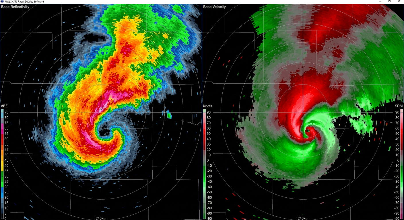
Then came the evening. As the flooding threat stabilized, the atmosphere out west was getting primed. Discrete supercells fired up along a dryline in the Texas Panhandle and Oklahoma. By late evening, this culminated in a massive, confirmed PDS tornado near Nash, Oklahoma. The radar data showed rotational velocities up to 79 knots, and a clear debris signature confirmed it was doing damage on the ground.
Ground Truth: What Actually Happened
When we look at the verified data today, we have exactly 13 confirmed severe weather reports from yesterday's event. That number might seem low for such a dramatic day, but remember that a few highly impactful storms can do a lot more damage than dozens of weak ones.
Here are the key stats and surprises from March 5:
- The Hail: We saw hailstones up to 2.5 inches (tennis ball size) in the Texas Panhandle, with 2.0-inch hail reported via mPING in Mineral Wells, Texas.
- The Snow: Winter is not done yet. Pomerelle, Idaho recorded 12 inches of snow in just 12 hours, and Neihart, Montana picked up 11 inches.
- The Weird: We had a rare Magnitude 4.9 earthquake in Red River Parish, Louisiana, right in the middle of this weather event. There was also a 6.4 magnitude quake up in the Aleutian Islands.
- The Scary: A resident in Carrollton, Texas, was actually struck by lightning through their computer inside their home.
What Meteorologists Learned
Yesterday was a historic day for forecasting because it marked the first operational use of the Storm Prediction Center's Conditional Intensity Group (CIG) labeling. This is a new tool that helps us communicate the ceiling of a severe weather threat if storms actually manage to form. It worked exactly as intended, giving folks a heads-up about the high-end potential before the Nash tornado ever dropped.
What Comes Next
The storm system that caused all this trouble is not done with us. Today, March 6, we are looking at an Enhanced Risk for severe thunderstorms shifting into parts of the Southern and Central Plains, including western Arkansas, Missouri, and southern Iowa. We are expecting a threat for a few strong tornadoes and very large hail. At the same time, we have critical fire weather conditions developing behind the dryline in eastern New Mexico and West Texas.
The Bottom Line
Y'all, yesterday was a stark reminder that severe weather does not just mean tornadoes. The flash flooding in Indiana and Texas put just as many lives at risk as the rotation in Oklahoma. Furthermore, nighttime tornadoes are an entirely different beast. You cannot rely on your eyes to keep you safe when the sun goes down. You have to trust the warnings and have multiple ways to receive them. Stay weather aware as this system continues moving east today.