Blog Article
March 09, 2026 Weather Recap: Tornadoes, Wind, & Flooding
Read our full post-event recap of the March 09, 2026 weather events, including Deep South tornado warnings, 92 mph winds, and a rare Louisiana earthquake.

The Day The Atmosphere Threw Everything At Us
Alright folks, gather around. Yesterday, March 9, 2026, was one of those days that will keep meteorologists talking for a long time. We went from freezing Arctic blizzards to critical fire weather, and then capped it all off with a severe weather outbreak in the Deep South. Oh, and get this, we even had a rare earthquake right in the middle of it all.
Let's break down exactly what happened, what the data is showing us today, and what we can learn from this wild setup.
How The Timeline Unfolded
The day started off with absolute extremes. Up in Alaska, the North Slope was dealing with a relentless 15-hour blizzard. We are talking about wind chills down to -55°F and a quarter-mile of visibility. Meanwhile, the Northern Rockies were getting absolutely battered by non-thunderstorm winds. Augusta, Montana, recorded a peak wind gust of 92 mph. That is Category 1 hurricane-force wind, just rolling through the plains.
By the afternoon, the focus shifted south. Down in the Southern High Plains, temperatures spiked to 92°F while humidity crashed to just 5 percent. That created a tinderbox for fire weather, completely verifying the extreme risk we talked about earlier in the week.
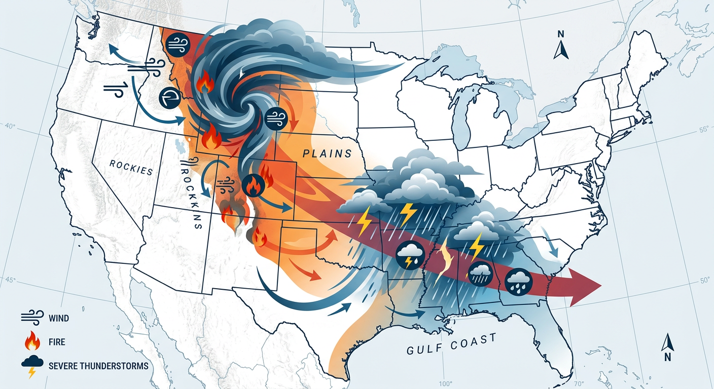
But the main event kicked off in the evening. A Mesoscale Convective System consolidated and pushed into the Mid-South and Deep South. We saw 70 mph convective wind gusts and golf ball-sized hail dropping in places like Amory, Mississippi. Things escalated quickly, prompting multiple Tornado Warnings across Mississippi and Alabama.
And right in the middle of this active convective weather at 20:21 UTC, a magnitude 4.4 earthquake rattled Edgefield, Louisiana. You really cannot make this stuff up, y'all.
Ground Truth vs. Forecast
Here is the thing. We knew a severe weather threat was coming to the Deep South, and the forecast largely verified. However, the exact intensity and rapid escalation of the flash flooding caught some folks off guard. A Flash Flood Emergency was issued for Baldwyn, Mississippi, after they saw torrential rainfall rates of 3 to 4 inches per hour.
As of this morning, we have 15 official severe weather reports from yesterday's storms. We saw the keyword "tornado" lighting up the warning data last night, specifically with radar-indicated rotation near Randolph, Mississippi. Early reports show significant wind damage, including an overturned semi-truck on Highway 13 in Fayette County, Alabama, and trees down on homes. We are still waiting on official National Weather Service damage surveys to confirm exactly how many tornadoes touched down versus what was caused by intense straight-line winds.
By The Numbers
Here are the confirmed facts and records from yesterday:
- 15 total severe weather reports logged so far.
- 92 mph non-thunderstorm wind gust recorded in Augusta, Montana.
- 1.75 inch (golf ball) hail reported in Amory, Mississippi.
- 3 to 4 inches per hour rainfall rates leading to a Flash Flood Emergency in Baldwyn, Mississippi.
- -55°F wind chills during a 15-hour blizzard on the Alaska North Slope.
- 4.4 magnitude earthquake near Edgefield, Louisiana.
What Meteorologists Can Learn
When we look back at days like March 9, the biggest takeaway is how connected the atmosphere really is. The same massive trough that brought 92 mph winds to Montana helped pull bone-dry air into Texas for fire weather, while simultaneously pumping Gulf moisture into Mississippi to fuel severe storms. It is a textbook example of a highly dynamic, multi-hazard spring storm system.
What Is Coming Next
Do not let your guard down just yet. The severe weather threat is shifting eastward today into the Ohio Valley and Mid-Atlantic. We have an Enhanced Risk (Level 3 out of 5) for severe storms across parts of Illinois, Indiana, and Ohio, where all severe hazards are possible again. Meanwhile, the Pacific Northwest is continuing to get hammered by an atmospheric river, bringing blizzard conditions to the Washington Cascades.
The Bottom Line
Yesterday was a harsh reminder that spring weather does not hold back. The transition from morning blizzards to evening tornadoes was intense, and the severe weather threat is not over for the eastern half of the country. Check your local forecasts today, make sure your weather radios have fresh batteries, and keep looking up.