Blog Article
March 10, 2026 Weather Recap: Tornadoes & Giant Hail
A complete recap of the violent March 10, 2026 tornado outbreak, including the Knox Indiana Tornado Emergency and record 5.2-inch hail in Illinois.

Tornadoes, Giant Hail, and Ice Jams: Recapping the March 10 Outbreak
Alright folks, let us take a deep breath. Yesterday, March 10, 2026, was one of those days that will be studied by meteorologists for a long time. We went into the day knowing things could get rough, but seeing it actually unfold is always a sobering experience.
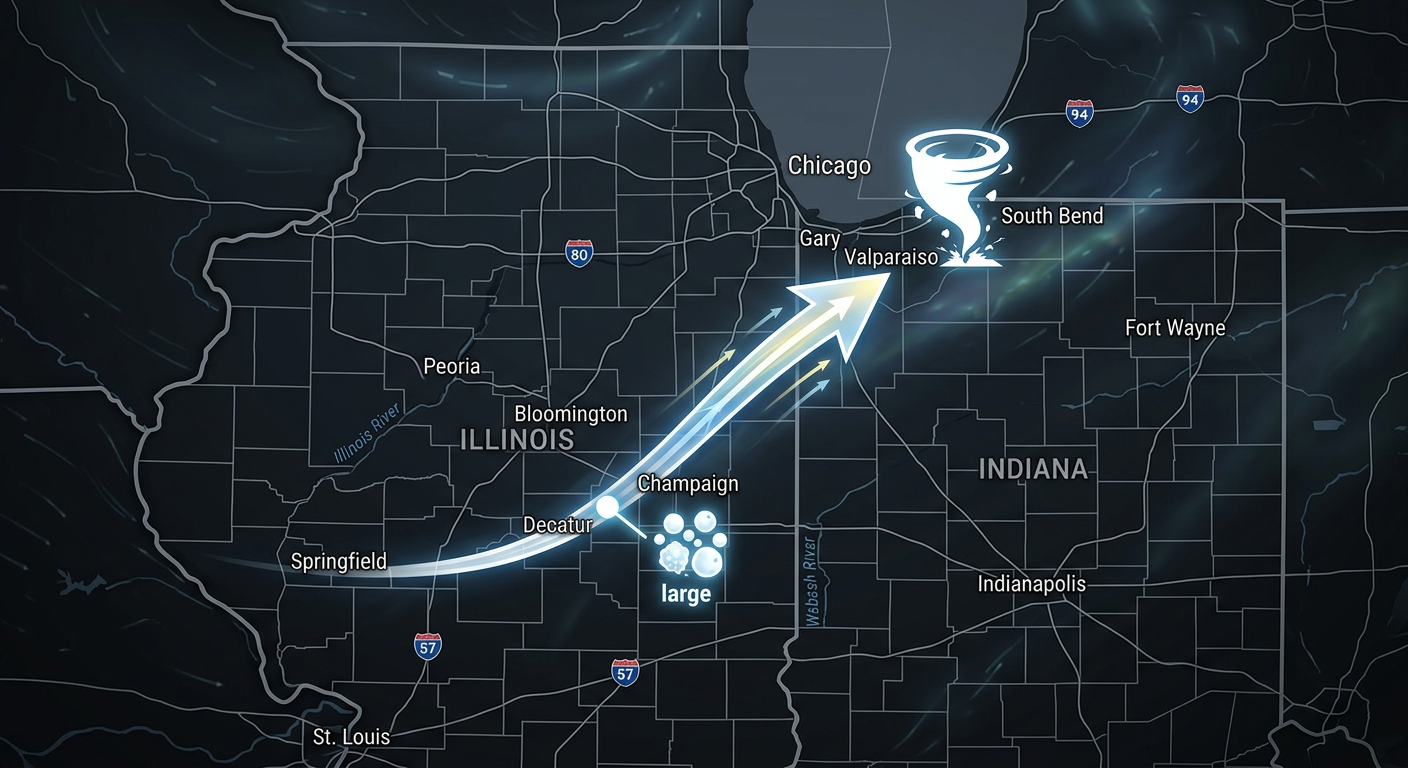
The headline of the day was undeniably the Midwest. We saw a particularly dangerous situation escalate into a rare Tornado Emergency for Knox, Indiana. Radar confirmed a debris signature reaching an incredible 20,000 feet into the atmosphere. That means a massive, destructive tornado was lofting pieces of buildings and trees miles into the sky.
Get this, y'all. Just across the border in Kankakee, Illinois, a storm dropped hail measuring 5.2 inches in diameter. That is larger than a grapefruit and easily among the largest hailstones ever recorded in that region.
Here is a complete breakdown of how March 10 played out, what the data is telling us today, and what is coming next.
How the Day Unfolded
The wild thing about yesterday is that the severe weather was only one piece of a massive, continent-spanning puzzle.
- The Morning: The day actually started with water and ice. Over in New York, a life-threatening ice jam formed on the Saranac River in Morrisonville. Water backed up so fast that emergency crews had to perform active evacuations. Meanwhile, out West, a massive atmospheric river was slamming the Washington Cascades with blizzard conditions and up to 4 feet of snow.
- The Afternoon Escalation: By mid-afternoon, the sun came out over the Midwest and Southern Plains. That sunshine acted like a match dropping into a pool of gasoline. The atmosphere rapidly destabilized.
- The Peak: By the evening hours, we saw violent supercells explode across Illinois and Indiana. This is when the "Particularly Dangerous Situation" (PDS) Tornado Warnings were issued for Kankakee County, Illinois, and Starke County, Indiana. Down south, Texas wasn't spared either, with 80 mph wind gusts and baseball-sized hail smashing into the Dallas-Fort Worth and Abilene regions.
- The Aftermath: By the time the clock struck midnight, the Storm Prediction Center had logged 26 official severe weather reports, though that number will likely grow as damage surveys are completed.
Ground Truth: Forecast vs. Reality
Here is the thing about meteorology. We can see the ingredients, but we never know exactly how the cake is going to bake until it happens.
The Storm Prediction Center had a Level 4 out of 5 "Moderate Risk" painted right over Illinois and Indiana. In terms of location and severity, the forecast was incredibly accurate. The atmosphere delivered exactly what the models feared.
However, there were still surprises. The sheer size of the 5.2-inch hail in Illinois was an extreme, high-end realization of that risk. Hail that large requires unimaginable updraft speeds inside the thunderstorm, suspending chunks of ice in the air long enough for them to grow to the size of softballs.
We also have to acknowledge the human impact. Early reports confirm an EF-3 tornado in Union City, Michigan, from early activity associated with this system, which tragically resulted in three fatalities. Flash flooding also caused major issues, with active water rescues for submerged vehicles happening in Ottawa County, Michigan.
What We Can Learn
If there is one lesson to take away from yesterday, it is the importance of respecting the ceiling of a forecast. When meteorologists issue a Moderate Risk and start using words like "Particularly Dangerous Situation," it means the atmosphere is primed for historical extremes.
This event also proved how interconnected our weather systems are. The same massive trough of low pressure that caused a magnitude 4.4 earthquake in Louisiana to coincide with flood warnings also helped trigger the blizzard in the Pacific Northwest and the giant hail in the Midwest. The atmosphere is just one big, fluid machine.
What Is Coming Next
The storm system that caused all this chaos is not done yet, but it is changing its shape.
Today, a strong cold front is sweeping eastward. Temperatures behind this front are going to absolutely plummet, dropping 15 to 30 degrees across the East and returning things to a much more seasonable, chilly feel.
Here is what you need to watch for today and tomorrow:
- Severe Threat Shifts East: There is a Level 2 "Slight Risk" for severe storms today stretching from the Lower Mississippi Valley up into the Ohio Valley and Mid-Atlantic.
- Critical Fire Weather: Behind the front, incredibly dry air and strong winds are moving into the Southern Plains. There is a Critical Fire Weather risk for eastern New Mexico, the Texas Panhandle, and western Oklahoma. With winds gusting 25 to 35 mph and humidity dropping to 15 percent, any spark will spread rapidly.
- More Snow: A clipper system is going to drop a quick 6 to 12 inches of snow across northern Michigan and Wisconsin, while the Washington Cascades continue to get buried under blizzard conditions.
The Bottom Line
March 10, 2026, delivered a high-end, violent severe weather outbreak exactly where it was forecast, but with extremes that still managed to shock us. From 5.2-inch hail to a Tornado Emergency in Indiana, it was a day that tested infrastructure and emergency preparedness to the limit.
As this system moves east, the threat transitions from violent tornadoes to damaging wind, rapid temperature drops, and massive fire danger in the Plains. Please stay weather aware, check your local forecasts, and look out for your neighbors.