Blog Article
March 13, 2026 Weather Recap: Historic Snow & High Winds
Read our complete March 13, 2026 weather recap. We break down the historic 54-inch Wisconsin snowfall, 85 mph Ohio winds, and Hawaiian flash flooding.
March 13, 2026 Severe Weather Recap: A Day for the Record Books
Alright folks, we need to talk about what just happened yesterday. On March 13, 2026, the weather threw just about everything it had at us. We knew a strong clipper system was going to cause trouble, but the way it deepened and expanded its wind field caught a lot of folks off guard. And get this, we even had a wild combination of events out in Hawaii. Let us break down this March 13, 2026 weather recap.
The Headline Makers: Wind and Whiteouts
Here is the thing about clipper systems. When they deepen rapidly, they bring down some incredibly strong winds from higher up in the atmosphere right to our backyards. Yesterday morning, things kicked off in the West. Dakota Hill, Colorado recorded a massive 90 mph non-thunderstorm wind gust. Meanwhile, the Twin Lakes SNOTEL site in Montana measured a 48-hour snowfall total of 34 inches.
As the day went on, the system moved east and exploded in intensity over the Upper Midwest and Great Lakes.
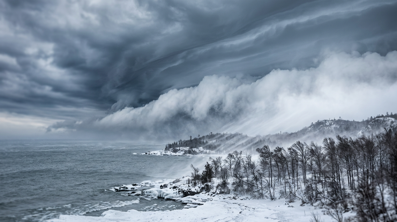
- Record Snowfall: Marshfield Municipal Airport in Wisconsin reported a jaw-dropping 54 inches of snow in just 24 hours. That is a historic, record-breaking measurement for the region.
- Blizzard Conditions: Northeast Minnesota and Wisconsin were completely blinded by snow. Gile, Wisconsin picked up a solid 17 inches of accumulation.
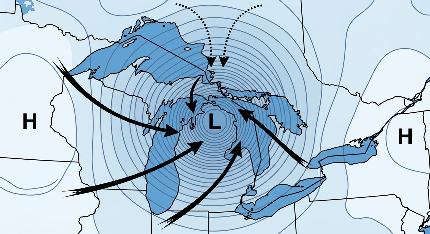
The Ohio Valley Takes a Beating
By the afternoon and evening, the wind field expanded right into the highly populated areas of the Eastern U.S. We are talking about severe, non-convective winds. That means there was not a thunderstorm in sight, but the winds were still strong enough to cause massive destruction.
- In Tiffin, Ohio, a 77 mph gust caused major roof failures at Columbian High School.
- Cleveland, Ohio recorded an 85 mph gust. That is one of the highest non-thunderstorm wind gusts ever recorded in that area.
- Across Ohio, Indiana, and Pennsylvania, these winds knocked out power to over 339,000 customers.
The Hawaiian Surprise
While the mainland was dealing with snow and wind, Hawaii experienced a highly unusual and dangerous day. Y'all, it is incredibly rare to see seismic and weather emergencies peak at the exact same time. First, a Magnitude 4.4 earthquake rattled the area near Pahala at a depth of 34km. Then, life-threatening flash flooding took over Oahu. The Wahiawa Reservoir actually overtopped its spillway, forcing emergency evacuations at Otake Camp.
What We Learned
When we look back at the forecast versus what actually happened, the models had an excellent handle on the storm track. However, the sheer magnitude of the wind gusts in Ohio and the localized extreme snowfall band in Wisconsin exceeded the most likely scenarios. Meteorologists can learn a lot from this event about how rapidly deepening surface lows can transfer high-momentum air to the surface, even outside of severe thunderstorms.
What Comes Next: Severe Threats for Sunday and Monday
The weather is not calming down anytime soon. Looking ahead at the current data, we have a major shift coming.
- Severe Thunderstorms: The Storm Prediction Center has highlighted an Enhanced Risk for severe weather on Sunday (Day 2). This covers a huge area from the ArkLaTex region up into southern Illinois and Indiana. We are looking at a widespread damaging wind event and a tornado threat. By Monday (Day 3), that Enhanced Risk shifts to the Carolinas, Virginia, and southern Pennsylvania.
- Fire Weather: Meanwhile, the Southwest is drying out. Critical fire weather is expected across New Mexico, eastern Colorado, and West Texas due to strong westerly winds and low humidity.
- Western Heat: An early season heatwave is going to build over the western U.S. next week, which will rapidly accelerate snowmelt.
Bottom Line
March 13 was a stark reminder of how powerful non-thunderstorm winds can be. If you live in the Ohio Valley and lost power, I know it has been a rough 24 hours. For everybody in the path of Sunday and Monday's severe weather threats, you need to use this weekend to get your weather radios ready and have a plan in place. Stay safe, y'all.