Blog Article
March 15, 2026 Severe Weather & Winter Storm Recap
Read the complete March 15, 2026 severe weather recap. From confirmed tornadoes in Arkansas and Kentucky to 141 mph winds in Wyoming and historic Midwest snow.

March 15, 2026 Severe Weather Recap: A Nationwide Emergency
Alright folks, yesterday was one of those days that will go down in the weather history books. We knew we were looking at a highly dynamic system, but the way things escalated across the country on March 15, 2026, was truly staggering. We transitioned from localized winter and flood impacts straight into a nationwide multi-hazard emergency.
Here is the thing y'all need to understand about yesterday. The atmosphere was firing on all cylinders. From the Intermountain West all the way to the Mid-Mississippi Valley, we saw extreme, record-breaking weather that tested the limits of what we usually see in mid-March.
How the Day Unfolded
The day started off with some serious hydrological issues way out in the Pacific. Down in Hawaii, life-threatening flash flooding caused South Kihei Road to completely collapse, isolating several communities.
As the main system pushed across the continental United States, the wind energy was absolutely off the charts. Get this, the Mount Coffin Mesonet in Wyoming recorded a non-thunderstorm wind gust of 141 mph. Let me repeat that. 141 mph without a single thunderstorm in sight. Monarch Pass in Colorado also clocked a 101 mph gust.
By the afternoon and evening, the severe convective threat took over. A severe squall line developed across the Tennessee Valley with forward storm motions exceeding 90 knots. When storms are moving that fast, warning lead times drop to near zero, and the wind damage potential is massive.
Ground Truth: What Actually Happened
We had multiple confirmed tornadoes yesterday. The data we are looking at this morning confirms some intense structural impacts and incredibly dangerous situations on the ground.
- Confirmed Tornadoes: A spotter in Wickliffe, Kentucky, actually drove through a tornado's circulation. Down in Northeast Arkansas, the National Weather Service confirmed a tornado on the ground near Minturn, moving northeast at a blistering 55 mph.
- Historic Snowfall: While the South was dealing with tornadoes, the Upper Midwest was getting completely buried. Marinette, Wisconsin, recorded a historic 28 inches of snow, and Spalding, Michigan, picked up 26 inches.
- Aviation Impacts: The sheer turbulence in the atmosphere caused a mass casualty incident over Orange County, Florida, where severe flight turbulence injured four people.
What We Are Watching Today
Now that yesterday's system is pulling away, the severe weather threat is shifting east for today, March 16. The Storm Prediction Center has issued a rare Day 1 Moderate Risk for severe thunderstorms across parts of central Maryland, central and eastern Virginia, and central North Carolina.
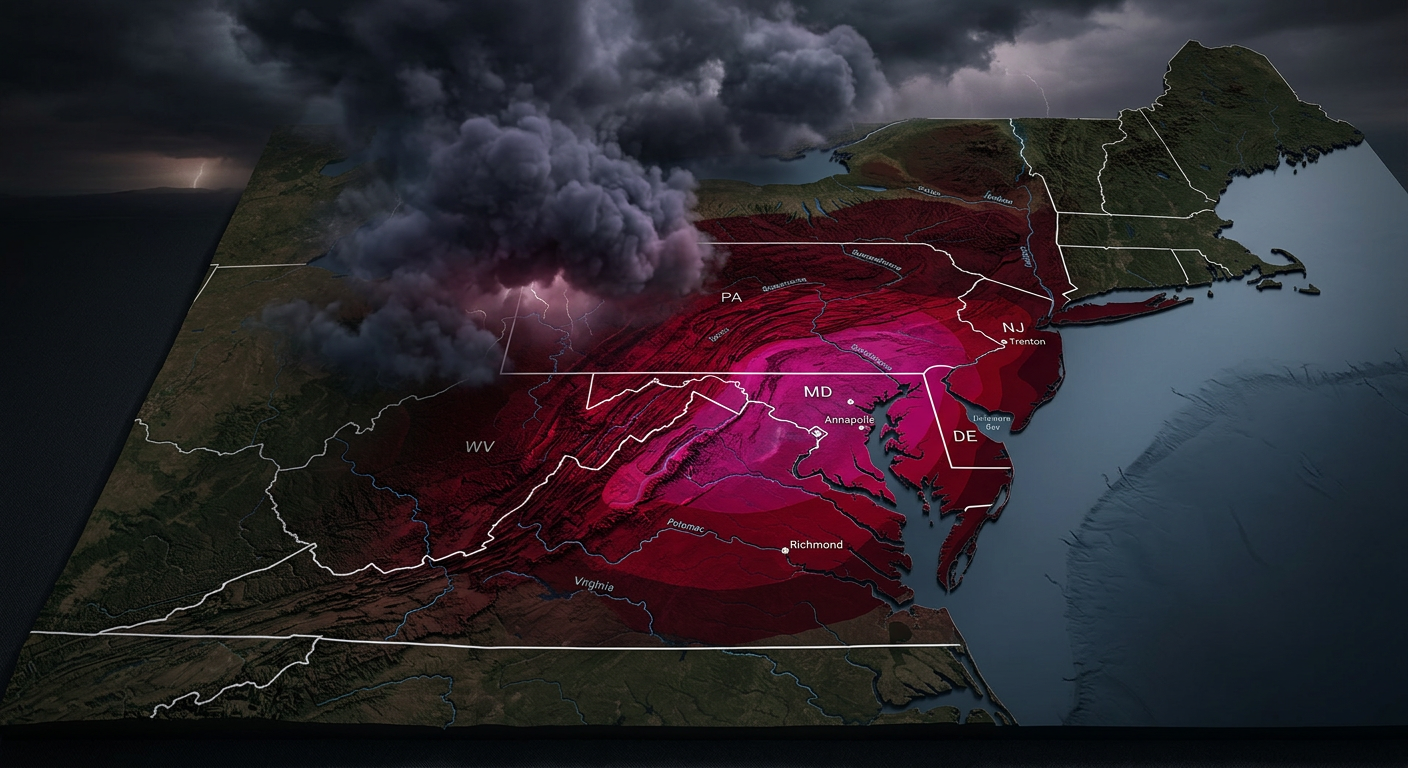
If you live in places like Washington DC, Raleigh, Richmond, or Baltimore, you need to be on high alert today. Fast-moving thunderstorms could bring damaging wind gusts and a few tornadoes, and there is a very real potential for a couple of strong, long-track tornadoes.
Meanwhile, the western US is trading those extreme winds for an anomalously early heatwave, while the historic blizzard in the Upper Midwest finally pulls away into Canada by tomorrow morning.
The Bottom Line
The March 15 event was a textbook example of how a powerful upper-level trough can produce wildly different, yet equally dangerous, hazards across the country. The biggest takeaway for meteorologists and the public alike is the sheer speed of this system. With storm motions exceeding 90 knots in the squall line and 55 mph for individual tornadoes, hesitation was not an option. If y'all are in the Mid-Atlantic today, take yesterday as a warning. Have your alerts on, know your safe space, and do not wait to take cover if a warning is issued.