Blog Article
March 31, 2026 Severe Weather Recap: Hail, Wind, and Floods
Read our full March 31, 2026 weather recap. We break down the Texas baseball hail, the Ohio Valley wind damage, and the New York flash flood emergency.
The March 31 Severe Weather Recap
Y'all, yesterday was one of those days where the atmosphere decided to throw the whole kitchen sink at us. We had a widespread severe weather outbreak that stretched from the Midwest all the way into the Northeast. We saw wind, giant hail, and life-threatening water issues.
Here is the thing about a setup like this. When you have a massive system covering half the country, the impacts are going to vary wildly from town to town. Let's look at exactly what happened out there.
How The Day Unfolded
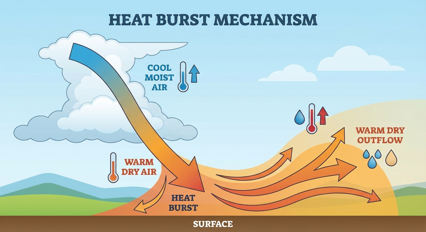
Get this, the weird weather actually started early in the morning. Out in Burns Flat, Oklahoma, an automated station recorded a 68 mph wind gust just before 4 AM. That was not from a severe thunderstorm. That was a rare heat burst, where dying showers cause a sudden rush of hot, dry air to accelerate down to the ground.
By the afternoon and evening, the main events took over. A high-speed line of storms, known as a QLCS, raced across Northeast Ohio. The Cleveland metro area went under a Tornado Warning just before 10 PM Eastern when radar indicated rotation embedded in that line. The Edgewater mesonet measured a 75 mph wind gust, and we saw structural roof damage in nearby Brooklyn, Ohio.
Further east, the water simply became too much. Central and Western New York dealt with a Flash Flood Emergency. The rain came down so hard and fast that a bridge washed out completely at the intersection of Shongo Valley Road and McClure Hill Road in Allegany County.
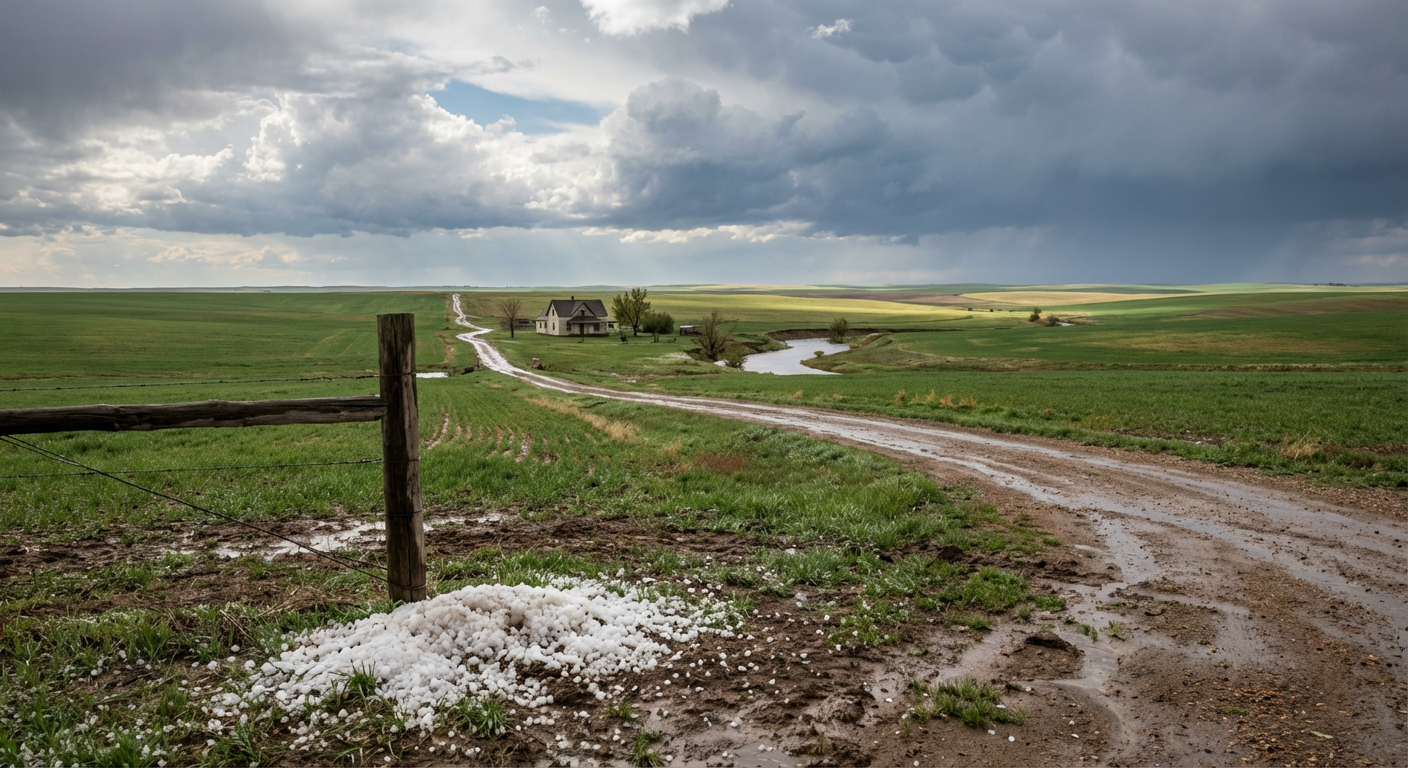
Meanwhile, down south, the Texas Panhandle saw the atmosphere tap into some serious energy. A spotter near Childress, Texas, reported hail 2.75 inches in diameter. That is baseball-sized ice falling from the sky.
Forecast vs. Reality: How Did We Do?
We always want to look back and see how the forecast held up. In yesterday's blog, we talked about the Storm Prediction Center highlighting an Enhanced Risk for Oklahoma, Kansas, and northern Texas. We specifically called out the threat for massive hail and damaging winds. That part of the forecast verified perfectly. The baseball hail in Childress and the intense winds in Oklahoma lined up exactly with expectations.
We also mentioned a Slight Risk for excessive rainfall from central Oklahoma up into Missouri. While that area did see heavy rain, the most extreme, life-threatening flooding actually happened much further northeast in New York. The sheer intensity of the QLCS wind damage in Ohio and the bridge washouts in New York ended up being the most dramatic impacts of the day. It is a humbling reminder that severe impacts can happen well outside the main highlighted risk zones.
The Numbers That Matter
- 75 mph: The peak wind gust measured at the Edgewater mesonet in Cleveland, Ohio.
- 2.75 inches: The diameter of the hail reported in Childress, Texas.
- 68 mph: The severe-level wind gust produced by a rare morning heat burst in Oklahoma.
- 1: Flash Flood Emergency issued in New York, resulting in a confirmed bridge washout.
What Is Coming Next
Alright folks, the severe weather pattern is not taking a break. Today, April 1, the SPC has an Enhanced Risk right back over the southern Plains, including places like Wichita Falls and Oklahoma City. We are looking at another round of large hail, damaging winds, and a few possible tornadoes.
By Thursday, that severe threat shifts up into the Midwest and Great Lakes, with a Slight Risk covering Chicago, Indianapolis, and Milwaukee. Then on Friday, a completely separate system drops in, bringing an Enhanced Risk to southern Iowa and northern Missouri.
Bottom Line
Yesterday proved that water can be just as destructive as wind. The folks in New York who lost a bridge to flash flooding did not have a tornado warning, but their lives were still heavily impacted. Always respect the power of moving water, and never ignore a warning just because you are outside the worst-looking colors on a forecast map.