Blog Article
May 16, 2026 Severe Weather Recap: Tornadoes & 88 MPH Winds
Read our complete May 16, 2026 severe weather recap. We break down the confirmed tornadoes, 88 mph wind gusts in Kansas, and flash flooding in Missouri.
May 16, 2026 Severe Weather Recap: When The Atmosphere Delivers
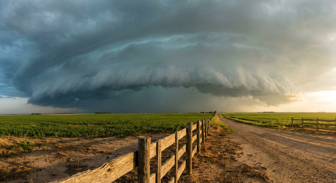
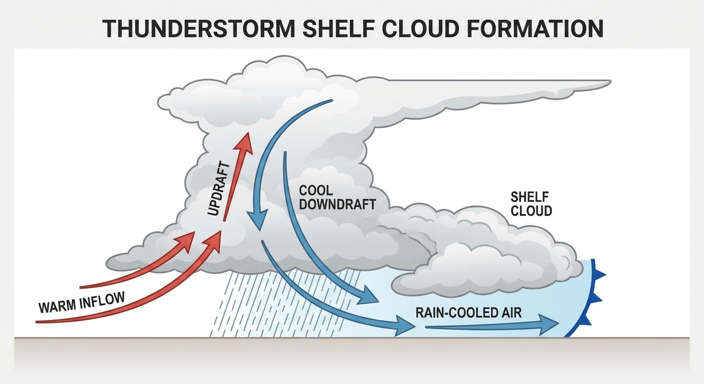
Y'all, yesterday was a classic example of a forecast verifying right in front of our eyes. We talked about the threat for intense straight-line winds and severe storms, and the atmosphere did exactly what it said it was going to do. The standout moment? That measured 88 mph wind gust near Colby, Kansas. When you get winds approaching 90 mph, you are talking about structural damage territory.
Let us walk through how May 16 unfolded. The day started with isolated morning cells, but things escalated quickly into the late evening. We watched those discrete storms merge into widespread, high-impact convective systems. By the time the sun went down, the Storm Prediction Center had issued multiple Severe Thunderstorm Watches across the Midwest and Ohio Valley, alongside Tornado Watch 210.
Ground Truth: Tornadoes And Straight-Line Winds
We had four confirmed tornado reports yesterday. Spotters and storm chasers reported a brief, multi-vortex tornado just south-southeast of Gravity, Iowa. We also had a brief tornado confirmed by an NWS employee near Edson, Kansas, and a narrow tornado reported by the public near Beatrice, Nebraska. Out in Wyoming, spotters even caught photos of a couple of landspouts near Yoder.
The wind and rain were just as impactful as the rotation. In Kearney, Nebraska, severe thunderstorm winds took down power poles and dropped lines onto residential homes. Up in Wisconsin, a spotter near Oregon reported an unsecured soccer goal blown 100 yards across a field. Meanwhile, the rain just kept coming in northern Missouri. Near Tindall, rainfall totals hit 3 to 6 inches, leading to a flash flood water rescue.
Forecast vs. Reality
Looking back at our previous forecast, we nailed the primary threats. We warned y'all about that 88 mph gust in Colby and the Enhanced Risk setup. The transition from a hail and wind threat into a messy, heavy-rain producing system was right on schedule.
It was not just severe storms yesterday, either. The Texas Panhandle saw critical fire weather with relative humidity dropping to a bone-dry 4 percent. And out west, the Cascades picked up a late-season Winter Weather Advisory with up to 18 inches of snow forecast above 5,000 feet.
What Comes Next
Here is the thing. We do not get a break. Today, May 17, we have an Enhanced Risk for severe storms across the Central Plains and Middle Missouri Valley, including Omaha and Lincoln. We are looking at a 15 percent hatched risk for tornadoes.
Then tomorrow, Monday, things escalate further. The Storm Prediction Center has issued a Moderate Risk for central and northeast Kansas into southeast Nebraska. We are talking about the potential for very large hail up to 3.5 inches and strong tornadoes. At the same time, an Extremely Critical fire weather area is in place for parts of New Mexico, Colorado, Kansas, and the Texas/Oklahoma Panhandles.
Bottom Line
- This May 16, 2026 severe weather recap shows exactly why we take these setups seriously. Wind and water were the primary drivers of damage.
- The severe weather engine is still running, and Monday looks highly concerning for the Plains.
- Flash flooding remains a massive threat when these storm complexes train over the same areas.
- Have multiple ways to receive warnings today and tomorrow, especially if you live in Kansas, Nebraska, or Iowa.