Blog Article
May 22, 2026 Severe Weather Recap: Tornadoes and Flooding
A complete recap of the May 22, 2026 severe weather event, including Texas landspouts, an EF-1 tornado in Alabama, and extreme Gulf Coast flash flooding.

Recapping May 22: Texas Landspouts, Gulf Coast Floods, and an Alabama EF-1
Y'all, yesterday was a busy one. The atmosphere gave us a little bit of everything across the country. We saw a rare landspout outbreak in the Texas Panhandle, severe thunderstorms in the Deep South, and a late-season freeze up Northeast that had folks scraping their windshields in late May.
Here is the thing about transition seasons. The weather does not always fit neatly into one box. Yesterday started with 22-degree temperatures in the Upper Midwest and Northeast, but by the afternoon, we were tracking severe convection from the High Plains all the way to the Ohio Valley.
How the Day Unfolded
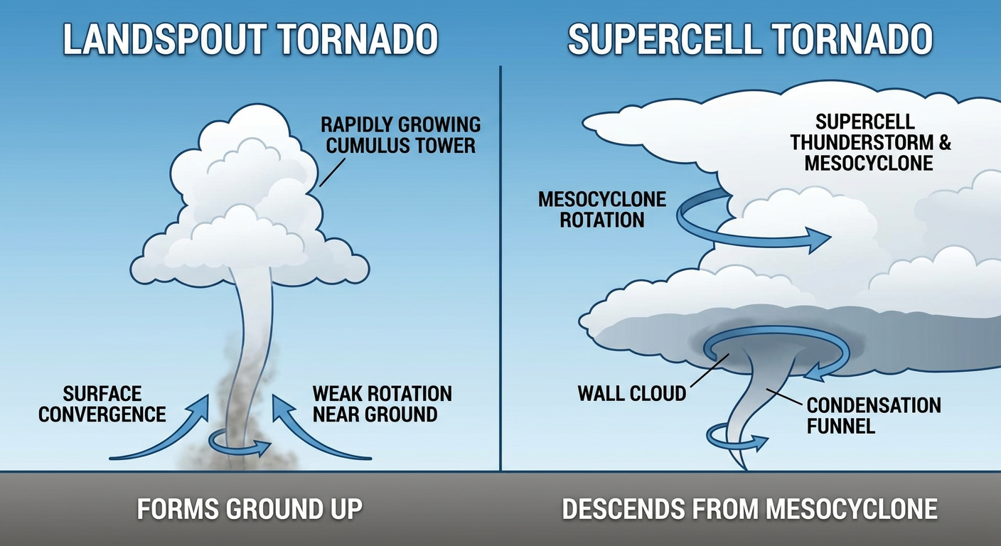
The most visually striking moments of the day came out of the Texas Panhandle. We had a significant outbreak of landspout tornadoes near towns like Abernathy, Happy, Lazbuddie, and Spade. Storm chasers and spotters reported multiple dusty tornadoes touching down in open fields.
At the same time, those Texas storms were dropping massive hail. We saw measured baseball-sized hail, about 2.75 inches in diameter, near Bushland. Another report near Plainview clocked in at 2.66 inches.
Further east, the Deep South dealt with a more traditional severe threat.
- Alabama: An NWS storm reported an EF-1 tornado in eastern Tuscaloosa County, about three miles north of Vance. That tornado had winds up to 95 mph, a path length of 2.65 miles, and a maximum width of 150 yards. We also saw a radar confirmed tornado near Abernant.
- Mississippi: A storm chaser reported a tornado south of Raymond. They observed a thin funnel and tree damage, and radar picked up a debris signature shortly after.
- Midwest Brief Spin-ups: We also had brief, photograph-confirmed tornado reports in Oto, Iowa, and Murray, Nebraska.
The Forecast vs. Reality
In our previous update, we talked heavily about the Gulf Coast downpours. We highlighted the Weather Prediction Center's outlook for excessive rainfall, and unfortunately, that forecast verified exactly as expected.
Mobile and Baldwin Counties in Alabama saw 6 to 10 inches of observed rainfall. The tropical moisture profile over the region resulted in life-threatening flash flooding and multiple water rescues. When the ground is already saturated, those slow-moving storms are incredibly dangerous. The forecast nailed the location and the threat level, but seeing 10 inches of rain actually fall is always a sobering reality.
We did not spend as much time yesterday talking about the landspout threat in Texas, but that is the nature of landspouts. They form quickly under rapidly developing updrafts, often before a storm even looks severe on radar.
What Comes Next
The severe weather focus is now shifting northward. For Sunday, the Storm Prediction Center has a Marginal Risk for severe storms from central Nebraska into southwest Minnesota. Inside that risk area, there is a specific zone where hailstones could reach two inches in diameter.
Meanwhile, the heavy rain threat is not over for the South. The WPC has a Slight Risk for excessive rainfall today across eastern Texas and western Louisiana. Places like Houston and Lake Charles need to stay alert, as the soils are completely waterlogged.
Bottom Line
Yesterday was a stark reminder that severe weather comes in many forms. From landspouts in Texas to an EF-1 in Alabama and extreme flooding on the Gulf Coast, the impacts were widespread. As we move through the rest of this holiday weekend, keep an eye on the sky, especially if you live in the Central Plains or along the Texas coast.