Blog Article
June 09, 2026 Severe Weather Recap: Tornadoes & Flooding
A full recap of the June 09, 2026 severe weather outbreak, including a 113 mph wind gust in Kansas, 8 inches of rain in Indiana, and tornadoes in Michigan.

Y'all, yesterday was one of those days where the atmosphere threw a little bit of everything at us. We saw a 113 mph wind gust in Kansas, emergency boat rescues in Indiana, and tornado damage up in Michigan. The forecast called for a widespread severe threat, and the data shows that is exactly what we got.
How the Day Unfolded
The day started with a focus on extreme wind. Out in Kansas, the ASOS at Salina Regional Airport measured a 113 mph wind gust. That is an extreme wind event for the region. We also had reports of downed power poles and scattered tree damage near Reading, Kansas.
By mid-day, the threat transitioned to water. The Ohio and Tennessee Valleys saw widespread flash flooding. Lanesville, Indiana, picked up a measured 8 inches of rain from a single convective event. That led to emergency boat rescues. Over in Kansas, Topeka and Abilene dealt with life-threatening flash flooding, with water rescues and 3.5 feet of water over the roads.
As we moved into the evening, the severe weather outbreak escalated across the Plains and Great Lakes. Emergency managers reported a tornado near Freeland, Michigan. That storm caused roof and siding damage to 30 to 40 homes and overturned several campers. A trained spotter also caught video of a brief tornado in a farm field near Montrose, Michigan. Down in Indiana, law enforcement confirmed a multiple vortex tornado near Franklin. Out in North Dakota, a storm chaser reported a tornado east of Noonan.
Ground Truth: What We Got Right
In yesterday's blog, we talked about a widespread damaging wind threat targeting the Midwest. We also highlighted the tornado potential and the excessive rainfall risk. The atmosphere did exactly what it said it was going to do.
The Weather Prediction Center had a Slight Risk for excessive rainfall, and that 8-inch total in Indiana proves why you have to take those risks seriously. The Storm Prediction Center's Enhanced Risk verified with multiple confirmed tornadoes and destructive wind gusts. The forecast was accurate, and that advanced warning gave folks time to prepare.
The Science Behind the Storms
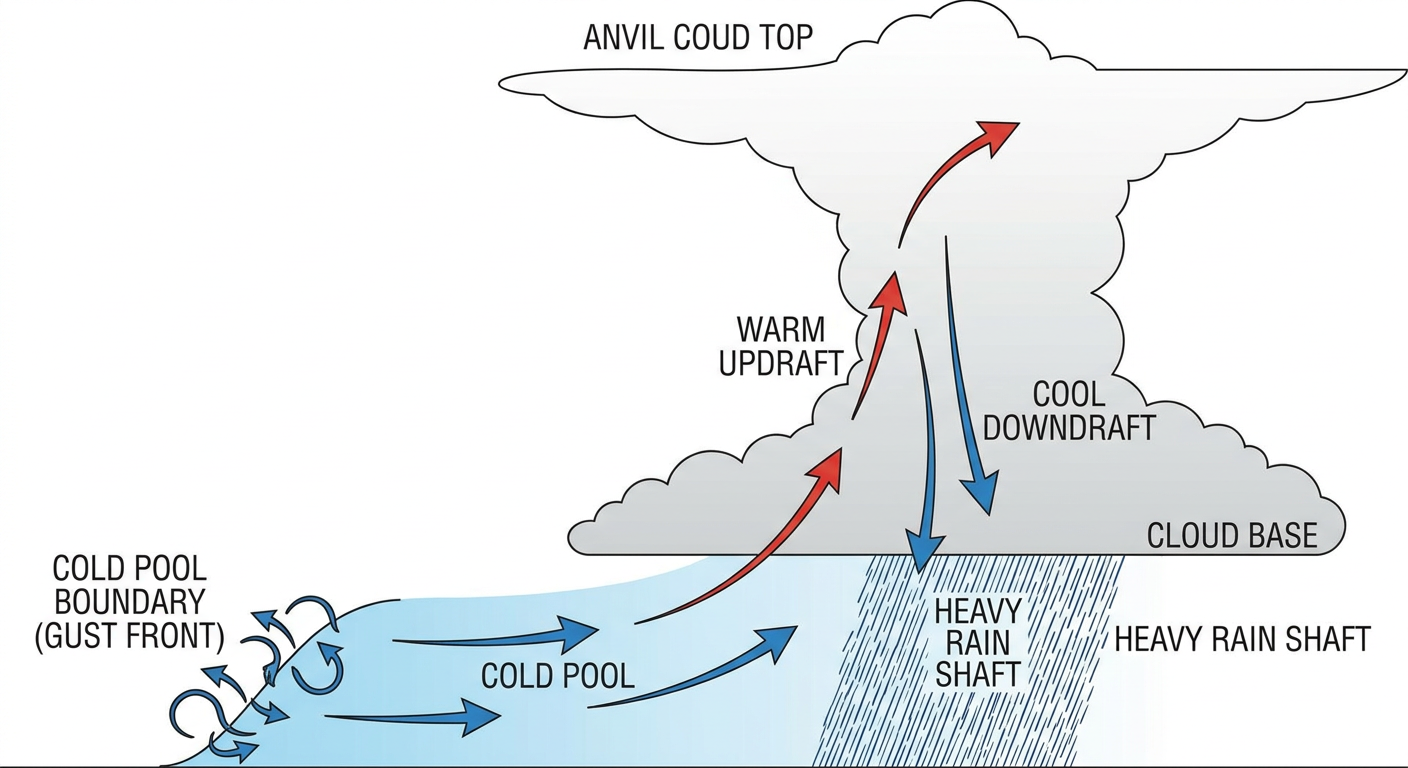
When you see a day transition from straight-line winds to flash flooding and then to tornadoes, you are watching storm modes evolve. Early on, cold pools merge and push out ahead of the storms, creating those massive wind gusts like we saw in Salina. As boundaries stall out, storms train over the same areas, dumping extreme rainfall. By evening, discrete supercells can tap into the low-level shear to produce tornadoes.
The Threat Continues
The severe weather is not over. The Storm Prediction Center has an Enhanced Risk posted for today across parts of the Upper Mississippi Valley and Midwest. We are looking at the potential for gusts over 75 mph and hail up to 2 inches in diameter.
Tomorrow looks even more intense. The SPC has issued a Level 4 out of 5 widespread damaging wind threat for Day 2. That covers parts of the Midwest, including Illinois, Indiana, and southern Michigan. The probability for damaging winds is at 45 percent. We are talking about the potential for widespread tree and power line damage.
Bottom Line
Yesterday brought extreme impacts from Kansas to Michigan. We saw homes damaged, roads flooded, and incredible wind speeds. The forecast was accurate, and warning lead times helped keep folks safe. Now, we have to look ahead. The Midwest remains in the crosshairs for severe storms today and tomorrow. Have your severe weather plan ready, and keep your weather radio on.