Blog Article
June 25, 2026 Severe Weather Recap: 101 MPH Gust, Tornadoes
June 25, 2026 recap: a measured 101 mph gust near Boise City, OK, two tornado reports, 14 RVs flipped near Wheeler, TX, and water rescues across the Plains.

June 25, 2026 Recap: A 101 MPH Gust, Two Tornadoes, and a Long Day Across the Plains
Alright folks, the number that jumped off the page yesterday was 101. As in 101 miles per hour. That was a measured severe convective wind gust near Boise City, Oklahoma, way out in the Oklahoma Panhandle. To put that in plain terms, that's a wind speed you'd associate with a strong tornado, except this was straight-line wind coming out of a thunderstorm. For that part of the High Plains, that's an extreme event.
Here's the thing. Yesterday wasn't about one single moment. It was about a day that started rough and got rougher, hour by hour, from the High Plains down into the Ozarks.
How the Day Unfolded
The trouble started early and out over the water. Before sunrise, broadcast media reported multiple waterspouts south of Port Fourchon, Louisiana, around 12:46 UTC (LSR from NWS New Orleans). Those were verified by photo. Not severe-weather headline material on their own, but a sign the atmosphere was already restless.
Things sharpened up through the afternoon across the Plains. Around 21:18 UTC, an NWS employee reported a tornado on the ground 5 miles north of Elmwood in Beaver County, Oklahoma (LSR from NWS Amarillo). That one was confirmed with photo and video. The report noted it was unclear whether the tornado stayed on the ground the entire time, and the location was estimated from observers and radar.
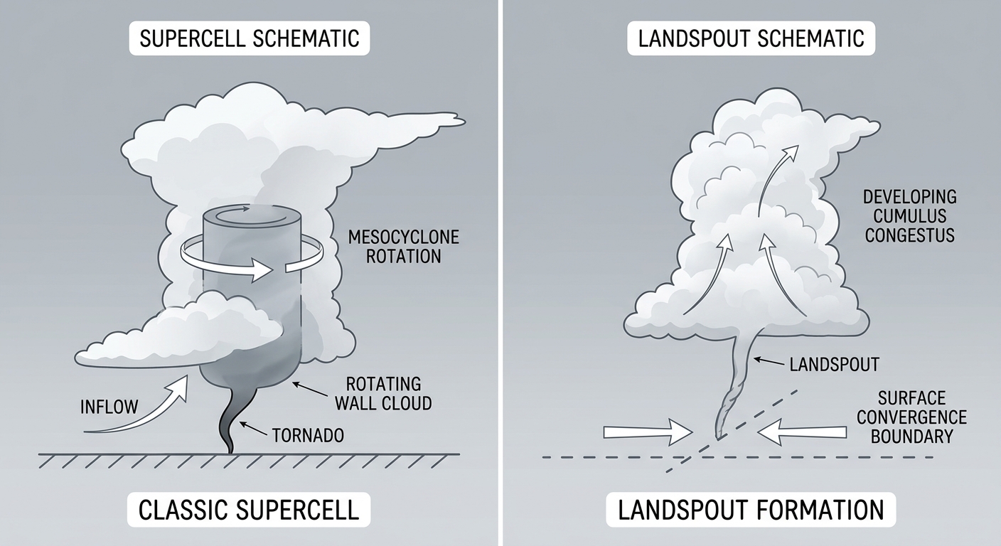
Around the same window, near Los Lunas, New Mexico, the public reported a landspout with video showing a debris cloud and flashing power lines (LSRs from NWS Albuquerque, 21:30 UTC). Different beast than a classic supercell tornado, but still a spin-up worth respecting.
Then the wind took over. The biggest punch came after dark. Near Wheeler, Texas, at 00:56 UTC, an emergency manager reported 14 RVs overturned and power lines snapped at Wheeler RV Park, with one injury (LSR from NWS Amarillo). That's the kind of report that sticks with you. RVs are light and exposed, and 14 of them going over tells you the wind was serious.
The wind threat kept rolling east. Power lines came down in Scammon, Kansas (LSR from NWS Springfield, 02:05 UTC). Trees fell across roads near Saint Matthews, Kentucky (LSR from NWS Louisville). Even back east in Hyde, Pennsylvania, a tree came down on McPhearson Street (LSR from NWS State College).
The Water Story
While the wind grabbed attention, the water was just as dangerous. Emergency services ran multiple critical water rescues for motorists and residents trapped in floodwaters in Rogers County, Oklahoma, and Greene County, Missouri. The Weather Prediction Center had flagged this exact corridor, with a Moderate Risk of excessive rainfall centered over southeastern Kansas into southwestern Missouri and training storms expected overnight. That call held up.
What We Got Right, What Surprised Us
Let me be straight with you. The flooding setup was forecast well. The heavy-rain corridor from the Ozarks into the mid-Mississippi Valley played out close to what was advertised, and the water rescues happened right where the highest risk sat.
The wind was the part that overdelivered in spots. A 101 mph measured gust near Boise City and 14 flipped RVs near Wheeler are on the high end of what a typical severe wind day produces. The ingredients were there for damaging gusts, and the atmosphere found the upper range.
The tornado reports, two confirmed on the ground near Elmwood, Oklahoma, and the landspout activity near Los Lunas, were lower-end and isolated, which matches a day where wind and water were the headline hazards rather than long-track tornadoes.
Quick Hits To Remember
- 101 mph measured convective wind gust near Boise City, Oklahoma. An extreme wind event for the region.
- Two tornadoes reported on the ground, including one near Elmwood in Beaver County, Oklahoma, confirmed with photo and video.
- 14 RVs overturned with 1 injury near Wheeler, Texas, at Wheeler RV Park.
- Water rescues in Rogers County, Oklahoma, and Greene County, Missouri.
- A PDS Red Flag Warning covered most of Utah for critical fire weather, a high-severity alert.
- Wind damage reports stretched east into Kansas, Kentucky, and Pennsylvania.
What's Coming Next
The pattern doesn't shut off, but it does shift. The Storm Prediction Center has a Slight Risk today across parts of the Ozark Plateau into the lower Ohio Valley, including Louisville and Springfield, plus a piece across the northern Rockies into the adjacent Plains near Billings. Damaging gusts and isolated severe hail are the main concerns, with a 5 percent tornado threat in the higher area.
The rain threat is sliding too. WPC keeps a Slight Risk of excessive rainfall in play, and after a wet 24 hours, the ground across the Ozarks and lower Ohio Valley doesn't have much room left to soak up more.
Looking to Saturday, the severe focus moves to eastern Montana into the Dakotas and a separate piece across southeast Virginia into northeast North Carolina, with a hatched zone in the northern Plains for 75 mph gusts and hail up to 2 inches.
Bottom Line
June 25, 2026 was a wind-and-water day more than a tornado day. The flooding forecast verified, the heavy-rain corridor delivered right where it was supposed to, and the wind found the high end with a measured 101 mph gust and 14 flipped RVs. If you take one thing away, it's that straight-line wind deserves the same respect you give a tornado warning. It flipped campers and snapped power lines across multiple states yesterday, and the same broad pattern keeps the Ozarks and Ohio Valley in play again today.