Blog Article
June 26, 2026 Severe Weather Recap: Floods & 110 MPH Wind
June 26, 2026 recap: a Wichita flash flood emergency, a 110 mph gust near Slaton TX, an EDS warning in Oklahoma, and six tornado reports. What happened vs. the forecast.
June 26, 2026 Recap: Flood Emergencies, a 110 MPH Gust, and Tornadoes on the High Plains
Alright folks, here's the thing about June 26. It wasn't one storm or one headline. It was a whole menu of trouble served up across the middle of the country, from catastrophic city flooding in Kansas to an extreme wind gust in west Texas that most of us will only see a handful of times in a career.
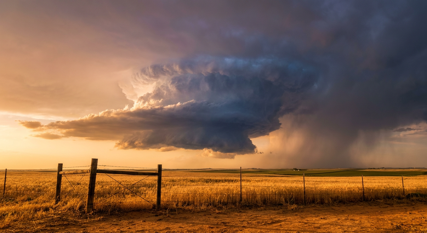
Let's start with the number that stops you cold. A Mesonet station northeast of Slaton, Texas, clocked a wind gust of 110 mph early in the day. That is not a tornado. That is a straight-line convective gust, and a reading like that is genuinely rare. Get this: that kind of wind will do damage on par with a strong tornado over a wider footprint. The data flags it as an extremely rare non-tornadic gust, and that's exactly the right way to think about it.
The Kansas flood emergency
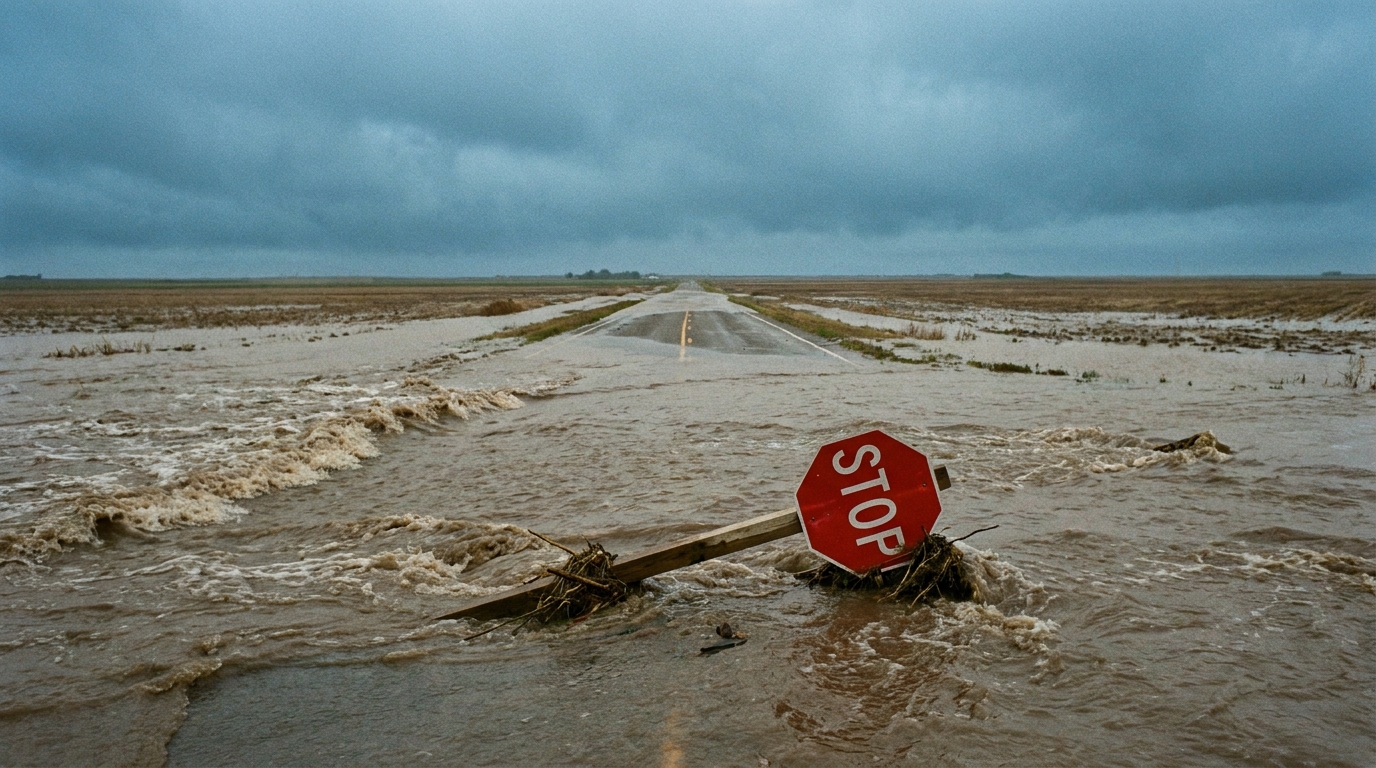
The most dangerous situation for people on the ground was water, not wind. A Particularly Dangerous Situation Flash Flood Emergency went up for Wichita, Andover, Haysville, Mulvane, and Derby, Kansas. That language is reserved for the worst of the worst. The result was catastrophic urban flooding that forced multiple boat and high-water rescues.
Missouri got hit too. In Cape Girardeau, flash flooding put up to four feet of water across roadways, trapped motorists, and pushed into the University School building. When water gets into a building like that, it tells you the rainfall rates were extreme and the drainage just couldn't keep up.
The wind story in Oklahoma
Northern Oklahoma got the wind. An Extremely Dangerous Situation Severe Thunderstorm Warning went out for Garfield and Noble counties. Inside that warning, a measured 96 mph gust near Breckenridge overturned a semi-truck on Highway 412. An EDS Severe Thunderstorm Warning is uncommon. The Weather Prediction Center reserves that wording for storms capable of widespread, life-threatening wind, and this one earned it.
The tornadoes
Now the tornadoes. The verified local storm reports confirm six tornado or waterspout touchdowns, and most were brief. Here's what the reports actually said:
- 7 S Aroya, Colorado (just west of Kit Carson): a brief cone tornado, on the ground roughly 20 seconds, reported by the public.
- 7 N Fort Lyon, Colorado (northeast of Las Animas): a brief tornado with clear ground circulation and debris in storm chaser video. A second spotter near Wiley saw funnels and brief ground circulations at the same time.
- 4 ENE Firstview, Colorado (near Cheyenne Wells): a trained spotter reported a feature repeatedly touching down and lifting with strong rotation.
- 4 NNE Wilson City, Missouri: a brief touchdown caught in chaser footage.
- 5 N Ava, Missouri: tree damage near Mt. Zion Church, with public video showing a funnel near the ground and radar suggesting lofted debris.
- 2 SW Bid-a-Wee, Florida: a waterspout off Panama City Beach that quickly fell apart as it came ashore.
Notice what I'm not doing here. I'm not slapping EF-ratings on any of these. NWS damage surveys take days, and as of this writing none of these reports carry a confirmed rating. When the surveys come in, we'll talk ratings. For now, these are reported and observed tornadoes, and that's the honest description.
What was forecast vs. what happened
The forecast going into and out of this event held up well. The previous blog called out the 110 mph Slaton gust specifically, and the verified data confirms it. It also flagged the broader wind streak across the southern Plains, and that's what we got: the 96 mph Breckenridge reading and the semi rollover fit right in.
The blog mentioned an 86 mph gust at the Stillwater airport that flipped a small plane and damaged others, plus curb-deep flooding through Payne County, Oklahoma. Those specifics aren't in the verified storm report set I'm working from, so I'm flagging them as claims from the forecast write-up rather than confirming them here. The big-picture call, though, severe wind and flooding focused on the southern and central Plains, was on the money.
The overall trend through the 24-hour window was listed as worsening, and the watch coverage backs that up. Tornado Watch 399 and Severe Thunderstorm Watches 397, 398, 400, and 401 covered large chunks of the central and eastern U.S. That's a busy map of watches for a single day.
What's coming next
The pattern is shifting, and the new headline is heat.
- The Storm Prediction Center has an Enhanced Risk today across eastern Montana into western North Dakota, with large hail and severe wind the main threats. There's a separate Slight Risk back east across North Carolina, around Charlotte and Raleigh.
- A broad Marginal Risk stretches across the mid-South and Ohio Valley, from Nashville and Louisville up toward Kansas City.
- The Weather Prediction Center has a Slight Risk for excessive rainfall today from the mid-Mississippi Valley into the southern Appalachians, plus a piece on the northern Plains. By Sunday and Monday that flood risk eases to Marginal and slides toward northwest Montana and the Great Lakes.
- Up around Glacier National Park, an upper low parks overhead this weekend with snow possible above roughly 6,500 feet. In late June, that's a fun one.
- The bigger story for next week is a significant, dangerous heat wave building across the central and eastern U.S. The Climate Prediction Center expects heat index values topping 100 to 105 degrees over many areas heading into the July 4 holiday, with warm nights cutting into overnight relief.
One more note for the night-sky crowd: NOAA's space weather forecast has active geomagnetic conditions possible on the 27th and 28th from a coronal-hole stream and a possible CME arrival. Nothing dramatic, but worth a glance if you're north and the skies clear.
Bottom Line
June 26 was a multi-hazard day, and the verified reports tell a consistent story: dangerous flooding in Kansas and Missouri, extreme straight-line winds in west Texas and northern Oklahoma, and a scattering of brief tornadoes across the High Plains and Missouri. The forecast nailed the wind threat, including that remarkable 110 mph gust near Slaton. Now the wind and water threat is moving north toward Montana and the Dakotas, and the real concern for the week ahead is heat, not storms. Drink water, check on the folks who don't have good air conditioning, and don't drive into floodwater. That last one was the difference between a close call and a rescue across Kansas and Missouri yesterday.