Blog Article
June 27, 2026 Severe Weather Recap: KY Flooding, Tornadoes
June 27, 2026 recap: deadly Kentucky flash flooding, an 86 mph wind gust in North Dakota, brief tornadoes, and a rare Oregon Tornado Warning. What happened and what's next.
June 27, 2026 Recap: Deadly Kentucky Flooding and Scattered Tornadoes Across the Plains
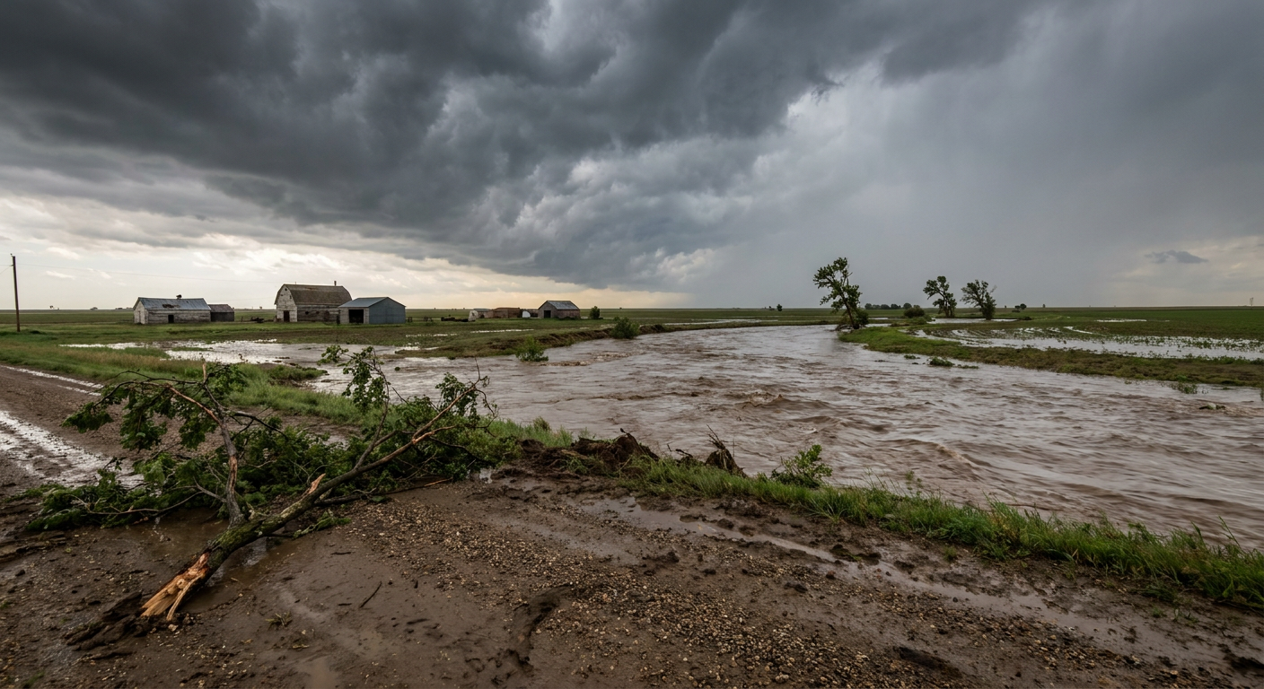
Y'all, the headline from June 27 wasn't the wind or the hail. It was the water. State officials confirmed at least four people lost their lives in regional flooding across Kentucky. That's the kind of number that stays with you, and it's where this recap has to start.
Flash Flood Emergencies went up in central Kentucky, in Madison and Jackson counties, and in southwestern Indiana, in Gibson and Pike counties. Rainfall totals reached up to 10 inches in spots. That's not a typo. Ten inches of rain in the wrong place over the wrong amount of time, and you get water moving through homes and over roads faster than anybody can react to it.
How the day unfolded
This was a multi-region day, and the threats stacked up across very different parts of the country.
The flooding was the worst of it. Emergency crews ran dozens of water rescues across Indiana, Kentucky, and Oklahoma. We're talking people pulled from flooded homes, off the roofs of vehicles, and out of submerged cars. Those are the moments that don't make the stat sheets but tell you exactly how serious the situation was on the ground.
Up north, the wind got going. Destructive straight-line convective winds hammered North Dakota and Montana. The standout measurement was an 86 mph gust near Trotters, North Dakota. That's a number that snaps trees and peels roofing.
Down in central Oklahoma, those same convective winds flipped multiple semi-trucks in Oklahoma County. Interstate 35 had to close near exit 119. If you've ever seen a loaded semi on its side from wind alone, you understand the kind of force we're describing.
The tornadoes
We had confirmed tornado reports come in from a few places, and I want to be careful here about what the data actually shows.
- 7 NNW Belfield, North Dakota (around 12:28 AM UTC June 28): A storm chaser relayed video of a brief tornado north of Belfield. It lifted quickly, and no damage was reported. Location based on radar. (LSR ID: iem_lsr:202606280048-KBIS)
- Stoy, Illinois (delayed report, around 7:00 PM UTC): Broadcast media shared video of a likely tornado partly obscured by a tree line, along with photos showing mostly small and a few medium limbs down near the intersection of IL 33 and North 600th Street. A separate report noted tree damage by two homes in Stoy and a funnel cloud video. (LSR ID: iem_lsr:202606280317-KILX)
The history summary also noted brief tornadoes reported in Montana and Kentucky and a rare Tornado Warning issued for Clackamas County in northwestern Oregon. That Oregon warning is genuinely unusual. That corner of the country seldom sees tornadic activity, and it's the kind of thing meteorologists make a mental note of.
I'll be straight with you: these were brief, low-end tornado events based on what came in. No EF-ratings have been assigned yet. NWS damage surveys take days to complete, and I'm not going to put a rating on these until the survey teams do their work.
What we forecast vs what happened
Yesterday morning's blog led with the Kentucky and Indiana flooding and the High Plains wind threat, and that held up. We flagged the catastrophic flash flooding, the rainfall totals up to 10 inches, and the four lives lost. The data confirms all of that.
We also called the North Dakota wind threat. The forecast mentioned a 70 mph gust at the Williston airport Saturday night and a brief tornado north of Belfield. That Belfield tornado shows up clean in the verified storm reports, and the broader North Dakota wind story played out with that 86 mph gust near Trotters.
Where I'll add honesty: the forecast was framed around the Dakotas and northern Iowa as the day's main severe setup, with the flooding presented as already-completed Friday events. The verified reports show the severe weather footprint was wider than that headline suggested, with confirmed wind damage reaching into North Carolina near Claremont, Missouri at Cape Girardeau, and Kentucky near Glen Dean. The overall signal was right. The geographic spread ran a little broader than the lead-in implied.
What's coming next
The pattern stays active up north for a couple more days, then heat takes over the conversation.
- Today and Monday: SPC has a Slight Risk (Level 2 of 5) across the Dakotas, northwest Minnesota, and northern Iowa. Large hail and severe wind are the main concerns, with a small hatched area where stones could reach 2 inches, hen-egg size. Monday keeps a Slight Risk going from the central and northern Plains into the Upper Midwest, with a low-end tornado mention.
- Flooding watch: WPC has Marginal to Slight excessive rainfall risks lingering across Montana, the northern Plains, and parts of the Tennessee Valley and eastern North Carolina. Already-saturated ground doesn't need much more.
- The big story by midweek: WPC is calling for a significant, dangerous, and potentially record-breaking heat wave to build across the central and eastern U.S. into the July 4th weekend. CPC's week-2 hazards outlook points to heat index values topping 100 to 105 degrees over many areas, with warm nights limiting overnight relief.
No tropical concerns to speak of. There's one low-end disturbance offshore of the Southeast with just a 20 percent chance of development over seven days.
Bottom Line
June 27 was a hard day. Four lives lost to flooding is the number that matters most, and it's a reminder that water, not wind, is the deadliest part of most severe weather setups. The wind and the brief tornadoes added to a busy, multi-region day, and the verified reports show the threat stretched from the northern Plains all the way to the Carolinas.
The forecast caught the big themes. The flooding and the High Plains wind were on the board ahead of time. Looking forward, keep your eyes north for a couple more rounds of storms, and start preparing now for serious heat building across the central and eastern states into the holiday weekend.