Blog Article
July 03, 2026 Severe Weather Recap: Wind and Floods
July 03, 2026 recap: a Great Lakes wind complex cut power to 170,000+ in Michigan while central Iowa saw over a foot of rain and boat rescues.

July 03, 2026 Severe Weather Recap: A Great Lakes Wind Machine and Historic Iowa Rainfall
Alright folks, if you were anywhere from central Iowa to southern Michigan yesterday, you know it was a long day. The headline number is a rough one: 173,093 customers without power in Wayne County, Michigan at the peak, and 166,249 of those outages were explicitly tied to wind damage. That's the kind of number that tells you a serious line of storms came through and meant business.
But before we get to the wind, let me tell you about the water.
The Iowa flood came first
Get this. Near Elkhart, Iowa, a rain gauge tallied a 24-hour rainfall total of 12.6 inches. Just up the road near Alleman, another observation came in at 12.57 inches. For central Iowa, that is an extreme hydrological event, plain and simple. Water rose fast enough that crews had to run boat-assisted evacuations to get folks out of buildings.
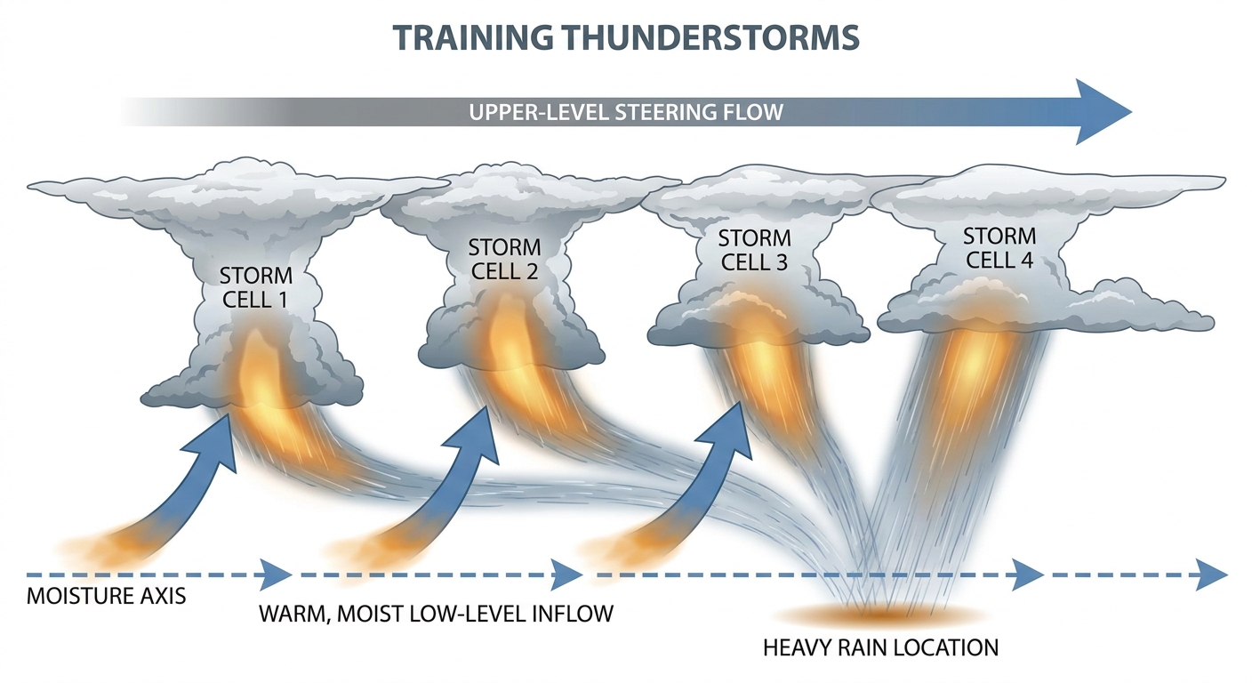
That kind of rainfall does not happen from a single passing thunderstorm. It happens when storms train, meaning they line up and pass over the same ground one after another, like railcars over a crossing. Each cell wrings out its moisture on the same neighborhoods, and the totals stack up in a hurry.
Then the wind took over
As the afternoon wore on, the storms organized into a bowing complex, an MCS, that raked the Great Lakes. Here is what the verified storm reports actually showed:
- Burlington, WI (1:36 PM local): Trees and power lines down, reported through the 911 call center.
- Tinley Park, IL (2:38 PM): A tree roughly 12 inches in diameter came down on a car, per the fire department.
- Bath, MI: Large tree limbs and a downed power line reported by the public.
- 1 W Edgewood, IN: Multiple power lines downed by thunderstorm wind between Lapel and Anderson, per the emergency manager.
The major-events log also notes a 79 mph wind gust measured at Kalamazoo Airport, Michigan, during the MCS transit, plus a major water rescue response at Lake Geneva, Wisconsin, following severe convective winds.
Out on the Plains, a tornado was reported 3 miles northwest of Hubbell, Nebraska, at 00:02Z (just after 7 PM Central), spotted by a storm chaser. That is the one confirmed tornado report in the data, and I want to be careful here: it was a report, not yet a rated survey. NWS damage surveys take days, so we don't have a rating, path, or duration to share. When those details come out, they come out honest.
Heat played its part too
It wasn't all storms. Down in Anne Arundel County, Maryland, Interstate 97 buckled under heat indices running between 100 and 115 degrees. Pavement expands when it bakes, and when there's nowhere for it to go, it heaves. That's a real hazard drivers don't always think about on a holiday-weekend road trip.
How it stacked up against the forecast
Here's the thing about yesterday's outlook. The blog we ran leaned hard into the Mid-Atlantic, with the Enhanced Risk sitting on Washington and Baltimore and that hatched 75 mph wind zone. The wind threat verified in the sense that damaging gusts did materialize across the region, with trees down 2 NNE of Newark, NY and an estimated 60 mph gust snapping a 15-to-17-inch tree near Ashley, Pennsylvania.
But the biggest, most disruptive impacts of the day landed farther west than the Mid-Atlantic headline suggested. The Great Lakes wind machine and that historic Iowa rainfall were the real story. The forecast caught the wind threat correctly, and it correctly flagged the Plains storms for wind and hail. Where it fell a little short was emphasis. The rainfall side of the ledger in Iowa deserved more billing than it got, and that is a fair thing to own.
What's coming next
The pattern is not done. For today, July 04, SPC has an Enhanced Risk over parts of the Mid-Atlantic, including Washington, Baltimore, and much of Delaware, with a Level 4 (45%) widespread damaging wind threat and a hatched zone where gusts could top 75 mph. The Central and Southern Plains sit under a Slight Risk for wind and hail.
WPC keeps a Slight Risk of excessive rainfall going over eastern Kansas and Oklahoma today, then shifts it into the Mid-Atlantic on Sunday and Monday. And looking further out, the extended discussion points to a major heatwave building over the South and Southeast next week, with the Climate Prediction Center flagging extreme heat risk across much of the western, central, and southeastern U.S. for the second week of July.
Bottom Line
July 03, 2026 was a two-front day. Central Iowa took on more than a foot of rain and needed boats to get people to safety, while a bowing storm complex knocked out power for over 170,000 customers in one Michigan county alone. The forecast nailed the wind threat but underplayed the flooding. Today the focus swings back to the Mid-Atlantic for damaging wind, and by next week the story turns to dangerous heat. If you're in the Plains or the Mid-Atlantic today, keep a way to get warnings, and if you're on the road in the Southeast next week, respect that heat.